
The IJssel is a Dutch distributary of the river Rhine that flows northward and ultimately discharges into the IJsselmeer, a North Sea natural harbour. It more immediately flows into the east-south channel around the Flevopolder, Flevoland which is kept at 3 metres below sea level. This body of water is then pumped up into the IJsselmeer.

Angerlo is a village in the municipality of Zevenaar, in the eastern Netherlands. It is located about 2 km south of Doesburg.

Lingewaard is a municipality in the eastern Netherlands. It is located in the province of Gelderland, in the most eastern part of the Betuwe. The municipality is situated in the lowlands between the major cities of Arnhem and Nijmegen, where most inhabitants work. Lingewaard was part of the Arnhem–Nijmegen metropolitan area until 2015.

Heerde is a municipality and a town in the eastern Netherlands. Compared to the rest of the Netherlands, Heerde is fairly religious, as are many of the towns and cities in the Veluwe region.

Purmerend is a city and municipality in the west of the Netherlands, in the province of North Holland and in the region of West Friesland. The city is surrounded by polders, such as the Purmer, Beemster and the Wormer. The city became the trade center of the region but the population grew relatively slowly. Only after 1960 did the population start to grow from around 10,000 to around 80,000 by the 2010s. From the 1960s onwards, Purmerend has seen major expansion and continues to do so. This expansion has turned Purmerend into a commuter town; many inhabitants of Purmerend work, go to school or spend their leisure time in Amsterdam. Purmerend is part of the Randstad, one of the largest conurbations in Europe.

Bad Nieuweschans is a village in the north-eastern Netherlands on the border with Germany. It forms part of the municipality of Oldambt. Nieuweschans means "new fortification (sconce)". In 2009, the word Bad ("spa") was prefixed to the name of the village to promote it as a tourist destination.
Daarlerveen is a village in the Dutch province of Overijssel. It is located in the municipality of Hellendoorn, about 2 km south of the town of Vroomshoop.
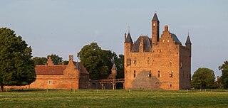
Doornenburg is a village to the south east of Angeren in the municipality of Lingewaard, Gelderland, the Netherlands. Doornenburg Castle is located near the village.

Pannerden is a village in the Dutch province of Gelderland. It is located in the municipality of Zevenaar.

Sauwerd is a village in the municipality of Het Hogeland, Groningen, Netherlands. Until the local government reorganization of 1990 the village was the head of the former municipality of Adorp.
Valburg is a village in the Dutch province of Gelderland. It is located in the municipality of Overbetuwe, about 10 km northwest of Nijmegen.
Ulrum is a village in the Dutch province of Groningen. It is located in the municipality of Het Hogeland.

Eexterveen is a village in the Dutch province of Drenthe. It is a part of the municipality of Aa en Hunze, and lies about 17 km east of Assen.

Eexterveenschekanaal is a village in the Dutch province of Drenthe. It is a part of the municipality of Aa en Hunze, and lies about 19 km east of Assen.

Erichem is a village in the Dutch province of Gelderland. It is a part of the municipality of Buren, and lies about 5 km west of Tiel.

Wanneperveen is a village in the Dutch province of Overijssel. It is located in the municipality of Steenwijkerland, about 4 km west of Meppel.

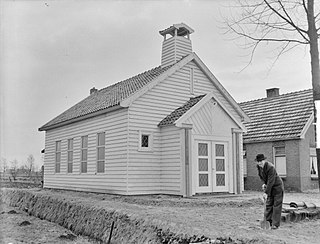
Firdgum is a small village in Waadhoeke in the province of Friesland, the Netherlands. It had a population of around 60 in January 2014.

Lytsewierrum is a small village in Súdwest-Fryslân municipality in the province of Friesland, the Netherlands. It had a population of around 68 in January 2017.

Hidaard is a small village in Súdwest-Fryslân municipality in the province of Friesland, the Netherlands. It had a population of around 130 in January 2017.

Greonterp is a small village in Súdwest-Fryslân municipality in the province of Friesland, the Netherlands. It had a population of around 85 in January 2017.


