
Lingewaard is a municipality in the eastern Netherlands. It is located in the province of Gelderland, in the most eastern part of the Betuwe. The municipality is situated in the lowlands between the major cities of Arnhem and Nijmegen, where many inhabitants work. Since 2021 it has been part of the Arnhem-Nijmegen Green Metropolitan Region, which aids planning and development in the region's eighteen municipalities.

Lobith is a village in the Dutch province of Gelderland. It is located in the municipality of Zevenaar. Traditionally, it is said that the Rhine enters the Netherlands at Lobith, although in reality, this happens about 4 km further upstream, near Spijk.
Broekhuizen is a village in the Dutch province of Limburg. It is a part of the municipality of Horst aan de Maas, and lies about 14 km north of Venlo.

Loenen aan de Vecht is a village in the Dutch province of Utrecht. It was the main village in the former municipality of Loenen. Since 2011 it has become part of the newly formed municipality of Stichtse Vecht. It lies about 10 km west of Hilversum.
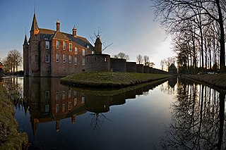
Oud-Zuilen is a village in the Dutch province of Utrecht. It is a part of the municipality of Stichtse Vecht, and lies about 4 km northwest of Utrecht. It is in an area called the "Vechtstreek". Zuylen Castle is located in the village.
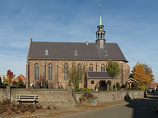
Kapel is a hamlet in the Dutch province of Gelderland. It is located in the municipality of Lingewaard, about 1 km north of the town of Gendt.
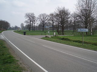
Padhuis is a hamlet in the Netherlands and is part of the Coevorden municipality in Drenthe.
Langerak is a hamlet in the Netherlands and is part of the Coevorden municipality in Drenthe.

Een-West is a hamlet in the Netherlands. It is part of the Noordenveld municipality in Drenthe.
Matsloot is a hamlet in the Netherlands, and is divided over the municipalities Groningen in province Groningen, and Noordenveld in Drenthe.

Peizerwold is a hamlet in the Netherlands and it part of the Noordenveld municipality in Drenthe.

Grubbenvorst is a village in the Dutch province of Limburg. It is located in the municipality of Horst aan de Maas, about 6 km northwest of Venlo.

Anreep is a hamlet in the Netherlands and is part of the Assen municipality in Drenthe.

Maasdam is a village in the Dutch province of South Holland. It is located about 14 km south of the city of Rotterdam, in the municipality of Hoeksche Waard, on the rural Hoeksche Waard island. From the 14th Century until around 1800, Maasdam was also the name of the local administrative area, the fief and later the "ambacht".

Nederland is a hamlet in the municipality Steenwijkerland in the province Overijssel, Netherlands. It has a population of about 15. 'Nederland' is the Dutch name for the Netherlands. Because of the comical value of the toponym, roadsigns with the name 'Nederland' are stolen frequently.

Baal is a hamlet in the Dutch province of Gelderland. It is located in the municipality of Lingewaard, about 1 km northeast of Bemmel, and located 1 kilometer north of Haalderen and is therefore part of Haalderen.

Bern is a hamlet in the Dutch province of Gelderland. It is located in the municipality of Zaltbommel, about 10 kilometres south of the town Zaltbommel.

Klein-Ulsda is a hamlet near Oudeschans in the municipality of Westerwolde in the Netherlands.

Doornik is a hamlet in the municipality of Lingewaard, between Lent and Bemmel, in the province of Gelderland, the Netherlands. Most of Doornik was destroyed at a Dyke breach in 1799, the village never recovered. Doornik had its own castle which burned down in 1823.

Zanddijk is a neighbourhood of Veere and former village in the municipality of Veere, Zeeland, Netherlands.


