Nijmegen is the largest city in the Dutch province of Gelderland and the tenth largest of the Netherlands as a whole. Located on the Waal River close to the German border, Nijmegen is one of the oldest cities in the Netherlands and the first to be recognized as such in Roman times. In 2005, it celebrated 2,000 years of existence.

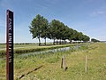
Betuwe, also known in English as Batavia, is a historical and geographical region in the Netherlands, forming large fertile islands in the river delta formed by the waters of the Rhine and Meuse rivers. During the Roman Empire, it was an important frontier region and source of imperial soldiers. Its name is possibly pre-Roman.

Arnhem is a city and municipality situated in the eastern part of the Netherlands, near the German border. It is the capital of the province of Gelderland, located on both banks of the rivers Nederrijn and Sint-Jansbeek, which was the source of the city's development.

Gelderland, also known as Guelders in English, is a province of the Netherlands, located in the centre-east of the country. With a total area of 5,136 km2 (1,983 sq mi) of which 176 km2 (68 sq mi) is water, it is the largest province of the Netherlands by land area, and second by total area. Gelderland shares borders with six other provinces and the German state of North Rhine-Westphalia.

Wageningen is a municipality and a historic city in the central Netherlands, in the province of Gelderland. It is famous for Wageningen University, which specialises in life sciences. The municipality had a population of 39,635 in 2021, of which many thousands are students from over 150 countries.

Lingewaard is a municipality in the eastern Netherlands. It is located in the province of Gelderland, in the most eastern part of the Betuwe. The municipality is situated in the lowlands between the major cities of Arnhem and Nijmegen, where many inhabitants work. Since 2021 it has been part of the Arnhem-Nijmegen Green Metropolitan Region, which aids planning and development in the region's eighteen municipalities.

Doesburg is a municipality and a city in the eastern Netherlands in the province of Gelderland. Doesburg received city rights in 1237 and had a population of 11,064 in 2021. The city is situated on the right bank of the River IJssel at its confluence with the River Oude IJssel. It is part of the Arnhem-Nijmegen Green Metropolitan Region, which aids planning and development in the region's eighteen municipalities.

Overbetuwe is a municipality in the province of Gelderland in the Netherlands. It was formed on 1 January 2001 as a merger of three former municipalities: Elst, Heteren and Valburg. Overbetuwe is bordered in the north by the river Rhine and in the south by the river Waal. The town hall is located in Elst, the largest town in the municipality. Since 2021 it has been part of the Arnhem-Nijmegen Green Metropolitan Region (Dutch: Groene Metropoolregio Arnhem-Nijmegen, which aids planning and development in the region's eighteen municipalities.

The Linge is a river in the Betuwe that is 99.8 km long, which makes it one of the longest rivers that flow entirely within the Netherlands.

Huissen is a city with city rights in the Netherlands, in the province of Gelderland. The town is located in the Betuwe region and belongs to the municipality of Lingewaard, in the area between the major cities of Arnhem and Nijmegen. Huissen is situated along the rivers Nederrijn and Linge. The city has a population of 19,414.

Molenhoek is a village located in south-eastern Netherlands partially in the municipality of Mook en Middelaar in the province of Limburg and partially in the municipality of Heumen in the province of Gelderland. It is also the northernmost town of Limburg and thus its nickname is "De Poort van Limburg".

Gendt is a small city with city rights in the Netherlands, in the province of Gelderland. The town is located in the Betuwe region, and is part of the municipality of Lingewaard. Gendt is situated along the rivers Waal and Linge. It has a population of 7,230.

Angeren is a village in the municipality of Lingewaard, Gelderland province, Netherlands. It has a population of 2,851, and is located in the very eastern tip of the Betuwe, 2 km to the south of Huissen, between the cities of Arnhem and Nijmegen.

Elst is a town in the municipality of Overbetuwe in the Dutch province of Gelderland. It is situated in the Betuwe, between the cities of Arnhem and Nijmegen. In January 2022 the town had 22,509 inhabitants.

Haalderen is a village in the Netherlands, in the province of Gelderland. The village is located in the Betuwe region, and belongs to the municipality of Lingewaard. Haalderen is situated along the rivers Waal and Linge. It has a population of 2,061.

Baal is a hamlet in the Dutch province of Gelderland. It is located in the municipality of Lingewaard, about 1 km northeast of Bemmel, and located 1 kilometer north of Haalderen and is therefore part of Haalderen.

Doornik is a hamlet in the municipality of Lingewaard, between Lent and Bemmel, in the province of Gelderland, the Netherlands. Most of Doornik was destroyed at a Dyke breach in 1799, the village never recovered. Doornik had its own castle which burned down in 1823.

The Battle of Nijmegen, also known as the Liberation of Nijmegen, occurred from 17 to 20 September 1944, as part of Operation Market Garden during World War II.
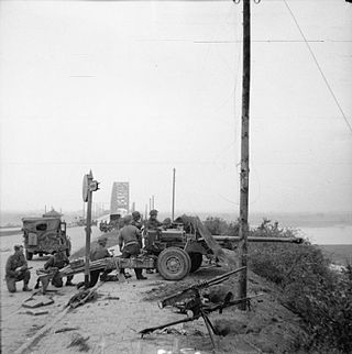
The Battle of the Nijmegen salient or the Defence of the Nijmegen bridgehead was a series of engagements that took place in the Netherlands during World War II between 30 September and 8 October 1944. The battle occurred in the aftermath of Operation Market Garden, a failed attempt by the Allies to cut off German forces in the Netherlands and end the war quickly.