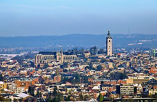
Mons is a city and municipality of Wallonia, and the capital of the province of Hainaut, Belgium.

Lingewaard is a municipality in the eastern Netherlands. It is located in the province of Gelderland, in the most eastern part of the Betuwe. The municipality is situated in the lowlands between the major cities of Arnhem and Nijmegen, where most inhabitants work. Lingewaard was part of the Arnhem–Nijmegen metropolitan area until 2015.

Angeren is a village in the municipality of Lingewaard, Gelderland province, Netherlands. It has a population of 2,851, and is located in the very eastern tip of the Betuwe, 2 km to the south of Huissen, between the cities of Arnhem and Nijmegen.

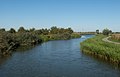
Pannerden is a village in the Dutch province of Gelderland. It is located in the municipality of Zevenaar.

Pápa[ˈpaːpɒ] is a historical town in Veszprém county, Hungary, located close to the northern edge of the Bakony Hills, and noted for its baroque architecture. With its 32,473 inhabitants (2011), it is the cultural, economic and tourism centre of the region.

Westerbork is a village in the municipality of Midden-Drenthe in the Netherlands. It is located in the middle of the eastern province of Drenthe. During World War II, the Westerbork transit camp was located near the village. The Westerbork Synthesis Radio Telescope and the Camp Westerbork Museum are now situated at the site.

Kralendijk is the capital city and main port of the island of Bonaire in the Caribbean Netherlands. The language spoken in the town is Papiamentu, but Dutch and English are widely used. As of 2017, the town had a population of 10,620. In Papiamentu, the town is often called Playa or "beach".

Bennekom is a village and parish in the Netherlands, which is part of the Municipality of Ede in the south-west of the Veluwe district of the Province of Gelderland. It adjoins the town of Wageningen on the Lower-Rhine to the south, and Ede to the north, Veenendaal to the west and Renkum to the east. The western boundary of the parish follows the canalized River Grift and is also the boundary with the Province of Utrecht.

Numansdorp is a village and former municipality in the province South Holland in the Netherlands and is located on the island Hoeksche Waard near the Hollands Diep. On 1 January 1984, the municipalities Numansdorp and Klaaswaal were merged into one municipality called Cromstrijen. Cromstrijen was merged into the new municipality Hoeksche Waard in January 2019.
Noordlaren is a village in the municipality of Groningen in the Dutch province of Groningen. It had a population of around 545 in 2021.

Langbroek is a village in the Dutch province of Utrecht. It is a part of the municipality of Wijk bij Duurstede, and lies about 11 km southeast of Zeist. The village is the merger of Overlangbroek and Nederlangbroek

Loenen aan de Vecht is a village in the Dutch province of Utrecht. It was the main village in the former municipality of Loenen. Since 2011 it has become part of the newly formed municipality of Stichtse Vecht. It lies about 10 km west of Hilversum.

Havelte is a village in the Northeastern Netherlands. It is located in the municipality of Westerveld, Drenthe, about 60 km south-southwest of Groningen and 120 km northeast of Amsterdam. As of 1 January 2021, it had a population of 3,825.

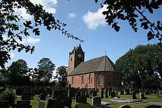
Termunten is a village in the Dutch province of Groningen. It is a part of the municipality of Eemsdelta, and lies about 33 km east of Groningen.

Ingen is a village in the Dutch province of Gelderland. It is a part of the municipality of Buren, and lies about 9 km south-west of Veenendaal. Before 1999 the town was part of the municipality of Lienden from 1818 till 1999. The houses are widely spread into a bowl form. The houses link to the townships De Ganzert and Eck en Wiel in the West.

Fort Pannerden is a disused military fort situated near the village of Pannerden in the southeast of the Netherlands. In November 2006, it became the focus of national news stories because a group of squatters were evicted in a large-scale operation by police, helped by the army. Later on in the same month, it was resquatted.

Stedum is a village in the Dutch province of Groningen. It is located in the municipality of Eemsdelta, about 15 km northeast of the city of Groningen.
Oentsjerk is a village in Tytsjerksteradiel in the province of Friesland, the Netherlands. It had a population of around 1,784 in January 2017. Oentsjerk is known for its agricultural practical training centre and large elderly care facility, the two largest employers of the town.

Marsum or Marssum is a village in Waadhoeke in the province of Friesland, the Netherlands. It had a population of around 1,052 in January 2017. Before 2018, the village was part of the Menameradiel municipality.

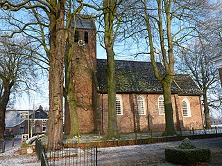
Castle Doornenburg is a Dutch castle from the 13th century.