A valley is an elongated low area often running between hills or mountains and typically containing a river or stream running from one end to the other. Most valleys are formed by erosion of the land surface by rivers or streams over a very long period. Some valleys are formed through erosion by glacial ice. These glaciers may remain present in valleys in high mountains or polar areas.

An entrenched river, or entrenched stream is a river or stream that flows in a narrow trench or valley cut into a plain or relatively level upland. Because of lateral erosion streams flowing over gentle slopes over a time develops meandering course. Meanders form where gradient is very gentle, for example in floodplain and delta. Meandering is the feature of the middle and final course of the river. But very deep and wide meanders can also be found cutting hard rocks. Such meanders are called incised or entrenched meanders. The exception is that entrenched meanders are formed during the upliftment of land where river is young. They widen and deepen over time and can be found as deep gorges or canyons in hard rock. In the case of an entrenched stream or river, it is often presumed that the watercourse has inherited its course by cutting down into bedrock from a pre-existing plain with little modification of the original course. The down-cutting of the river system could be the result not only of tectonic uplift but also of other factors such as river piracy, decrease of load, increase of runoff, extension of the drainage basin, or change in base level such as a fall in sea level. General, nongeneric terminology for either a river or stream that flows in a narrow trench or valley, for which evidence of a preexisting plain or relatively level upland can be either absent or present is either valley meander or meander valley with the latter term being preferred in literature.

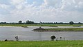
Bemmel is a town in the eastern Netherlands, in the province of Gelderland. It is located in the Betuwe region, and falls under the municipality of Lingewaard. The town is situated between the major cities of Arnhem and Nijmegen, and is bordered by the Waal river in the south. Bemmel has a population of 12,161.

A groyne is a rigid hydraulic structure built perpendicularly from an ocean shore or a river bank, interrupting water flow and limiting the movement of sediment. It is usually made out of wood, concrete, or stone. In the ocean, groynes create beaches, prevent beach erosion caused by longshore drift where this is the dominant process and facilitate beach nourishment. There is also often cross-shore movement which if longer than the groyne will limit its effectiveness. In a river, groynes slow down the process of erosion and prevent ice-jamming, which in turn aids navigation.
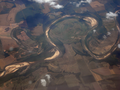
An oxbow lake is a U-shaped lake or pool that forms when a wide meander of a river is cut off, creating a free-standing body of water. The word "oxbow" can also refer to a U-shaped bend in a river or stream, whether or not it is cut off from the main stream. It takes its name from an oxbow which is part of a harness for oxen to pull a plough or cart.

The Kobuk River, also known by the names Kooak, Kowak, Kubuk, Kuvuk, and Putnam, is a river located in the Arctic region of northwestern Alaska in the United States. It is approximately 280 miles (451 km) long. Draining a basin with an area of 12,300 square miles (32,000 km2), the Kobuk River is among the largest rivers in northwest Alaska, with widths of up to 1,500 feet and flows reaching speeds of 3–5 miles per hour in its lower and middle reaches. The average elevation for the Kobuk River Basin is 1,300 feet (400 m) above sea level, ranging from sea level at its mouth on the Bering Sea to 11,400 feet near its headwaters in the Brooks Range.
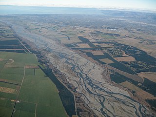
An alluvial plain is a plain created by the deposition of sediment over a long period by one or more rivers coming from highland regions, from which alluvial soil forms. A floodplain is part of the process, being the smaller area over which the rivers flood at a particular time. In contrast, the alluvial plain is the larger area representing the region over which the floodplains have shifted over geological time.

Coulee, or coulée, is any of various different landforms, all of which are kinds of valleys or drainage zones. The word coulee comes from the Canadian French coulée, from French couler 'to flow'.

The Luangwa River is one of the major tributaries of the Zambezi River, and one of the four biggest rivers of Zambia. The river generally floods in the rainy season and then falls considerably in the dry season. It is one of the biggest unaltered rivers in Southern Africa and the 52,000 square kilometres (20,000 sq mi) that make up the surrounding valley are home to abundant wildlife.

In geomorphology a river is said to be rejuvenated when it is eroding the landscape in response to a lowering of its base level. The process is often a result of a sudden fall in sea level or the rise of land. The disturbance enables a rise in the river's gravitational potential energy change per unit distance, increasing its riverbed erosion rate. The erosion occurs as a result of the river adjusting to its new base level.

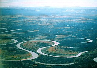
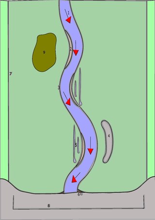
A meander is one of a series of regular sinuous curves in the channel of a river or other watercourse. It is produced as a watercourse erodes the sediments of an outer, concave bank and deposits sediments on an inner, convex bank which is typically a point bar. The result of this coupled erosion and sedimentation is the formation of a sinuous course as the channel migrates back and forth across the axis of a floodplain.

The Willamette Valley ecoregion is a Level III ecoregion designated by the United States Environmental Protection Agency in the U.S. states of Oregon and Washington. Slightly larger than the Willamette Valley for which it is named, the ecoregion contains fluvial terraces and floodplains of the Willamette River system, scattered hills, buttes, and adjacent foothills. It is distinguished from the neighboring Coast Range, Cascades, and Klamath Mountains ecoregions by lower precipitation, lower elevation, less relief, and a different mosaic of vegetation. Mean annual rainfall is 37 to 60 inches, and summers are generally dry. Historically, the region was covered by rolling prairies, oak savanna, coniferous forests, extensive wetlands, and deciduous riparian forests. Today, it contains the bulk of Oregon's population, industry, commerce, and agriculture. Productive soils and a temperate climate make it one of the most important agricultural areas in Oregon.

A stream is a continuous body of surface water flowing within the bed and banks of a channel. Depending on its location or certain characteristics, a stream may be referred to by a variety of local or regional names. Long, large streams are usually called rivers, while smaller, less voluminous and more intermittent streams are known as streamlets, brooks or creeks.
In geology, a backswamp is a type of depositional environment commonly found in a floodplain. It is where deposits of fine silts and clays settle after a flood. These deposits create a marsh-like landscape that is often poorly drained and usually lower than the rest of the floodplain.

In sedimentary geology and fluvial geomorphology, avulsion is the rapid abandonment of a river channel and the formation of a new river channel. Avulsions occur as a result of channel slopes that are much less steep than the slope that the river could travel if it took a new course.

An alluvial river is one in which the bed and banks are made up of mobile sediment and/or soil. Alluvial rivers are self-formed, meaning that their channels are shaped by the magnitude and frequency of the floods that they experience, and the ability of these floods to erode, deposit, and transport sediment. For this reason, alluvial rivers can assume a number of forms based on the properties of their banks; the flows they experience; the local riparian ecology; and the amount, size, and type of sediment that they carry.

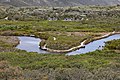
Riparian-zone restoration is the ecological restoration of riparian-zonehabitats of streams, rivers, springs, lakes, floodplains, and other hydrologic ecologies. A riparian zone or riparian area is the interface between land and a river or stream. Riparian is also the proper nomenclature for one of the fifteen terrestrial biomes of the earth; the habitats of plant and animal communities along the margins and river banks are called riparian vegetation, characterized by aquatic plants and animals that favor them. Riparian zones are significant in ecology, environmental management, and civil engineering because of their role in soil conservation, their habitat biodiversity, and the influence they have on fauna and aquatic ecosystems, including grassland, woodland, wetland or sub-surface features such as water tables. In some regions the terms riparian woodland, riparian forest, riparian buffer zone, or riparian strip are used to characterize a riparian zone.
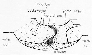
A Yazoo stream is a geologic and hydrologic term for any tributary stream that runs parallel to, and within the floodplain of a larger river for considerable distance, before eventually joining it. This is especially the characteristic when such a stream is forced to flow along the base of the main river's natural levee. Where the two meet is known as a "belated confluence" or a "deferred junction". The name is derived from an exterminated Native American tribe, the Yazoo Indians. The Choctaw word is translated to "River of Death" because of the strong flows under its bank full stage.

A slip-off slope is a depositional landform that occurs on the inside convex bank of a meandering river. The term can refer to two different features: one in a freely meandering river with a floodplain and the other in an entrenched river.
The Mississippi Alluvial Plain is a Level III ecoregion designated by the Environmental Protection Agency (EPA) in seven U.S. states, though predominantly in Arkansas, Louisiana, and Mississippi. It parallels the Mississippi River from the Midwestern United States to the Gulf of Mexico.