Riparian buffer

Last updated
A riparian buffer of vegetation lining a farm creek in Story County, Iowa Riparian buffer on Bear Creek in Story County, Iowa.JPG
A riparian buffer of vegetation lining a farm creek in Story County, Iowa

A riparian buffer or stream buffer is a vegetated area (a "buffer strip") near a stream, usually forested, which helps shade and partially protect the stream from the impact of adjacent land uses. It plays a key role in increasing water quality in associated streams, rivers, and lakes, thus providing environmental benefits. With the decline of many aquatic ecosystems due to agriculture, riparian buffers have become a very common conservation practice aimed at increasing water quality and reducing pollution.

Contents

Benefits

Riparian buffers act to intercept sediment, nutrients, pesticides, and other materials in surface runoff and reduce nutrients and other pollutants in shallow subsurface water flow. [1] They also serve to provide habitat and wildlife corridors in primarily agricultural areas. They can also be key in reducing erosion by providing stream bank stabilization. Large scale results have demonstrated that the expansion of riparian buffers through the deployment of plantations systems can effectively reduce nitrogen emissions to water and soil loss by wind erosion, while simultaneously providing substantial environmental co-benefits, having limited negative effects on current agricultural production. [2]

Water quality benefits

Riparian buffers intercept sediment and nutrients. They counteract eutrophication in downstream lakes and ponds which can be detrimental to aquatic habitats because of large fish kills that occur upon large-scale eutrophication. Riparian buffers keep chemicals, like pesticides, that can be harmful to aquatic life out of the water. Some pesticides can be especially harmful if they bioaccumulate in the organism, with the chemicals reaching harmful levels once they are ready for human consumption. Riparian buffers also stabilise the bank surrounding the water body which is important since erosion can be a major problem in agricultural regions when cut (eroded) banks can take land out of production. Erosion can also lead to sedimentation and siltation of downstream lakes, ponds, and reservoirs. Siltation can greatly reduce the life span of reservoirs and the dams that create the reservoirs.

Habitat benefits

Riparian buffers can act as crucial habitat for a large number of species, especially those who have lost habitat due to agricultural land being put into production. The habitat provided by the buffers also double as corridors for species that have had their habitat fragmented by various land uses. By adding this vegetated area of land near a water source, it increases biodiversity by allowing species an area to re-establish after being displaced due to non-conservation land use. With this re-establishment, the number of native species and biodiversity in general can be increased. The large trees in the first zone of the riparian buffer provide shade and therefore cooling for the water, increasing productivity and increasing habitat quality for aquatic species. When branches and stumps (large woody debris) fall into the stream from the riparian zone, more stream habitat features are created. Carbon is added as an energy source for biota in the stream.

Economic benefits

Buffers increase land value and allow for the production of profitable alternative crops. Vegetation such as black walnut and hazelnut, which can be profitably harvested, can be incorporated into the riparian buffer. Lease fees for hunting can also be increased as the larger habitat means that the land will be more sought-after for hunting purposes. Designing buffer zones based on their hydrological function instead of a traditionally used fixed width method, can be economically beneficial in forestry practices. [3]

Design

Ground level view of riparian buffer between Munson Pond (off camera left) and an agricultural operation (off camera right), in Kelowna, British Columbia

A riparian buffer is usually split into three different zones, each having its own specific purpose for filtering runoff and interacting with the adjacent aquatic system. Buffer design is a key element in the effectiveness of the buffer. It is generally recommended that native species be chosen to plant in these three zones, with the general width of the buffer being 50 feet (15 m) on each side of the stream. [4]

Zone 1
This zone should function mainly to shade the water source and act as a bank stabilizer. The zone should include large native tree species that grow fast and can quickly act to perform these tasks. Although this is usually the smallest of the three zones and absorbs the fewest contaminants, most of the contaminants have been eliminated by Zone 2 and Zone 3. [5]
Zone 2
Usually made up of native shrubs, this zone provides a habitat for wildlife, including nesting areas for bird species. This zone also acts to slow and absorb contaminants that Zone 3 has missed. The zone is an important transition between grassland and forest. [5]
Zone 3
This zone is important as the first line of defense against contaminants. It consists mostly of native grasses and serves primarily to slow water runoff and begin to absorb contaminants before they reach the other zones. Although these grass strips should be one of the widest zones, they are also the easiest to install. [5]
Streambed Zone
The streambed zone of the riparian area is linked closely to Zone 1. Zone 1 provides fallen limbs, trees, and tree roots that in turn slow water flow, reducing erosional processes associated with increased water flow and flooding. This woody debris also increases habitat and cover for various aquatic species.

The US National Agroforestry Center has developed a filter strip design tool called AgBufferBuilder, which is a GIS-based computer program for designing vegetative filter strips around agricultural fields that utilizes terrain analysis to account for spatially non-uniform runoff.

Forest management

Logging is sometimes recommended as a management practice in riparian buffers, usually to provide economic incentive. However, some studies have shown that logging can harm wildlife populations, especially birds. A study by the University of Minnesota found that there was a correlation between the harvesting of timber in riparian buffers and a decline in bird populations. [6] Therefore, logging is generally discouraged as an environmental practice, and left to be done in designated logging areas.

Conservation incentives

The Conservation Reserve Program (CRP), a farming assistance program in the United States, provides many incentives to landowners to encourage them to install riparian buffers around water systems that have a high chance of non-point water pollution and are highly erodible. For example, the Nebraska system of Riparian Buffer Payments offers payments for the cost of setup, a sign up bonus, and annual rental payments.

These incentives are offered to agriculturists to compensate them for their economic loss of taking this land out of production. If the land is highly erodible and produces little economic gain, it can sometimes be more economic to take advantage of these CRP programs. [7]

Effectiveness

Riparian buffers have undergone much scrutiny about their effectiveness, resulting in thorough testing and monitoring. A study done by the University of Georgia, conducted over a nine-year period, monitored the amounts of fertilizers that reached the watershed from the source of the application. It found that these buffers removed at least 60% of the nitrogen in the runoff, and at least 65% of the phosphorus from the fertilizer application. The same study showed that the effectiveness of the Zone 3 was much greater than that of both Zone 1 and 2 at removing contaminants. [8] But another study in 2017 did not find efficiency (or a very limiting capacity) for reducing glyphosate and AMPA leaching to streams; spontaneous herbaceous vegetation RBS is as efficient as Salix plantations and measures of glyphosate in runoff after a year, suggest an unexpected persistence and even a capacity of RBS to potentially favor glyphosate infiltration up to 70 cm depth in the soil. [9] [ clarification needed ]

Long-term sustainability

After the initial installation of the riparian buffer, relatively little maintenance needs to be performed to keep the buffer in good condition. Once the trees and grasses reach maturity, they regenerate naturally and make a more effective buffer. The sustainability of the riparian buffer makes it extremely attractive to landowners, since they do relatively little work and still receive payments. Riparian buffers have the potential to be the most effective ways to protect aquatic biodiversity, water quality and manage water resources in developing countries that lack the funds to install water treatment and supply systems in midsize and small towns.

Species selection

Species selection based on an area in Nebraska, as an example:

In Zone 1
Cottonwood, Bur Oak, Hackberry, Swamp White Oak, Siberian Elm, Honeylocust, Silver Maple, Black Walnut, and Northern Red Oak. [10]
In Zone 2
Manchurian apricot, Silver Buffaloberry, Caragana, Black Cherry, Chokecherry, Sandcherry, Peking Cotoneaster, Midwest Crabapple, Golden Currant, Elderberry, Washington Hawthorn, American Hazel, Amur Honeysuckle, Common Lilac, Amur Maple, American Plum, and Skunkbush Sumac. [10]
In Zone 3
Western Wheatgrass, Big Bluestem, Sand Bluestem, Sideoats Grama, Blue Grama, Hairy Grama, Buffalo Grass, Sand Lovegrass, Switchgrass, Little Bluestem, Indiangrass, Prairie Cordgrass, Prairie Dropseed, Tall Dropseed, Needleandthread, Green Needlegrass.

See also

Related Research Articles

<span class="mw-page-title-main">Soil erosion</span> Displacement of soil by water, wind, and lifeforms

Soil erosion is the denudation or wearing away of the upper layer of soil. It is a form of soil degradation. This natural process is caused by the dynamic activity of erosive agents, that is, water, ice (glaciers), snow, air (wind), plants, and animals. In accordance with these agents, erosion is sometimes divided into water erosion, glacial erosion, snow erosion, wind (aeolean) erosion, zoogenic erosion and anthropogenic erosion such as tillage erosion. Soil erosion may be a slow process that continues relatively unnoticed, or it may occur at an alarming rate causing a serious loss of topsoil. The loss of soil from farmland may be reflected in reduced crop production potential, lower surface water quality and damaged drainage networks. Soil erosion could also cause sinkholes.

<span class="mw-page-title-main">Buffer zone</span> Intermediate region, typically between belligerent entities

A buffer zone is a neutral zonal area that lies between two or more bodies of land, usually pertaining to countries. Depending on the type of buffer zone, it may serve to separate regions or conjoin them. Common types of buffer zones are demilitarized zones, border zones and certain restrictive easement zones and green belts. Such zones may be comprised by a sovereign state, forming a buffer state.

<span class="mw-page-title-main">Windbreak</span> Rows of trees or shrubs planted to provide shelter from the wind

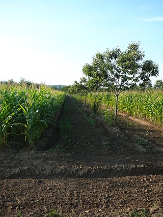
A windbreak (shelterbelt) is a planting usually made up of one or more rows of trees or shrubs planted in such a manner as to provide shelter from the wind and to protect soil from erosion. They are commonly planted in hedgerows around the edges of fields on farms. If designed properly, windbreaks around a home can reduce the cost of heating and cooling and save energy. Windbreaks are also planted to help keep snow from drifting onto roadways or yards. Farmers sometimes use windbreaks to keep snow drifts on farm land that will provide water when the snow melts in the spring. Other benefits include contributing to a microclimate around crops, providing habitat for wildlife, and, in some regions, providing wood if the trees are harvested.

<span class="mw-page-title-main">Grazing</span> Feeding livestock on forage

In agriculture, grazing is a method of animal husbandry whereby domestic livestock are allowed outdoors to roam around and consume wild vegetations in order to convert the otherwise indigestible cellulose within grass and other forages into meat, milk, wool and other animal products, often on land unsuitable for arable farming.

<span class="mw-page-title-main">Agroforestry</span> Land use management system

Agroforestry is a land use management system in which trees or shrubs are grown around or among crops or pastureland. Trees produce a wide range of useful and marketable products from fruits/nuts, medicines, wood products, etc. This intentional combination of agriculture and forestry has multiple benefits, such as greatly enhanced yields from staple food crops, enhanced farmer livelihoods from income generation, increased biodiversity, improved soil structure and health, reduced erosion, and carbon sequestration. Agroforestry practices are highly beneficial in the tropics, especially in subsistence smallholdings in sub-Saharan Africa and have been found to be beneficial in Europe and the United States.

<span class="mw-page-title-main">Agricultural wastewater treatment</span> Farm management for controlling pollution from confined animal operations and surface runoff

Agricultural wastewater treatment is a farm management agenda for controlling pollution from confined animal operations and from surface runoff that may be contaminated by chemicals in fertilizer, pesticides, animal slurry, crop residues or irrigation water. Agricultural wastewater treatment is required for continuous confined animal operations like milk and egg production. It may be performed in plants using mechanized treatment units similar to those used for industrial wastewater. Where land is available for ponds, settling basins and facultative lagoons may have lower operational costs for seasonal use conditions from breeding or harvest cycles. Animal slurries are usually treated by containment in anaerobic lagoons before disposal by spray or trickle application to grassland. Constructed wetlands are sometimes used to facilitate treatment of animal wastes.

<span class="mw-page-title-main">Riparian zone</span> Interface between land and a river or stream

A riparian zone or riparian area is the interface between land and a river or stream. Riparian is also the proper nomenclature for one of the terrestrial biomes of the Earth. Plant habitats and communities along the river margins and banks are called riparian vegetation, characterized by hydrophilic plants. Riparian zones are important in ecology, environmental resource management, and civil engineering because of their role in soil conservation, their habitat biodiversity, and the influence they have on fauna and aquatic ecosystems, including grasslands, woodlands, wetlands, or even non-vegetative areas. In some regions, the terms riparian woodland, riparian forest, riparian buffer zone,riparian corridor, and riparian strip are used to characterize a riparian zone. The word riparian is derived from Latin ripa, meaning "river bank".

<span class="mw-page-title-main">Erosion control</span> Practice of preventing soil erosion in agriculture and land development

Erosion control is the practice of preventing or controlling wind or water erosion in agriculture, land development, coastal areas, river banks and construction. Effective erosion controls handle surface runoff and are important techniques in preventing water pollution, soil loss, wildlife habitat loss and human property loss.

<span class="mw-page-title-main">Nonpoint source pollution</span> Pollution resulting from multiple sources

Nonpoint source (NPS) pollution refers to diffuse contamination of water or air that does not originate from a single discrete source. This type of pollution is often the cumulative effect of small amounts of contaminants gathered from a large area. It is in contrast to point source pollution which results from a single source. Nonpoint source pollution generally results from land runoff, precipitation, atmospheric deposition, drainage, seepage, or hydrological modification where tracing pollution back to a single source is difficult. Nonpoint source water pollution affects a water body from sources such as polluted runoff from agricultural areas draining into a river, or wind-borne debris blowing out to sea. Nonpoint source air pollution affects air quality, from sources such as smokestacks or car tailpipes. Although these pollutants have originated from a point source, the long-range transport ability and multiple sources of the pollutant make it a nonpoint source of pollution; if the discharges were to occur to a body of water or into the atmosphere at a single location, the pollution would be single-point.

<span class="mw-page-title-main">Surface runoff</span> Flow of excess rainwater not infiltrating in the ground over its surface

Surface runoff is the flow of water occurring on the ground surface when excess rainwater, stormwater, meltwater, or other sources, can no longer sufficiently rapidly infiltrate in the soil. This can occur when the soil is saturated by water to its full capacity, and the rain arrives more quickly than the soil can absorb it. Surface runoff often occurs because impervious areas do not allow water to soak into the ground. Furthermore, runoff can occur either through natural or man-made processes. Surface runoff is a major component of the water cycle. It is the primary agent of soil erosion by water. The land area producing runoff that drains to a common point is called a drainage basin.

<span class="mw-page-title-main">Conservation Reserve Program</span> U.S. federal aid program

The Conservation Reserve Program (CRP) is a cost-share and rental payment program of the United States Department of Agriculture (USDA). Under the program, the government pays farmers to take certain agriculturally used croplands out of production and convert them to vegetative cover, such as cultivated or native bunchgrasses and grasslands, wildlife and pollinators food and shelter plantings, windbreak and shade trees, filter and buffer strips, grassed waterways, and riparian buffers. The purpose of the program is to reduce land erosion, improve water quality and effect wildlife benefits.

<span class="mw-page-title-main">Buffer strip</span>

A buffer strip is an area of land maintained in permanent vegetation that helps to control air quality, soil quality, and water quality, along with other environmental problems, dealing primarily on land that is used in agriculture. Buffer strips trap sediment, and enhance filtration of nutrients and pesticides by slowing down surface runoff that could enter the local surface waters. The root systems of the planted vegetation in these buffers hold soil particles together which alleviate the soil of wind erosion and stabilize stream banks providing protection against substantial erosion and landslides. Farmers can also use buffer strips to square up existing crop fields to provide safety for equipment while also farming more efficiently.

<span class="mw-page-title-main">Freshwater biology</span> The scientific study of freshwater ecosystems and biology

Freshwater biology is the scientific biological study of freshwater ecosystems and is a branch of limnology. This field seeks to understand the relationships between living organisms in their physical environment. These physical environments may include rivers, lakes, streams, ponds, lakes, reservoirs, or wetlands. Knowledge from this discipline is also widely used in industrial processes to make use of biological processes involved with sewage treatment and water purification. Water presence and flow is an essential aspect to species distribution and influences when and where species interact in freshwater environments.

<span class="mw-page-title-main">Grassed waterway</span>

A grassed waterway is a 2-metre (6.6 ft) to 48-metre-wide native grassland strip of green belt. It is generally installed in the thalweg, the deepest continuous line along a valley or watercourse, of a cultivated dry valley in order to control erosion. A study carried out on a grassed waterway during 8 years in Bavaria showed that it can lead to several other types of positive impacts, e.g. on biodiversity.

The Watershed Center Grand Traverse Bay was founded in 1990. This non-profit organization advocates for clean water in Grand Traverse Bay and protects and preserves the Bay's watershed.

<span class="mw-page-title-main">Filter strip</span>

Filter strips, also referred to as buffer strips, are small, edge-of-field tracts of vegetated land that are used to reduce the contamination of surface water. They are primarily used in agriculture to control non-point source pollution, however, they may also be used to reduce sediment in storm water runoff from construction sites. There are several types of filter strips including vegetative filter strips, forested riparian buffers, and wind buffers. In agriculture, they are highly effective in reducing the concentration of nitrogen (N) and phosphorus (P) in runoff into surface water and are also effective in reducing sediment erosion and removing pesticides. This helps to prevent eutrophication and associated fishkills and loss of biodiversity. The use of filter strips is very common in developed countries and is required by law in some areas. The implementation and maintenance of filter strips is inexpensive and their use has been shown to be cost effective.

<span class="mw-page-title-main">Mississippi River Watershed Conservation Programs</span>

Conservation programs for the Mississippi River watershed have been designed to protect and preserve it by implementing practices that decrease the harmful effects of development on habitats and to overlook monitoring that helps future planning and management. A main focus is nutrient pollution from agricultural runoff of the nation's soybean, corn and food animal production, and problems relating to sediment and toxins. Conservation programs work with local farmers and producers to decrease excess nutrients because they cause major water quality problems along with hypoxia and loss of habitat. Organizations such as the Mississippi River/Gulf of Mexico Watershed Nutrient Task Force and USDA programs such as the Upper Mississippi River Forestry Partnership and the Mississippi River Basin Healthy Watersheds Initiative contribute to conserving what is left of the Mississippi River watershed.

<span class="mw-page-title-main">Riparian-zone restoration</span> Ecological restoration of river banks and floodplains

Riparian-zone restoration is the ecological restoration of riparian-zonehabitats of streams, rivers, springs, lakes, floodplains, and other hydrologic ecologies. A riparian zone or riparian area is the interface between land and a river or stream. Riparian is also the proper nomenclature for one of the fifteen terrestrial biomes of the earth; the habitats of plant and animal communities along the margins and river banks are called riparian vegetation, characterized by Aquatic plants and animals that favor them. Riparian zones are significant in ecology, environmental management, and civil engineering because of their role in soil conservation, their habitat biodiversity, and the influence they have on fauna and aquatic ecosystems, including grassland, woodland, wetland or sub-surface features such as water tables. In some regions the terms riparian woodland, riparian forest, riparian buffer zone, or riparian strip are used to characterize a riparian zone.

<i>Arundinaria gigantea</i> Species of bamboo from North America known as giant river cane

Arundinaria gigantea is a species of bamboo known as giant cane, river cane, and giant river cane. It is endemic to the south-central and southeastern United States as far west as Oklahoma and Texas and as far north as New York. Giant river cane was economically and culturally important to indigenous people, with uses including as a vegetable and materials for construction and craft production. Arundinaria gigantea and other species of Arundinaria once grew in large colonies called canebrakes covering thousands of acres in the southeastern United States, but today these canebrakes are considered endangered ecosystems.

<span class="mw-page-title-main">Living shorelines</span>

Living shorelines are a relatively new approach for addressing shoreline erosion and protecting marsh areas. Unlike traditional structures such as bulkheads or seawalls that worsen erosion, living shorelines incorporate as many natural elements as possible which create more effective buffers in absorbing wave energy and protecting against shoreline erosion. The process of creating a living shoreline is referred to as soft engineering, which utilizes techniques that incorporate ecological principles in shoreline stabilization. The natural materials used in the construction of living shorelines create and maintain valuable habitats. Structural and organic materials commonly used in the construction of living shorelines include sand, wetland plants, sand fill, oyster reefs, submerged aquatic vegetation, stones and coir fiber logs.

References

  1. U.S. Natural Resources Conservation Service (NRCS). (2006). "National Conservation Practice Standard: Riparian Forest Buffer." Code 391. January 2006.
  2. Englund, Oskar; Börjesson, Pål; Mola-Yudego, Blas; Berndes, Göran; Dimitriou, Ioannis; Cederberg, Christel; Scarlat, Nicolae (2021). "Strategic deployment of riparian buffers and windbreaks in Europe can co-deliver biomass and environmental benefits". Communications Earth & Environment. 2 (1): 176. Bibcode:2021ComEE...2..176E. doi:10.1038/s43247-021-00247-y. S2CID   237310600.
  3. Tiwari, T.; Lundström, J.; Kuglerová, L.; Laudon, H.; Öhman, K.; Ågren, A. M. (February 2016). "Cost of riparian buffer zones: A comparison of hydrologically adapted site-specific riparian buffers with traditional fixed widths". Water Resources Research. 52 (2): 1056–1069. Bibcode:2016WRR....52.1056T. doi: 10.1002/2015WR018014 .
  4. Dosskey, M.; Schultz, D.; Isenhart, T. (January 1997). "Riparian Buffers for Agricultural Land" (PDF). Agroforestry Notes. No. 3. Lincoln, NE: National Agroforestry Center, US Forest Service.
  5. 1 2 3 Maryland Cooperative Extension (1998). Riparian Forest Buffer Design, Establishment, and Maintenance (Report). University of Maryland.
  6. Journal of Wildlife Management; Apr 2005, Vol. 69 Issue 2, p689-698, 10p
  7. University of Nebraska Cooperative Extension. "Benefits of Riparian Forest Buffers (Streamside Plantings of Trees, Shrubs and Grasses)." University Press, Lincoln, NE.
  8. Durham, Sharon. "Riparian Buffers Effective." Southeast Farm Press. 4 Feb 2004. p26
  9. Hénault-Ethier, L., Lucotte, M., Moingt, M., Paquet, S., Maccario, S., Smedbol, É., ... & Labrecque, M. (2017). Herbaceous or Salix miyabeana ‘SX64’narrow buffer strips as a means to minimize glyphosate and aminomethylphosphonic acid leaching from row crop fields . Science of the Total Environment, 598, 1177-1186.
  10. 1 2 Nebraska Association of Resources Districts (2003). "Conservation Trees for Nebraska."