Large woody debris

Last updated
Wind-felled trees are a source of large woody debris. Coarse woody debris 6407.JPG
Wind-felled trees are a source of large woody debris.

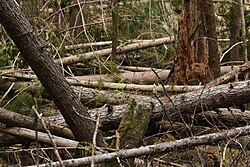
Large woody debris (LWD) are the logs, sticks, branches, and other wood that falls into streams and rivers. This debris can influence the flow and the shape of the stream channel. Large woody debris, grains, and the shape of the bed of the stream are the three main providers of flow resistance, and are thus, a major influence on the shape of the stream channel. [1] Some stream channels have less LWD than they would naturally because of removal by watershed managers for flood control and aesthetic reasons. [2]

Contents

The study of woody debris is important for its forestry management implications. Plantation thinning can reduce the potential for recruitment of LWD into proximal streams. The presence of large woody debris is important in the formation of pools which serve as salmon habitat in the Pacific Northwest. [3] Entrainment of the large woody debris in a stream can also cause erosion and scouring around and under the LWD. The amount of scouring and erosion is determined by the ratio of the diameter of the piece, to the depth of the stream, and the embedding and orientation of the piece.[ citation needed ]

Large woody debris helps to form pools in streams, which are important habitats for fish and other species. Upper Lehman Creek.jpg
Large woody debris helps to form pools in streams, which are important habitats for fish and other species.

Influence on stream flow around bends

Large woody debris slow the flow through a bend in the stream, while accelerating flow in the constricted area downstream of the obstruction. [4]

See also

Related Research Articles

<span class="mw-page-title-main">Erosion</span> Natural processes that remove soil and rock

Erosion is the action of surface processes that removes soil, rock, or dissolved material from one location on the Earth's crust and then transports it to another location where it is deposited. Erosion is distinct from weathering which involves no movement. Removal of rock or soil as clastic sediment is referred to as physical or mechanical erosion; this contrasts with chemical erosion, where soil or rock material is removed from an area by dissolution. Eroded sediment or solutes may be transported just a few millimetres, or for thousands of kilometres.

<span class="mw-page-title-main">Stream bed</span> Channel bottom of a stream, river, or creek

A stream bed or streambed is the bottom of a stream or river (bathymetry) or the physical confine of the normal water flow (channel). The lateral confines or channel margins are known as the stream banks or river banks, during all but flood stage. Under certain conditions a river can branch from one stream bed to multiple stream beds. A flood occurs when a stream overflows its banks and flows onto its flood plain. As a general rule, the bed is the part of the channel up to the normal water line, and the banks are that part above the normal water line. However, because water flow varies, this differentiation is subject to local interpretation. Usually, the bed is kept clear of terrestrial vegetation, whereas the banks are subjected to water flow only during unusual or perhaps infrequent high water stages and therefore might support vegetation some or much of the time.

<span class="mw-page-title-main">Culvert</span> Structure that allows the passage of water or organisms under an obstruction

A culvert is a structure that channels water past an obstacle or to a subterranean waterway. Typically embedded so as to be surrounded by soil, a culvert may be made from a pipe, reinforced concrete or other material. In the United Kingdom, the word can also be used for a longer artificially buried watercourse.

<span class="mw-page-title-main">Snag (ecology)</span> Dead tree

In forest ecology, a snag refers to a standing, dead or dying tree, often missing a top or most of the smaller branches. In freshwater ecology it refers to trees, branches, and other pieces of naturally occurring wood found sunken in rivers and streams; it is also known as coarse woody debris. When used in manufacturing, especially in Scandinavia, they are often called dead wood and in Finland, kelo wood.

<span class="mw-page-title-main">Meander</span> One of a series of curves in a channel of a matured stream

A meander is one of a series of regular sinuous curves in the channel of a river or other watercourse. It is produced as a watercourse erodes the sediments of an outer, concave bank and deposits sediments on an inner, convex bank which is typically a point bar. The result of this coupled erosion and sedimentation is the formation of a sinuous course as the channel migrates back and forth across the axis of a floodplain.

<span class="mw-page-title-main">River engineering</span> Study of human intervention in the course, characteristics, or flow of rivers

River engineering is a discipline of civil engineering which studies human intervention in the course, characteristics, or flow of a river with the intention of producing some defined benefit. People have intervened in the natural course and behaviour of rivers since before recorded history—to manage the water resources, to protect against flooding, or to make passage along or across rivers easier. Since the Yuan Dynasty and Ancient Roman times, rivers have been used as a source of hydropower. From the late 20th century, the practice of river engineering has responded to environmental concerns broader than immediate human benefit. Some river engineering projects have focused exclusively on the restoration or protection of natural characteristics and habitats.

<span class="mw-page-title-main">Mattole River</span> River in the United States of America

The Mattole River is a river on the north coast of California, that flows northerly, then westerly into the Pacific Ocean. The vast majority of its 62 miles (100 km) course is through southern Humboldt County, though a short section of the river flows through northern Mendocino County. Communities, from north to south, closely associated with the Mattole River include: Petrolia, Honeydew, Ettersburg, Thorn Junction, and Whitethorn. The river enters the ocean at the Mattole Estuary about 4 miles (6.4 km) west-southwest of Petrolia and 10 miles (16 km) south of Cape Mendocino.

Management of Pacific Northwest riparian forests is necessary because many of these forests have been dramatically changed from their original makeup. The primary interest in riparian forest and aquatic ecosystems under the Northwest Forest Plan (NWFP) is the need to restore stream habitat for fish populations, particularly anadromous salmonids. Some of these forests have been grazed by cattle or other livestock. The heavy hooves of these animals compact the soil. This compaction does not allow the water to be absorbed into the ground, so the water runs off into the stream carrying topsoil along the way.

<span class="mw-page-title-main">Point bar</span> Landform related to streams and rivers

A point bar is a depositional feature made of alluvium that accumulates on the inside bend of streams and rivers below the slip-off slope. Point bars are found in abundance in mature or meandering streams. They are crescent-shaped and located on the inside of a stream bend, being very similar to, though often smaller than, towheads, or river islands.

<span class="mw-page-title-main">Stream restoration</span>

Stream restoration or river restoration, also sometimes referred to as river reclamation, is work conducted to improve the environmental health of a river or stream, in support of biodiversity, recreation, flood management and/or landscape development.

<span class="mw-page-title-main">Log jam</span> Accumulation of large wood in a stream or river, preventing movement downstream

A log jam is a naturally occurring phenomenon characterized by a dense accumulation of tree trunks and pieces of large wood across a vast section of a river, stream, or lake. Log jams in rivers and streams often span the entirety of the water's surface from bank to bank. Log jams form when trees floating in the water become entangled with other trees floating in the water, or become snagged on rocks, large woody debris, or other objects anchored underwater. They can build up slowly over months or years, or they can happen instantaneously when large numbers of trees are swept into the water after natural disasters. A notable example caused by a natural disaster is the log jam that occurred in Spirit Lake following a landslide triggered by the eruption of Mount St. Helens. Until they are dismantled by natural causes or humans, log jams can grow exponentially as more wood arriving from upstream becomes entangled in the mass. Log jams can persist for many decades, as is the case with the log jam in Spirit Lake.

<span class="mw-page-title-main">Avulsion (river)</span> Rapid abandonment of a river channel and formation of a new channel

In sedimentary geology and fluvial geomorphology, avulsion is the rapid abandonment of a river channel and the formation of a new river channel. Avulsions occur as a result of channel slopes that are much less steep than the slope that the river could travel if it took a new course.

<span class="mw-page-title-main">Bridge scour</span> Removal of sediment from around bridge abutments or piers by the movement of water

Bridge scour is the removal of sediment such as sand and gravel from around bridge abutments or piers. Hydrodynamic scour, caused by fast flowing water, can carve out scour holes, compromising the integrity of a structure.

<span class="mw-page-title-main">Check dam</span> Small dam to counteract erosion

A check dam is a small, sometimes temporary, dam constructed across a swale, drainage ditch, or waterway to counteract erosion by reducing water flow velocity. Check dams themselves are not a type of new technology; rather, they are an ancient technique dating from the second century A.D. Check dams are typically, though not always, implemented in a system of several dams situated at regular intervals across the area of interest.

<span class="mw-page-title-main">Alluvial river</span> Type of river

An alluvial river is one in which the bed and banks are made up of mobile sediment and/or soil. Alluvial rivers are self-formed, meaning that their channels are shaped by the magnitude and frequency of the floods that they experience, and the ability of these floods to erode, deposit, and transport sediment. For this reason, alluvial rivers can assume a number of forms based on the properties of their banks; the flows they experience; the local riparian ecology; and the amount, size, and type of sediment that they carry.

<span class="mw-page-title-main">Bank erosion</span> Marginal wear of a watercourse

Bank erosion is the wearing away of the banks of a stream or river. This is distinguished from erosion of the bed of the watercourse, which is referred to as scour.

<span class="mw-page-title-main">Meander cutoff</span>

A meander cutoff is a natural form of a cutting or cut in a river occurs when a pronounced meander (hook) in a river is breached by a flow that connects the two closest parts of the hook to form a new channel, a full loop. The steeper drop in gradient (slope) causes the river flow gradually to abandon the meander which will silt up with sediment from deposition. Cutoffs are a natural part of the evolution of a meandering river. Rivers form meanders as they flow laterally downstream, see sinuosity.

<span class="mw-page-title-main">River incision</span>

River incision is the narrow erosion caused by a river or stream that is far from its base level. River incision is common after tectonic uplift of the landscape. Incision by multiple rivers result in a dissected landscape, for example a dissected plateau. River incision is the natural process by which a river cuts downward into its bed, deepening the active channel. Though it is a natural process, it can be accelerated rapidly by human factors including land use changes such as timber harvest, mining, agriculture, and road and dam construction. The rate of incision is a function of basal shear-stress. Shear stress is increased by factors such as sediment in the water, which increase its density. Shear stress is proportional to water mass, gravity, and WSS:

Legacy sediment (LS) is depositional bodies of sediment inherited from the increase of human activities since the Neolithic. These include a broad range of land use and land cover changes, such as agricultural clearance, lumbering and clearance of native vegetation, mining, road building, urbanization, as well as alterations brought to river systems in the form of dams and other engineering structures meant to control and regulate natural fluvial processes (erosion, deposition, lateral migration, meandering). The concept of LS is used in geomorphology, ecology, as well as in water quality and toxicological studies.

The Maybeso Experimental Forest is an experimental forest on Prince of Wales Island in Alaska. It is located near Hollis, Alaska within the Tongass National Forest and is administered by the United States Forest Service. The area of the forest is approximately 1,101 acres (446 ha), with a peak elevation of 2,953 feet (900 m). The forest was established in 1956 to examine the effects of large-scale clearcut timber harvesting on forest regeneration and anadromous salmonid spawning areas. The Maybeso Experimental Forest is the site of the first large-scale clearcut logging operation in Southeast Alaska, and nearly all commercial forest was removed from the area between 1953 and 1960. Presently, the forest is an even-aged, second-growth Sitka spruce and Western hemlock forest.

References

  1. Curran, Janet H. "Flow Resistance of Large Woody Debris in Headwater Streams of the Washington Cascades" Abstracts with Programs - Geological Society of America, vol.29, no.6, pp.315, 1997
  2. Lawrence, J.E., V.H. Resh, and M.R. Cover (2014). "Large-wood Loading from Natural and Engineered Processes at the Watershed Scale". River Research and Applications. 29 (8): 1030–1041. doi:10.1002/rra.2589. S2CID   129433335.{{cite journal}}: CS1 maint: multiple names: authors list (link)
  3. "Engineered Log Jams - Elwha Watershed Information Resource". Archived from the original on 23 December 2008.
  4. Daniels, Melinda D; Rhoads, Bruce L "Influence of experimental removal of large woody debris on spatial patterns of three-dimensional flow in a meander bend" Earth Surface Processes and Landforms , vol.32, no.3, pp.460-474, Mar 2007