Siltation

Last updated
Siltation of a waterway Siltation or Sedimentation.jpg
Siltation of a waterway

Siltation is water pollution caused by particulate terrestrial clastic material, with a particle size dominated by silt or clay. It refers both to the increased concentration of suspended sediments and to the increased accumulation (temporary or permanent) of fine sediments on bottoms where they are undesirable. Siltation is most often caused by soil erosion or sediment spill.

Contents

It is sometimes referred to by the ambiguous term "sediment pollution", which can also refer to a chemical contamination of sediments accumulated on the bottom, or to pollutants bound to sediment particles. Although "siltation" is not perfectly stringent, since it also includes particle sizes other than silt, it is preferred for its lack of ambiguity.

Causes

Siltation caused by fecal sludge collected from pit latrines and dumped into a river at the Korogocho slum in Nairobi, Kenya. Dumping of faecal sludge into the river.jpg
Siltation caused by fecal sludge collected from pit latrines and dumped into a river at the Korogocho slum in Nairobi, Kenya.
Siltation caused by raw sewage sludge and industrial waste in the New River as it passes from Mexicali to Calexico, California. Nrborderborderentrythreecolorsmay05-1-.JPG
Siltation caused by raw sewage sludge and industrial waste in the New River as it passes from Mexicali to Calexico, California.
Siltation caused by sewage sludge from shipyard in Rio de Janeiro. Jacuecanga Angra dos Reis Rio de Janeiro Brazil Brasfels.JPG
Siltation caused by sewage sludge from shipyard in Rio de Janeiro.

The origin of the increased sediment transport into an area may be erosion on land or activities in the water.

In rural areas, the erosion source is typically soil degradation by intensive or inadequate agricultural practices, leading to soil erosion, especially in fine-grained soils such as loess. The result will be an increased amount of silt and clay in the water bodies that drain the area. In urban areas, the erosion source is typically construction activities, which involve clearing the original land-covering vegetation and temporarily creating something akin to an urban desert from which fines are easily washed out during rainstorms.

In water, the main pollution source is sediment spill from dredging, the transportation of dredged material on barges, and the deposition of dredged material in or near water. Such deposition may be made to get rid of unwanted material, such as the offshore dumping of material dredged from harbours and navigation channels. The deposition may also be to build up the coastline, for artificial islands, or for beach replenishment.

Climate change also affects siltation rates. [1]

Another important cause of siltation is the septage and other sewage sludges that are discharged from households or business establishments with no septic tanks or wastewater treatment facilities to bodies of water.

Vulnerabilities

Silted river polluted by sediment. Muddy USGS.jpg
Silted river polluted by sediment.

While the sediment in transport is in suspension, it acts as a pollutant for those who require clean water, such as for cooling or in industrial processes, and it includes aquatic life that are sensitive to suspended material in the water. While nekton have been found to avoid spill plumes in the water (e.g. the environmental monitoring project during the building of the Øresund Bridge), filtering benthic organisms have no way of escape. Among the most sensitive organisms are coral polyps. Generally speaking, hard bottom communities and mussel banks (including oysters) are more sensitive to siltation than sand and mud bottoms. Unlike in the sea, in a stream, the plume will cover the entire channel, except possibly for backwaters, and so fish will also be directly affected in most cases.

Siltation can also affect navigation channels or irrigation channels. It refers to the undesired accumulation of sediments in channels intended for vessels or for distributing water.

Measurement and monitoring

A sensor for measuring siltation in situ. SediMeter sensor.jpg
A sensor for measuring siltation in situ.

One may distinguish between measurements at the source, during transport, and within the affected area. Source measurements of erosion may be very difficult since the lost material may be a fraction of a millimeter per year. Therefore, the approach taken is typically to measure the sediment in transport in the stream, by measuring the sediment concentration and multiplying that with the discharge; for example, 50 mg/L (1.8×10⁻⁶ lb/cu in) times 30 m3/s (1,100 cu ft/s) gives 1.5 kg/s (200 lb/min).

Also, sediment spill is better measured in transport than at the source. The sediment transport in open water is estimated by measuring the turbidity, correlating turbidity to sediment concentration (using a regression developed from water samples that are filtered, dried, and weighed), multiplying the concentration with the discharge as above, and integrating over the entire plume. To distinguish the spill contribution, the background turbidity is subtracted from the spill plume turbidity. Since the spill plume in open water varies in space and time, an integration over the entire plume is required, and repeated many times to get acceptably low uncertainty in the results. The measurements are made close to the source, in the order of a few hundred meters.

Anything beyond a work area buffer zone for sediment spill is considered the potential impact area. In the open sea, the impact of concern is almost exclusively with the sessile bottom communities since empirical data show that fish effectively avoid the impacted area. The siltation affects the bottom community in two main ways. The suspended sediment may interfere with the food gathering of filtering organisms, and the sediment accumulation on the bottom may bury organisms to the point that they starve or even die. It is only if the concentration is extreme that it decreases the light level sufficiently for impacting primary productivity. An accumulation of as little as 1 mm (0.039 in) may kill coral polyps.

While the effect of the siltation on the biota (once the harm is already done) can be studied by repeated inspection of selected test plots, the magnitude of the siltation process in the impact area may be measured directly by monitoring in real time. Parameters to measure are sediment accumulation, turbidity at the level of the filtering biota, and optionally incident light. [2]

Siltation of the magnitude that it affects shipping can also be monitored by repeated bathymetric surveys.

Mitigation

Resuspension of fines from a replenished beach causing siltation offshore Key Biscayne Crandon Park beach.jpg
Resuspension of fines from a replenished beach causing siltation offshore

In rural areas, the first line of defense is to maintain land cover and prevent soil erosion in the first place. The second line of defense is to trap the material before it reaches the stream network (known as sediment control). In urban areas, the defenses are to keep land uncovered for as short a time as possible during construction and to use silt screens to prevent the sediment from getting released in water bodies.

During dredging, the spill can be minimized but not eliminated completely by the way the dredger is designed and operated. If the material is deposited on land, efficient sedimentation basins can be constructed. If it is dumped into relatively deep water, there will be a significant spill during dumping but not thereafter, and the spill that arises has minimal impact if there are only fine-sediment bottoms nearby.

One of the most difficult conflicts of interest to resolve, as regards siltation mitigation, is perhaps beach nourishment. When sediments are placed on or near beaches in order to replenish an eroding beach, any fines in the material will continue to be washed out for as long as the sand is being reworked. Since all replenished beaches are eroding or they would not need replenishment, they will contribute to nearshore siltation almost for as long as it takes to erode away what was added, albeit with somewhat decreasing intensity over time. Since the leakage is detrimental to coral reefs, the practice leads to a direct conflict between the public interest of saving beaches, and preserving any nearshore coral reefs. To minimize the conflict, beach replenishment should not be done with sand containing any silt or clay fractions. In practice the sand is often taken from offshore areas, and since the proportion of fines in sediments typically increases in the offshore direction, the deposited sand will inevitably contain a significant percentage of siltation-contributing fines.

It is desirable to minimize the siltation of irrigation channels by hydrologic design, the objective being not to create zones with falling sediment transport capacity, as that is conducive to sedimentation. Once sedimentation has occurred, in irrigation or navigation channels, dredging is often the only remedy.

Related Research Articles

<span class="mw-page-title-main">Erosion</span> Natural processes that remove soil and rock

Erosion is the action of surface processes that removes soil, rock, or dissolved material from one location on the Earth's crust and then transports it to another location where it is deposited. Erosion is distinct from weathering which involves no movement. Removal of rock or soil as clastic sediment is referred to as physical or mechanical erosion; this contrasts with chemical erosion, where soil or rock material is removed from an area by dissolution. Eroded sediment or solutes may be transported just a few millimetres, or for thousands of kilometres.

<span class="mw-page-title-main">Beach</span> Area of loose particles at the edge of the sea or other body of water

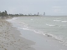
A beach is a landform alongside a body of water which consists of loose particles. The particles composing a beach are typically made from rock, such as sand, gravel, shingle, pebbles, etc., or biological sources, such as mollusc shells or coralline algae. Sediments settle in different densities and structures, depending on the local wave action and weather, creating different textures, colors and gradients or layers of material.

<span class="mw-page-title-main">Sedimentary rock</span> Rock formed by the deposition and cementation of particles

Sedimentary rocks are types of rock that are formed by the accumulation or deposition of mineral or organic particles at Earth's surface, followed by cementation. Sedimentation is the collective name for processes that cause these particles to settle in place. The particles that form a sedimentary rock are called sediment, and may be composed of geological detritus (minerals) or biological detritus. The geological detritus originated from weathering and erosion of existing rocks, or from the solidification of molten lava blobs erupted by volcanoes. The geological detritus is transported to the place of deposition by water, wind, ice or mass movement, which are called agents of denudation. Biological detritus was formed by bodies and parts of dead aquatic organisms, as well as their fecal mass, suspended in water and slowly piling up on the floor of water bodies. Sedimentation may also occur as dissolved minerals precipitate from water solution.

<span class="mw-page-title-main">Sediment</span> Particulate solid matter that is deposited on the surface of land

Sediment is a naturally occurring material that is broken down by processes of weathering and erosion, and is subsequently transported by the action of wind, water, or ice or by the force of gravity acting on the particles. For example, sand and silt can be carried in suspension in river water and on reaching the sea bed deposited by sedimentation; if buried, they may eventually become sandstone and siltstone through lithification.

<span class="mw-page-title-main">Shoal</span> Natural submerged sandbank that rises from a body of water to near the surface

In oceanography, geomorphology, and geoscience, a shoal is a natural submerged ridge, bank, or bar that consists of, or is covered by, sand or other unconsolidated material, and rises from the bed of a body of water close to the surface or above it, which poses a danger to navigation. Shoals are also known as sandbanks, sandbars, or gravelbars. Two or more shoals that are either separated by shared troughs or interconnected by past or present sedimentary and hydrographic processes are referred to as a shoal complex.

<span class="mw-page-title-main">Channel (geography)</span> Type of landform in which part of a body of water is confined to a relatively narrow but long region

In physical geography and hydrology, a channel is a landform on which a relatively narrow body of water is situated, such as a river, river delta or strait. While channel typically refers to a natural formation, the cognate term canal denotes a similar artificial structure.

<span class="mw-page-title-main">Sedimentation</span> Tendency for particles in suspension to settle down

Sedimentation is the deposition of sediments. It takes place when particles in suspension settle out of the fluid in which they are entrained and come to rest against a barrier. This is due to their motion through the fluid in response to the forces acting on them: these forces can be due to gravity, centrifugal acceleration, or electromagnetism. Settling is the falling of suspended particles through the liquid, whereas sedimentation is the final result of the settling process.

<span class="mw-page-title-main">Dredging</span> Excavation of sediment, usually under water

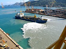
Dredging is the excavation of material from a water environment. Possible reasons for dredging include improving existing water features; reshaping land and water features to alter drainage, navigability, and commercial use; constructing dams, dikes, and other controls for streams and shorelines; and recovering valuable mineral deposits or marine life having commercial value. In all but a few situations the excavation is undertaken by a specialist floating plant, known as a dredger.

<span class="mw-page-title-main">Beach nourishment</span> Sediment replacement process

Beach nourishment describes a process by which sediment, usually sand, lost through longshore drift or erosion is replaced from other sources. A wider beach can reduce storm damage to coastal structures by dissipating energy across the surf zone, protecting upland structures and infrastructure from storm surges, tsunamis and unusually high tides. Beach nourishment is typically part of a larger integrated coastal zone management aimed at coastal defense. Nourishment is typically a repetitive process since it does not remove the physical forces that cause erosion but simply mitigates their effects.

<span class="mw-page-title-main">Seabed</span> The bottom of the ocean

The seabed is the bottom of the ocean. All floors of the ocean are known as 'seabeds'.

Parent material is the underlying geological material in which soil horizons form. Soils typically inherit a great deal of structure and minerals from their parent material, and, as such, are often classified based upon their contents of consolidated or unconsolidated mineral material that has undergone some degree of physical or chemical weathering and the mode by which the materials were most recently transported.

<span class="mw-page-title-main">Rainbowing</span>

Rainbowing is the process in which a dredging ship propels sand that has been claimed from the ocean floor in a high arc to a particular location. This is used for multiple purposes, ranging from building up a beach to prevent erosion to constructing new islands. The name is derived from the appearance of the arc, which closely resembles a brown-colored rainbow.

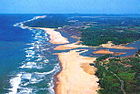
Beach evolution occurs at the shoreline where sea, lake or river water is eroding the land. Beaches exist where sand accumulated from centuries-old, recurrent processes that erode rocky and sedimentary material into sand deposits. River deltas deposit silt from upriver, accreting at the river's outlet to extend lake or ocean shorelines. Catastrophic events such as tsunamis, hurricanes, and storm surges accelerate beach erosion.

<span class="mw-page-title-main">Marine sediment</span>

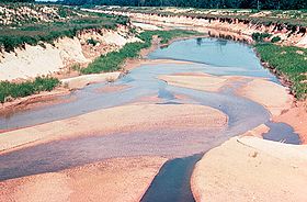
Marine sediment, or ocean sediment, or seafloor sediment, are deposits of insoluble particles that have accumulated on the seafloor. These particles either have their origins in soil and rocks and have been transported from the land to the sea, mainly by rivers but also by dust carried by wind and by the flow of glaciers into the sea, or they are biogenic deposits from marine organisms or from chemical precipitation in seawater, as well as from underwater volcanoes and meteorite debris.

<span class="mw-page-title-main">Silt fence</span> Sediment control device on construction sites

A silt fence, sometimes (misleadingly) called a "filter fence," is a temporary sediment control device used on construction sites to protect water quality in nearby streams, rivers, lakes and seas from sediment in stormwater runoff. Silt fences are widely used on construction sites in North America and elsewhere, due to their low cost and simple design. However, their effectiveness in controlling sediment can be limited, due to problems with poor installation, proper placement, and/or inadequate maintenance.

<span class="mw-page-title-main">Sand</span> Granular material composed of finely divided rock and mineral particles

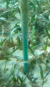
Sand is a granular material composed of finely divided mineral particles. Sand has various compositions but is defined by its grain size. Sand grains are smaller than gravel and coarser than silt. Sand can also refer to a textural class of soil or soil type; i.e., a soil containing more than 85 percent sand-sized particles by mass.

<span class="mw-page-title-main">Contourite</span> Type of sedimentary deposit

A contourite is a sedimentary deposit commonly formed on continental rise to lower slope settings, although they may occur anywhere that is below storm wave base. Countourites are produced by thermohaline-induced deepwater bottom currents and may be influenced by wind or tidal forces. The geomorphology of contourite deposits is mainly influenced by the deepwater bottom-current velocity, sediment supply, and seafloor topography.

In-Situ Capping (ISC) of Subaqueous Waste is a non-removal remediation technique for contaminated sediment that involves leaving the waste in place and isolating it from the environment by placing a layer of soil and/or material over the contaminated waste as to prevent further spread of the contaminant. In-situ capping provides a viable way to remediate an area that is contaminated. It is an option when pump and treat becomes too expensive and the area surrounding the site is a low energy system. The design of the cap and the characterization of the surrounding areas are of equal importance and drive the feasibility of the entire project. Numerous successful cases exist and more will exist in the future as the technology expands and grows more popular. In-situ capping uses techniques developed in chemistry, biology, geotechnical engineering, environmental engineering, and environmental geotechnical engineering.

<span class="mw-page-title-main">Marine habitat</span> Habitat that supports marine life

A marine habitat is a habitat that supports marine life. Marine life depends in some way on the saltwater that is in the sea. A habitat is an ecological or environmental area inhabited by one or more living species. The marine environment supports many kinds of these habitats.

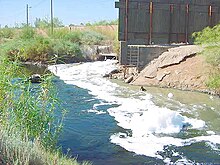
A dredge plume is a cloud of debris that forms as a result of dredging. Such plumes usually begin either at the bottom where the dredging takes place, or at the surface from either overflow from the dredging equipment or dumping of the dredged material in a different location.

References

  1. U.D. Kulkarni; et al. "The International Journal of Climate Change: Impacts and Responses » Rate of Siltation in Wular Lake, (Jammu and Kashmir, India) with Special Emphasis on its Climate & Tectonics". The International Journal of Climate Change: Impacts and Responses. Retrieved 2009-11-16.
  2. Siltation Monitoring Plan excerpt, retrieved 2010-07-11, http://lindorm.com/beaches/sedmon2.php