Stream pool

Last updated
A deep turquoise color of a stream pool on the Piva river. Piva.River-bridge.JPG
A deep turquoise color of a stream pool on the Piva river.

A stream pool, in hydrology, is a stretch of a river or stream in which the water depth is above average and the water velocity is below average. [1]

Contents

Formation

Stream pool formation. Kolkschema.svg
Stream pool formation.

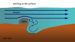
A stream pool may be bedded with sediment or armoured with gravel, and in some cases the pool formations may have been formed as basins in exposed bedrock formations. Plunge pools, or plunge basins, are stream pools formed by the action of waterfalls. Pools are often formed on the outside of a bend in a meandering river. [2]

Dynamics

The depth and lack of water velocity often leads to stratification in stream pools, especially in warmer regions. In warm arid regions of the Western United States, surface waters were found to be 3-9 °C higher than those at the bottom [3]

Habitat

This portion of a stream often provides a specialized aquatic ecosystem habitat for organisms that have difficulty feeding or navigating in swifter reaches of the stream or in seasonally warmer water. Such pools can be important for fish habitat, especially where many streams reach high summer temperatures and very low-flow dry season characteristics. In warm and arid regions, the stratification of stream pools provide cooler water for fish that prefer low water temperatures such as the redband trout (Oncorhynchus mykiss) in the Western United States. [4] Mosquito larvae, which prefer still and often stagnant water, can be found in stream pools due to the low water velocity. [5]

See also

Notes

  1. Matthew Chasse, Riffle characteristics in stream investigations Archived 2007-11-01 at the Wayback Machine
  2. http://mostreamteam.org/assets/habitat.pdf [ bare URL PDF ]
  3. Nielsen, Jennifer L.; Lisle, Thomas E.; Ozaki, Vicki (July 1994). "Thermally Stratified Pools and Their Use by Steelhead in Northern California Streams". Transactions of the American Fisheries Society. 123 (4): 613–626. doi:10.1577/1548-8659(1994)123<0613:tspatu>2.3.co;2. ISSN   0002-8487.
  4. tate, kenneth W.; lancaster, donald L.; lile, david. F. (January 2007). "Assessment of thermal stratification within stream pools as a mechanism to provide refugia for native trout in hot, arid rangelands". Environmental Monitoring and Assessment. 124 (1–3): 289–300. doi:10.1007/s10661-006-9226-5. ISSN   0167-6369. PMID   16897516. S2CID   21301944.
  5. Anbalagan, S.; Arunprasanna, V.; Kannan, M.; Dinakaran, S.; Krishnan, M. (1 December 2015). "Spatio-temporal dynamics of mosquitoes in stream pools of a biosphere reserve of Southern Western Ghats, India". Acta Tropica. 152: 228–236. doi:10.1016/j.actatropica.2015.09.024. PMID   26434940.

Related Research Articles

<span class="mw-page-title-main">Trout</span> Freshwater fish from subfamily Salmoninae

Trout is a generic common name for numerous species of carnivorous freshwater ray-finned fishes belonging to the genera Oncorhynchus, Salmo and Salvelinus, all of which are members of the subfamily Salmoninae in the family Salmonidae. The word trout is also used for some similar-shaped but non-salmonid fish, such as the spotted seatrout/speckled trout.

<span class="mw-page-title-main">Limnology</span> Science of inland aquatic ecosystems

Limnology is the study of inland aquatic ecosystems. The study of limnology includes aspects of the biological, chemical, physical, and geological characteristics of fresh and saline, natural and man-made bodies of water. This includes the study of lakes, reservoirs, ponds, rivers, springs, streams, wetlands, and groundwater. Water systems are often categorized as either running (lotic) or standing (lentic).

<span class="mw-page-title-main">Fluvial processes</span> Processes associated with rivers and streams

In geography and geology, fluvial processes are associated with rivers and streams and the deposits and landforms created by them. When the stream or rivers are associated with glaciers, ice sheets, or ice caps, the term glaciofluvial or fluvioglacial is used.

<span class="mw-page-title-main">Snowy River</span> River in south-eastern Australia

The Snowy River is a major river in south-eastern Australia. It originates on the slopes of Mount Kosciuszko, Australia's highest mainland peak, draining the eastern slopes of the Snowy Mountains in New South Wales, before flowing through the Alpine National Park and the Snowy River National Park in Victoria and emptying into Bass Strait.

<span class="mw-page-title-main">Lake stratification</span> Separation of water in a lake into distinct layers

Lake stratification is the tendency of lakes to form separate and distinct thermal layers during warm weather. Typically stratified lakes show three distinct layers, the epilimnion comprising the top warm layer, the thermocline : the middle layer, which may change depth throughout the day, and the colder hypolimnion extending to the floor of the lake.

<span class="mw-page-title-main">Sauger</span> Species of fish

The sauger is a freshwater perciform fish of the family Percidae that resembles its close relative, the walleye. The species is a member of the largest vertebrate order, the Perciformes. It is the most migratory percid species in North America. Saugers have two dorsal fins; the first is spiny and the posterior dorsal fin is soft-rayed. Their paired fins are in the thoracic position and their caudal fin is truncated, which means squared off at the corners, a characteristic of the family Percidae. Another physical characteristic of saugers is their ctenoid scales, which are common in advanced fishes. Saugers have a fusiform body structure, and as a result are well adapted predatory fishes and are capable of swimming into fast currents with minimal drag on their bodies. They may be distinguished from walleyes by the distinctly spotted dorsal fin, by the lack of a white splotch on the caudal fin, by the rough skin over their gills, and by their generally more brassy color, or darker color in some regions. The typical sauger is 300 to 400 g in weight.

<span class="mw-page-title-main">Yakhchāl</span> Ancient Persian ice-house

A yakhchāl is an ancient type of ice house, which also made ice. They primarily found in the Dasht-e Lut and Dasht-e-Kavir deserts, whose climates range from cold (BWk) to hot (BWh) desert regions.

<span class="mw-page-title-main">Water feature</span> Artificial construct that prominently displays water for decorative purposes

In landscape architecture and garden design, a water feature is one or more items from a range of fountains, jeux d'eau, pools, ponds, rills, artificial waterfalls, and streams. Before the 18th century they were usually powered by gravity, though the famous Hanging Gardens of Babylon are described by Strabo as supplied by an Archimedean screw and other examples were supplied with water using hydraulic rams.

<span class="mw-page-title-main">River engineering</span> Study of human intervention in the course, characteristics, or flow of rivers

River engineering is a discipline of civil engineering which studies human intervention in the course, characteristics, or flow of a river with the intention of producing some defined benefit. People have intervened in the natural course and behaviour of rivers since before recorded history—to manage the water resources, to protect against flooding, or to make passage along or across rivers easier. Since the Yuan Dynasty and Ancient Roman times, rivers have been used as a source of hydropower. From the late 20th century, the practice of river engineering has responded to environmental concerns broader than immediate human benefit. Some river engineering projects have focused exclusively on the restoration or protection of natural characteristics and habitats.

<span class="mw-page-title-main">Plunge pool</span> Depression at the base of a waterfall

A plunge pool is a deep depression in a stream bed at the base of a waterfall or shut-in. It is created by the erosional forces of cascading water on the rocks at formation's base where the water impacts. The term may refer to the water occupying the depression, or the depression itself.

<span class="mw-page-title-main">Mixed layer</span> Layer in which active turbulence has homogenized some range of depths

The oceanic or limnological mixed layer is a layer in which active turbulence has homogenized some range of depths. The surface mixed layer is a layer where this turbulence is generated by winds, surface heat fluxes, or processes such as evaporation or sea ice formation which result in an increase in salinity. The atmospheric mixed layer is a zone having nearly constant potential temperature and specific humidity with height. The depth of the atmospheric mixed layer is known as the mixing height. Turbulence typically plays a role in the formation of fluid mixed layers.

<span class="mw-page-title-main">Riffle</span> Shallow landform in a flowing channel

A riffle is a shallow landform in a flowing channel. Colloquially, it is a shallow place in a river where water flows quickly past rocks. However, in geology a riffle has specific characteristics.

<span class="mw-page-title-main">Perennial stream</span> Type of river

A perennial stream is a stream that has continuous flow of surface water throughout the year in at least parts of its catchment during seasons of normal rainfall, as opposed to one whose flow is intermittent. In the absence of irregular, prolonged or extreme drought, a perennial stream is a watercourse, or segment, element or emerging body of water which continually delivers groundwater. For example, an artificial disruption of stream, variability in flow or stream selection associated with the activity in hydropower installations, do not affect this status. Perennial streams do not include stagnant water, reservoirs, cutoff lakes and ponds that persist throughout the year. All other streams, or parts of them, should be considered seasonal rivers or lakes. The stream can cycle from intermittent to perpetual through multiple iterations.

<span class="mw-page-title-main">Drop structure</span> Structure that lowers elevation of water in a controlled fashion

A drop structure, also known as a grade control, sill, or weir, is a manmade structure, typically small and built on minor streams, or as part of a dam's spillway, to pass water to a lower elevation while controlling the energy and velocity of the water as it passes over. Unlike most dams, drop structures are usually not built for water impoundment, diversion or raising the water level. Mostly built on watercourses with steep gradients, they serve other purposes such as water oxygenation and erosion prevention.

<span class="mw-page-title-main">Pond</span> Relatively small body of standing water

A pond is a small, still, land-based body of water formed by pooling inside a depression, either naturally or artificially. A pond is smaller than a lake and there are no official criteria distinguishing the two, although defining a pond to be less than 5 hectares in area, less than 5 metres (16 ft) in depth and with less than 30% with emergent vegetation helps in distinguishing the ecology of ponds from those of lakes and wetlands. Ponds can be created by a wide variety of natural processes, or they can simply be isolated depressions filled by runoff, groundwater, or precipitation, or all three of these. They can be further divided into four zones: vegetation zone, open water, bottom mud and surface film. The size and depth of ponds often varies greatly with the time of year; many ponds are produced by spring flooding from rivers. Ponds may be freshwater or brackish in nature. 'Ponds' with saltwater, with a direct connection to the sea that maintains full salinity, would normally be regarded as part of the marine environment because they would not support fresh or brackish water organisms, so not really within the realm of freshwater science.

<span class="mw-page-title-main">River</span> Natural flowing watercourse

A river is a natural flowing watercourse, usually freshwater stream, flowing on the surface or inside caves towards another waterbody at a lower elevation, such as an ocean, sea, bay, lake, wetland, or another river. In some cases, a river flows into the ground or becomes dry at the end of its course without reaching another body of water. Small rivers can be referred to using names such as creek, brook, and rivulet. There are no official definitions for the generic term river as applied to geographic features, although in some countries or communities, a stream is defined by its size. Many names for small rivers are specific to geographic location; examples are "run" in some parts of the United States, "burn" in Scotland and Northeast England, and "beck" in Northern England. Sometimes a river is defined as being larger than a creek, but not always: the language is vague.

<span class="mw-page-title-main">Lake</span> Large body of relatively still water

A lake is a naturally occurring, relatively large body of water localized in a basin surrounded by dry land. A lake generally has a slower-moving flow than the inflow or outflow stream(s) that serve to feed or drain it. Lakes lie completely on land and are separate from the ocean, although, like the much larger oceans, they form part of the Earth's water cycle by serving as large standing pools of storage water. Most lakes are freshwater and account for almost all the world's surface freshwater, but some are salt lakes with salinities even higher than that of seawater.

<span class="mw-page-title-main">Headwater chub</span> Species of fish

The headwater chub is a species of fish in the family Cyprinidae. It is found in Arizona and New Mexico.

<span class="mw-page-title-main">Macroinvertebrate Community Index</span> An indicator of water quality and overall stream health

Macroinvertebrate Community Index (MCI) is an index used in New Zealand to measure the water quality of fresh water streams. The presence or lack of macroinvertebrates such as insects, worms and snails in a river or stream can give a biological indicator on the health of that waterway. The MCI assigns a number to each species of macroinvertebrate based on the sensitivity of that species to pollution. The index then calculates an average score. A higher score on the MCI generally indicates a more healthy stream.

An anchialine system is a landlocked body of water with a subterranean connection to the ocean. Depending on its formation, these systems can exist in one of two primary forms: pools or caves. The primary differentiating characteristics between pools and caves is the availability of light; cave systems are generally aphotic while pools are euphotic. The difference in light availability has a large influence on the biology of a given system. Anchialine systems are a feature of coastal aquifers which are density stratified, with water near the surface being fresh or brackish, and saline water intruding from the coast at depth. Depending on the site, it is sometimes possible to access the deeper saline water directly in the anchialine pool, or sometimes it may be accessible by cave diving.