
A seep or flush [1] is a moist or wet place where water, usually groundwater, reaches the Earth's surface from an underground aquifer.
A seep or flush [1] is a moist or wet place where water, usually groundwater, reaches the Earth's surface from an underground aquifer.
Seeps are usually not of sufficient volume to be flowing beyond their immediate above-ground location. They are part of the limnology-geomorphology system. Like a higher volume spring, the water is only from underground sources. Seeps mostly occur in lower elevation areas because water runs downhill, but can happen higher up if the groundwater present is abundant enough. Along with natural seeps, man made seeps can occur by digging anywhere where there is wet ground. This method can be useful for survival purposes and helps the local wildlife by adding another water source to the area.[ citation needed ]
Seeps often form a puddle, and are important for small wildlife, bird, and butterfly habitat and moisture needs. When they support mud-puddling, many butterfly (Lepidoptera) species, including some types that are endemic endangered species, can obtain nutrients such as salts and amino acids.[ citation needed ]
Seep is often used in environmental sciences to define an exfiltration zone (seepage zone) where contaminated water, e.g., from waste dumps, leaves a waste system area.
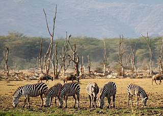
Seeps are often important smaller wildlife water sources, and indicated by lower riparian vegetation.
Seeps can also contribute to streams. If a stream is flowing below a water table then the stream receives contributions from the ground water via seepage. This allows drainage of the ground water and more substantial streamflow. The seep could be especially effective during a rainless period of the area, in which the seep can prolong the stream’s flow by adding water from the groundwater.

An aquifer is an underground layer of water-bearing material, consisting of permeable or fractured rock, or of unconsolidated materials. Aquifers vary greatly in their characteristics. The study of water flow in aquifers and the characterization of aquifers is called hydrogeology. Related terms include aquitard, which is a bed of low permeability along an aquifer, and aquiclude, which is a solid, impermeable area underlying or overlying an aquifer, the pressure of which could lead to the formation of a confined aquifer. The classification of aquifers is as follows: Saturated versus unsaturated; aquifers versus aquitards; confined versus unconfined; isotropic versus anisotropic; porous, karst, or fractured; transboundary aquifer.

Groundwater is the water present beneath Earth's surface in rock and soil pore spaces and in the fractures of rock formations. About 30 percent of all readily available fresh water in the world is groundwater. A unit of rock or an unconsolidated deposit is called an aquifer when it can yield a usable quantity of water. The depth at which soil pore spaces or fractures and voids in rock become completely saturated with water is called the water table. Groundwater is recharged from the surface; it may discharge from the surface naturally at springs and seeps, and can form oases or wetlands. Groundwater is also often withdrawn for agricultural, municipal, and industrial use by constructing and operating extraction wells. The study of the distribution and movement of groundwater is hydrogeology, also called groundwater hydrology.
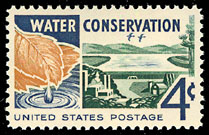
Water conservation aims to sustainably manage the natural resource of fresh water, protect the hydrosphere, and meet current and future human demand. Water conservation makes it possible to avoid water scarcity. It covers all the policies, strategies and activities to reach these aims. Population, household size and growth and affluence all affect how much water is used.

A water-meadow is an area of grassland subject to controlled irrigation to increase agricultural productivity. Water-meadows were mainly used in Europe from the 16th to the early 20th centuries. Working water-meadows have now largely disappeared, but the field patterns and water channels of derelict water-meadows remain common in areas where they were used, such as parts of Northern Italy, Switzerland and England. Derelict water-meadows are often of importance as wetland wildlife habitats.

The Edwards Aquifer is one of the most prolific artesian aquifers in the world. Located on the eastern edge of the Edwards Plateau in the U.S. state of Texas, it is the source of drinking water for two million people, and is the primary water supply for agriculture and industry in the aquifer's region. Additionally, the Edwards Aquifer feeds the Comal and San Marcos Springs, provides springflow for recreational and downstream uses in the Nueces, San Antonio, Guadalupe, and San Marcos river basins, and is home to several unique and endangered species.
Drainage density is a quantity used to describe physical parameters of a drainage basin. First described by Robert E. Horton, drainage density is defined as the total length of channel in a drainage basin divided by the total area, represented by the following equation:

A riparian zone or riparian area is the interface between land and a river or stream. In some regions, the terms riparian woodland, riparian forest, riparian buffer zone, riparian corridor, and riparian strip are used to characterize a riparian zone. The word riparian is derived from Latin ripa, meaning "river bank".
Lake Manyara National Park is a protected area in Tanzania's Arusha and Manyara Regions, situated between Lake Manyara and the Great Rift Valley. It is administered by the Tanzania National Parks Authority, and covers an area of 325 km2 (125 sq mi) including about 230 km2 (89 sq mi) lake surface. More than 350 bird species have been observed on the lake.

A puddle is a small accumulation of liquid, usually water, on a surface. It can form either by pooling in a depression on the surface, or by surface tension upon a flat surface. Puddles are often characterized by murky water or mud due to the disturbance and dissolving of surrounding sediment, primarily due to precipitation.
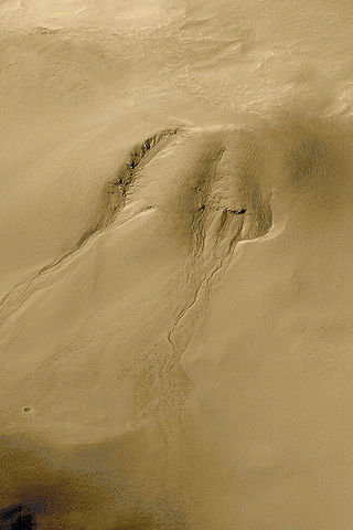
Groundwater sapping is a geomorphic erosion process that results in the headward migration of channels in response to near constant fluid discharge at a fixed point. The consistent flow of water displaces fine sediments which physically and chemically weathers rocks. Valleys that appear to have been created by groundwater sapping occur throughout the world in areas such as England, Colorado, Hawai’i, New Zealand, and many other places. However, it is difficult to characterize a landform as being formed exclusively by groundwater sapping due to phenomena such as pluvial runoff, plunge-pool undercutting, changes in water table level, and inconsistent groundwater flow. An example of drainage ways created purely by the outflow of subsurface fluids can be seen on the foreshores of beaches. As the surge of water and sand brought to land by a wave retreats seaward, the film of water becomes thinner until it forms rhomboid shaped patterns in the sand. Small fans form at the apex of the rhombic features, which are eventually fed by the remaining backflow of water traveling downslope. Channels begin to form headward in the form of millimeter wide rills along the sides of the fans; the creation of these small channel networks culminates when the last of the backwash dissipates.
Streamflow, or channel runoff, is the flow of water in streams and other channels, and is a major element of the water cycle. It is one runoff component, the movement of water from the land to waterbodies, the other component being surface runoff. Water flowing in channels comes from surface runoff from adjacent hillslopes, from groundwater flow out of the ground, and from water discharged from pipes. The discharge of water flowing in a channel is measured using stream gauges or can be estimated by the Manning equation. The record of flow over time is called a hydrograph. Flooding occurs when the volume of water exceeds the capacity of the channel.

Groundwater recharge or deep drainage or deep percolation is a hydrologic process, where water moves downward from surface water to groundwater. Recharge is the primary method through which water enters an aquifer. This process usually occurs in the vadose zone below plant roots and is often expressed as a flux to the water table surface. Groundwater recharge also encompasses water moving away from the water table farther into the saturated zone. Recharge occurs both naturally and through anthropogenic processes, where rainwater and/or reclaimed water is routed to the subsurface.

A sabkha is a coastal, supratidal mudflat or sandflat in which evaporite-saline minerals accumulate as the result of semiarid to arid climate. Sabkhas are gradational between land and intertidal zone within restricted coastal plains just above normal high-tide level. Within a sabkha, evaporite-saline minerals sediments typically accumulate below the surface of mudflats or sandflats. Evaporite-saline minerals, tidal-flood, and aeolian deposits characterize many sabkhas found along modern coastlines. The accepted type locality for a sabkha is at the southern coast of the Persian Gulf, in the United Arab Emirates. Evidence of clastic sabkhas are found in the geological record of many areas, including the UK and Ireland. Sabkha is a phonetic transliteration of the Arabic word used to describe any form of salt flat. A sabkha is also known as a sabkhah,sebkha, or coastal sabkha.
Subsurface flow, in hydrology, is the flow of water beneath Earth's surface as part of the water cycle.

A well is an excavation or structure created on the earth by digging, driving, or drilling to access liquid resources, usually water. The oldest and most common kind of well is a water well, to access groundwater in underground aquifers. The well water is drawn up by a pump, or using containers, such as buckets or large water bags that are raised mechanically or by hand. Water can also be injected back into the aquifer through the well. Wells were first constructed at least eight thousand years ago and historically vary in construction from a simple scoop in the sediment of a dry watercourse to the qanats of Iran, and the stepwells and sakiehs of India. Placing a lining in the well shaft helps create stability, and linings of wood or wickerwork date back at least as far as the Iron Age.
Groundwater remediation is the process that is used to treat polluted groundwater by removing the pollutants or converting them into harmless products. Groundwater is water present below the ground surface that saturates the pore space in the subsurface. Globally, between 25 per cent and 40 per cent of the world's drinking water is drawn from boreholes and dug wells. Groundwater is also used by farmers to irrigate crops and by industries to produce everyday goods. Most groundwater is clean, but groundwater can become polluted, or contaminated as a result of human activities or as a result of natural conditions.

Urban runoff is surface runoff of rainwater, landscape irrigation, and car washing created by urbanization. Impervious surfaces are constructed during land development. During rain, storms, and other precipitation events, these surfaces, along with rooftops, carry polluted stormwater to storm drains, instead of allowing the water to percolate through soil. This causes lowering of the water table and flooding since the amount of water that remains on the surface is greater. Most municipal storm sewer systems discharge untreated stormwater to streams, rivers, and bays. This excess water can also make its way into people's properties through basement backups and seepage through building wall and floors.

A stream is a continuous body of surface water flowing within the bed and banks of a channel. Depending on its location or certain characteristics, a stream may be referred to by a variety of local or regional names. Long, large streams are usually called rivers, while smaller, less voluminous and more intermittent streams are known as streamlets, brooks or creeks.

Freshwater biology is the scientific biological study of freshwater ecosystems and is a branch of limnology. This field seeks to understand the relationships between living organisms in their physical environment. These physical environments may include rivers, lakes, streams, ponds, reservoirs, or wetlands. Knowledge from this discipline is also widely used in industrial processes to make use of biological processes involved with sewage treatment and water purification. Water presence and flow is an essential aspect to species distribution and influences when and where species interact in freshwater environments.

Riparian-zone restoration is the ecological restoration of riparian-zonehabitats of streams, rivers, springs, lakes, floodplains, and other hydrologic ecologies. A riparian zone or riparian area is the interface between land and a river or stream. Riparian is also the proper nomenclature for one of the fifteen terrestrial biomes of the earth; the habitats of plant and animal communities along the margins and river banks are called riparian vegetation, characterized by aquatic plants and animals that favor them. Riparian zones are significant in ecology, environmental management, and civil engineering because of their role in soil conservation, their habitat biodiversity, and the influence they have on fauna and aquatic ecosystems, including grassland, woodland, wetland or sub-surface features such as water tables. In some regions the terms riparian woodland, riparian forest, riparian buffer zone, or riparian strip are used to characterize a riparian zone.
