Erosion is the action of surface processes that removes soil, rock, or dissolved material from one location on the Earth's crust and then transports it to another location where it is deposited. Erosion is distinct from weathering which involves no movement. Removal of rock or soil as clastic sediment is referred to as physical or mechanical erosion; this contrasts with chemical erosion, where soil or rock material is removed from an area by dissolution. Eroded sediment or solutes may be transported just a few millimetres, or for thousands of kilometres.
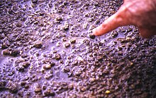
Soil erosion is the denudation or wearing away of the upper layer of soil. It is a form of soil degradation. This natural process is caused by the dynamic activity of erosive agents, that is, water, ice (glaciers), snow, air (wind), plants, and animals. In accordance with these agents, erosion is sometimes divided into water erosion, glacial erosion, snow erosion, wind (aeolian) erosion, zoogenic erosion and anthropogenic erosion such as tillage erosion. Soil erosion may be a slow process that continues relatively unnoticed, or it may occur at an alarming rate causing a serious loss of topsoil. The loss of soil from farmland may be reflected in reduced crop production potential, lower surface water quality and damaged drainage networks. Soil erosion could also cause sinkholes.

Sediment is a naturally occurring material that is broken down by processes of weathering and erosion, and is subsequently transported by the action of wind, water, or ice or by the force of gravity acting on the particles. For example, sand and silt can be carried in suspension in river water and on reaching the sea bed deposited by sedimentation; if buried, they may eventually become sandstone and siltstone through lithification.

A gully is a landform created by running water, mass movement, or commonly a combination of both eroding sharply into soil or other relatively erodible material, typically on a hillside or in river floodplains or terraces.
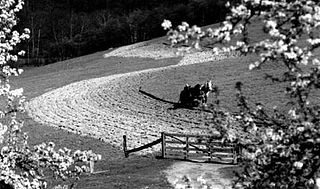
Contour plowing or contour farming is the farming practice of plowing and/or planting across a slope following its elevation contour lines. These contour line furrows create a water break which reduces the formation of rills and gullies during times of heavy precipitation, allowing more time for the water to settle into the soil. In contour plowing, the ruts made by the plow run perpendicular rather than parallel to the slopes, generally furrows that curve around the land and are level. This method is also known for preventing tillage erosion. Tillage erosion is the soil movement and erosion by tilling a given plot of land. A similar practice is contour bunding where stones are placed around the contours of slopes. Contour ploughing has been proved to reduce fertilizer loss, power and time consumption, and wear on machines, as well as to increase crop yields and reduces soil erosion.
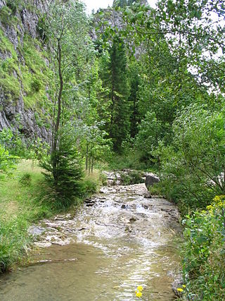
A ravine is a landform that is narrower than a canyon and is often the product of streambank erosion. Ravines are typically classified as larger in scale than gullies, although smaller than valleys. Ravines may also be called a cleuch, dell, ghout (Nevis), gill or ghyll, glen, gorge, kloof, and chine

Grey dunes are fixed, stable sand dunes that are covered by a continuous layer of herbaceous vegetation. These dunes are typically located 50–100 meters from the ocean shore and are found on the landward side of foredunes. Grey dunes are named for their characteristic grey color which is a result of the ground cover of lichen combined with a top soil layer of humus.
Drainage density is a quantity used to describe physical parameters of a drainage basin. First described by Robert E. Horton, drainage density is defined as the total length of channel in a drainage basin divided by the total area, represented by the following equation:

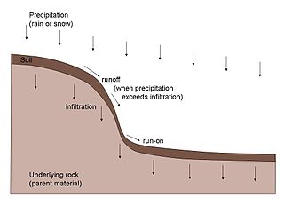
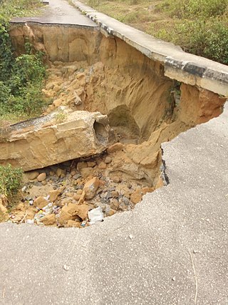
Surface runoff is the unconfined flow of water over the ground surface, in contrast to channel runoff. It occurs when excess rainwater, stormwater, meltwater, or other sources, can no longer sufficiently rapidly infiltrate in the soil. This can occur when the soil is saturated by water to its full capacity, and the rain arrives more quickly than the soil can absorb it. Surface runoff often occurs because impervious areas do not allow water to soak into the ground. Furthermore, runoff can occur either through natural or human-made processes.

Headward erosion is erosion at the origin of a stream channel, which causes the origin to move back away from the direction of the stream flow, lengthening the stream channel. It can also refer to the widening of a canyon by erosion along its very top edge, when sheets of water first enter the canyon from a more roughly planar surface above it, such as at Canyonlands National Park in Utah. When sheets of water on a roughly planar surface first enter a depression in it, this erodes the top edge of the depression. The stream is forced to grow longer at the very top of the stream, which moves its origin back, or causes the canyon formed by the stream to grow wider as the process repeats. Widening of the canyon by erosion inside the canyon, below the canyon side top edge, or origin or the stream, such as erosion caused by the streamflow inside it, is not called headward erosion.

Sheet erosion or sheet wash is the even erosion of substrate along a wide area. It occurs in a wide range of settings such as coastal plains, hill slopes, floodplains, beaches, savanna plains and semi-arid plains. Water moving fairly uniformly with a similar thickness over a surface is called sheet flow, and is the cause of sheet erosion. Sheet erosion implies that any flow of water that causes the erosion is not canalized. If a hillslope surface contains many irregularities, sheet erosion may give way to erosion along small channels called rills, which can then converge forming gullies. However, sheet erosion may occur despite some limited unevenness in the sheet flow arising from clods of earth, rock fragments, or vegetation.

A check dam is a small, sometimes temporary, dam constructed across a swale, drainage ditch, or waterway to counteract erosion by reducing water flow velocity. Check dams themselves are not a type of new technology; rather, they are an ancient technique dating from the second century AD. Check dams are typically, though not always, implemented in a system of several dams situated at regular intervals across the area of interest.

Asimov Crater is an impact crater in the Noachis quadrangle of Mars, located at 47.0° S and 355.05° W. It is 84.0 km (52.2 mi) in diameter and was named after Isaac Asimov (1920–1992), an American biochemist and writer. The name was officially adopted on May 4, 2009.
A rock veneer is a geomorphic formation in which rock fragments (clasts) of gravel or cobble size form a thin cover over a surface or hillslope. Rock veneers are typically one or two clasts thick and may partially or fully cover the ground surface. Veneers typically form in semiarid and arid regions where chemical weathering rates and the potential for mass wasting are low. Other names for a rock veneer are rock-fragment cover (RFC), stone pavement, desert pavement, stony mantle, hammada and reg.

The Cheltenham Badlands are in Caledon, Ontario, on the southeast side of Olde Base Line Road, between Creditview and Chinguacousy Roads. The site occupies an area of approximately 0.4 square kilometers and features exposed and highly eroded Queenston shale. The Cheltenham Badlands are a significant educational site due to the readily visible geologic processes and the red colour and the unique topography of the exposed shale make this a popular tourist site. The site is a Provincial Earth Sciences Area of Natural and Scientific Interest (ANSI) since it is considered one of the best examples of "badlands topography" in Ontario.
A catena in soil science (pedology) is a series of distinct but co-evolving soils arrayed down a slope. Each soil type or "facet" differs somewhat from its neighbours, but all occur in the same climate and on the same underlying parent material. A mature catena is in equilibrium as the processes of deposition and erosion are in balance.
Erodability is the inherent yielding or nonresistance of soils and rocks to erosion. A high erodibility implies that the same amount of work exerted by the erosion processes leads to a larger removal of material. Because the mechanics behind erosion depend upon the competence and coherence of the material, erodibility is treated in different ways depending on the type of surface that eroded.
The Nigerian gully erosion crisis has been underway since before 1980. It is an ecological, environmental, economic, and humanitarian disaster resulting in land degradation, as well as the loss of lives and properties worth millions of dollars. The estimated number of gullies in the country is at 3,000.

The May Sho’ate is a river of the Nile basin. Rising in the mountains of Dogu’a Tembien in northern Ethiopia, it flows southward to empty finally in Giba and Tekezé River.

Tillage erosion is a form of soil erosion occurring in cultivated fields due to the movement of soil by tillage. There is growing evidence that tillage erosion is a major soil erosion process in agricultural lands, surpassing water and wind erosion in many fields all around the world, especially on sloping and hilly lands A signature spatial pattern of soil erosion shown in many water erosion handbooks and pamphlets, the eroded hilltops, is actually caused by tillage erosion as water erosion mainly causes soil losses in the midslope and lowerslope segments of a slope, not the hilltops. Tillage erosion results in soil degradation, which can lead to significant reduction in crop yield and, therefore, economic losses for the farm.