Badlands

Last updated
The Chinle Badlands at Grand Staircase-Escalante National Monument in southern Utah Chinle Badlands.jpg
The Chinle Badlands at Grand Staircase–Escalante National Monument in southern Utah

Badlands are a type of dry terrain where softer sedimentary rocks and clay-rich soils have been extensively eroded. [1] They are characterized by steep slopes, minimal vegetation, lack of a substantial regolith, and high drainage density. [2] Ravines, gullies, buttes, hoodoos and other such geologic forms are common in badlands.

Contents

Badlands are found on every continent except Antarctica, being most common where there are unconsolidated sediments. They are often difficult to navigate by foot, and are unsuitable for agriculture. Most are a result of natural processes, but destruction of vegetation by overgrazing or pollution can produce anthropogenic badlands.

Badlands topography

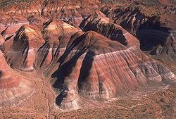
Badlands are characterized by a distinctive badlands topography. [3] [4] This is terrain in which water erosion has cut a very large number of deep drainage channels, separated by short, steep ridges ( interfluves ). [5] Such a drainage system is said to have a very fine drainage texture, [6] as measured by its drainage density . Drainage density is defined as the total length of drainage channels per unit area of land surface. Badlands have a very high drainage density of 48 to 464 kilometres per square kilometre (77 to 747 miles per square mile). [5] The numerous deep drainage channels and high interfluves creates a stark landscape of hills, gullies, and ravines. [3]

Caprock on hoodoos in Theodore Roosevelt National Park A030, Theodore Roosevelt National Park, North Dakota, USA, 2001.jpg
Caprock on hoodoos in Theodore Roosevelt National Park

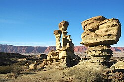
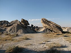
In addition to a dense system of drainages and interfluves, badlands often contain buttes and hoodoos. These are formed by resistant beds of sandstone, which form the caprock of the buttes and hoodoos. [4]

Origin

Badlands arise from a combination of an impermeable but easily eroded ground surface, sparse vegetation, and infrequent but heavy rainfall. [6] The surface bedrock is typically mudrock, sometimes with evaporites, with only occasional beds of more resistant sandstone. [5] Infrequent heavy rains lead to heavy erosional dissection. Where sudden precipitation cannot penetrate impermeable clays, it is channeled into a very dense system of streamlets that erode a dense system of ever-enlarging, coalescing gulleys and ravines. Erosion is enhanced by pelting raindrops that dislodge soft sediments. The presence of bentonite clay further increases erodability, as can rejuvenation of the drainage system from regional uplift, as occurred at Badlands National Park. [4]

In addition to surface erosion, badlands sometimes have well-developed piping, which is a system of pipes, joints, caverns, and other connected void spaces in the subsurface through which water can drain. However, this is not a universal feature of badlands. For example, the Henry Mountains badlands show very little piping. [2]

The precise processes by which the erosion responses take place vary depending on the precise interbedding of the sedimentary material. [7] However, it has been estimated that the badlands of Badlands National Park erode at the relatively high rate of about one inch or 25 millimetres per year. [8] The White River draining Badlands National Park was so named for its heavy load of bentonite clay eroded from the badlands. [4]

Regolith

Badlands are partially characterized by their thin to nonexistent regolith layers. The regolith profiles of badlands in arid climates are likely to resemble one another. In these regions, the upper layer (~1–5 cm or 0.4–2.0 in) is typically composed of silt, shale, and sand (a byproduct of the weathered shale). This layer can form either a compact crust or a looser, more irregular aggregation of "popcorn" fragments. Located beneath the top layer is a sublayer (~5–10 cm or 2.0–3.9 in), below which can be found a transitional shard layer (~10–40 cm or 3.9–15.7 in), formed largely of loose disaggregated shale chips, which in turn eventually gives way to a layer of unweathered shale. Badlands such as those found in the Mancos Shale, the Brule Formation, the Chadron Formation, and the Dinosaur Provincial Park can be generally said to fit this profile. [2]

In less arid regions, the regolith profile can vary considerably. Some badlands have no regolith layer whatsoever, capping instead in bare rock such as sandstone. Others have a regolith with a clay veneer, and still others have a biological crust of algae or lichens. [2]

In addition to lacking significant regolith, they also lack much vegetation. The lack of vegetation could very well be a result of the lack of a substantial regolith. [9]

Anthropogenic badlands

Cheltenham Badlands, Caledon, Ontario, Canada Cheltenham Badlands panorama1.jpg
Cheltenham Badlands, Caledon, Ontario, Canada

Although most badland topography is natural, badlands have been produced artificially by destruction of vegetation cover, through overgrazing, acid rain, or acid mine drainage. [5] The Cheltenham Badlands in Caledon, Ontario are an example of badlands produced by poor farming practices. In the early 1900s, the area was used for agricultural purposes, predominantly cattle grazing. Agricultural use ceased by 1931 and natural recovery of the majority of the property began. [10] Once established, however, this type of erosion can continue rapidly, if land clearing, over-grazing, and increased foot traffic by humans persists, as the shale is highly susceptible to erosion. [11]

An example of badlands created by mining is the Roman gold mine of Las Médulas in northern Spain.[ citation needed ]

Etymology

The word badlands is a calque from the Canadian French phrase les mauvaises terres, as the early French fur traders called the White River badlands les mauvaises terres à traverser or 'bad lands to traverse', perhaps influenced by the Lakota people who moved there in the late 1700s and who referred to the terrain as mako sica, meaning 'bad land' or 'eroded land'. [12]

The term malpaís means 'badlands' in Spanish, [13] but refers to a terrain of lava flows that is unlike the eroded badlands of the White River. [14]

Human impact

Badlands are generally unsuitable for agriculture, but attempts have been made to remediate badlands. For example, reforestation is being attempted in the Garhbeta, Eastern India, badlands [15] Revegetation and reforestation have been studied in the black marl badlands of the French Alps. Austrian black pine can become established and then be gradually replaced by native deciduous species. However, the time scale for this process is many decades. [16]

Locations

Valle de la Luna, San Juan, Argentina Ischigualasto provincial park.jpg
Valle de la Luna, San Juan, Argentina

Badlands are found on all the continents except Antarctica. The presence of unconsolidated sediments is a strong control on their locations. [17]

Argentina

The Valle de la Luna ("Valley of the Moon") is one of many examples of badland formations in midwestern Argentina. [18]

Canada

Badlands in Drumheller, Alberta Tyrrell Museum Badlands from the interpretive trail 8.jpg
Badlands in Drumheller, Alberta

The Cheltenham Badlands are in Caledon, Ontario, not far from the largest city Toronto. [19]

The Big Muddy Badlands in Saskatchewan [20] gained notoriety as a hideout for outlaws. [21]

There is a large badland area in Alberta, particularly in the valley of the Red Deer River, where Dinosaur Provincial Park is located, as well as in Drumheller, where the Royal Tyrrell Museum of Palaeontology is located. [22]

China

Badlands of the Zhangye National Geopark Linze, Zhangye, Gansu, China - panoramio (4).jpg
Badlands of the Zhangye National Geopark

Zhangye National Geopark is a badlands area known for its colorful rock formations. It has been voted by Chinese media outlets as one of the most beautiful landforms in China and became a UNESCO Global Geopark in 2019. [23]


India

Garhbeta, Eastern India is a badlands located in a monsoon climate. [15] Chambal [24] spread across northern parts of Madhya Pradesh, southeastern Rajasthan and southern parts of Uttar Pradesh known for its lawlessness and dacoity is another example of badlands. A small strip of badlands is also found in western Uttar Pradesh and Haryana.

Italy

The "Calanchi" of Aliano, in the Italian region of Basilicata Calanchi1.jpg
The "Calanchi" of Aliano, in the Italian region of Basilicata

In Italy, badlands are called "calanchi". Some examples are Aliano (Basilicata), Crete Senesi (Tuscany) and Civita di Bagnoregio (Lazio).

New Zealand

A well-known badlands formation in New Zealand – the Putangirua Pinnacles, formed by the erosion of the conglomerate of an old alluvial fan – is located at the head of a small valley near the southern tip of the North Island. [25] [26]

Spain

Badland landscape from the Bardenas Reales, in Navarre, Spain Bardenas Reales 10.jpg
Badland landscape from the Bárdenas Reales, in Navarre, Spain

The Bardenas Reales near Tudela, Navarre, the Tabernas Desert in Tabernas, Almería, parts of the Granada Altiplano near Guadix and possibly Los Monegros in Aragon are examples of Spanish badlands.

Turkey

Turkey has extensive badlands, [17] including Göreme National Park. [27]

United States

Toadstool Geologic Park in northwestern Nebraska Toadstool Geologic Park.jpg
Toadstool Geologic Park in northwestern Nebraska

In the U.S., Makoshika State Park in Montana and Badlands National Park in South Dakota are examples of extensive badland formations. Also located in this region is Theodore Roosevelt National Park, a United States National Park composed of three geographically separated areas of badlands in western North Dakota named after former U.S. President Theodore Roosevelt. Petrified Forest National Park in Arizona which is part of Navajo County encompasses numerous badlands that also abuts the Navajo Indian Reservation and is directly north of Joseph City, Arizona. Many dinosaurs are believed to be buried in the immediate area and exploration has been ongoing since the early 20th century. [28]

Among the Henry Mountains area in Utah, about 4,900 ft (1,500 m) above sea level, Cretaceous- and Jurassic-aged shales are exposed. [2] Another popular area of badland formations is Toadstool Geologic Park in the Oglala National Grassland located in northwestern Nebraska. Dinosaur National Monument in Colorado and Utah are also badlands settings, along with several other areas in southern Utah, such as the Chinle Badlands in Grand Staircase–Escalante National Monument. A small badland called Hell's Half-Acre is present in Natrona County, Wyoming. Additional badlands also exist in various places throughout southwest Wyoming, such as near Pinedale and in the Bridger Valley near the towns of Lyman and Mountain View, near the high Uintah Mountains. Pinnacles National Park in California also has areas of badlands, as does the Mojave Desert in eastern California.

Culture and media

Badlands have become a popular trope inside various different media, particularly westerns. [29]

See also

Related Research Articles

<span class="mw-page-title-main">Erosion</span> Natural processes that remove soil and rock

Erosion is the action of surface processes that removes soil, rock, or dissolved material from one location on the Earth's crust and then transports it to another location where it is deposited. Erosion is distinct from weathering which involves no movement. Removal of rock or soil as clastic sediment is referred to as physical or mechanical erosion; this contrasts with chemical erosion, where soil or rock material is removed from an area by dissolution. Eroded sediment or solutes may be transported just a few millimetres, or for thousands of kilometres.

<span class="mw-page-title-main">Painted Desert (Arizona)</span> Desert in Arizona

The Painted Desert is a United States desert of badlands in the Four Corners area, running from near the east end of Grand Canyon National Park and southeast into Petrified Forest National Park. It is most easily accessed from the north portion of Petrified Forest National Park. The Painted Desert is known for its brilliant and varied colors: these include the more common red rock, but also shades of lavender.

<span class="mw-page-title-main">Butte</span> Isolated hill with steep, often vertical sides and a small, relatively flat top

In geomorphology, a butte is an isolated hill with steep, often vertical sides and a small, relatively flat top; buttes are smaller landforms than mesas, plateaus, and tablelands. The word butte comes from the French word butte, meaning knoll ; its use is prevalent in the Western United States, including the southwest where mesa is used for the larger landform. Due to their distinctive shapes, buttes are frequently landmarks in plains and mountainous areas. To differentiate the two landforms, geographers use the rule of thumb that a mesa has a top that is wider than its height, while a butte has a top that is narrower than its height.

<span class="mw-page-title-main">Mesa</span> Elevated area of land with a flat top and sides

A mesa is an isolated, flat-topped elevation, ridge or hill, which is bounded from all sides by steep escarpments and stands distinctly above a surrounding plain. Mesas characteristically consist of flat-lying soft sedimentary rocks capped by a more resistant layer or layers of harder rock, e.g. shales overlain by sandstones. The resistant layer acts as a caprock that forms the flat summit of a mesa. The caprock can consist of either sedimentary rocks such as sandstone and limestone; dissected lava flows; or a deeply eroded duricrust. Unlike plateau, whose usage does not imply horizontal layers of bedrock, e.g. Tibetan Plateau, the term mesa applies exclusively to the landforms built of flat-lying strata. Instead, flat-topped plateaus are specifically known as tablelands.

<span class="mw-page-title-main">Florissant Formation</span> National monument in the United States

The Florissant Formation is a sedimentary geologic formation outcropping around Florissant, Teller County, Colorado. The formation is noted for the abundant and exceptionally preserved insect and plant fossils that are found in the mudstones and shales. Based on argon radiometric dating, the formation is Eocene in age and has been interpreted as a lake environment. The fossils have been preserved because of the interaction of the volcanic ash from the nearby Thirtynine Mile volcanic field with diatoms in the lake, causing a diatom bloom. As the diatoms fell to the bottom of the lake, any plants or animals that had recently died were preserved by the diatom falls. Fine layers of clays and muds interspersed with layers of ash form "paper shales" holding beautifully-preserved fossils. The Florissant Fossil Beds National Monument is a national monument established to preserve and study the geology and history of the area.

<span class="mw-page-title-main">Geology of the Zion and Kolob canyons area</span> Geology of Zion National Park in Utah

The geology of the Zion and Kolob canyons area includes nine known exposed formations, all visible in Zion National Park in the U.S. state of Utah. Together, these formations represent about 150 million years of mostly Mesozoic-aged sedimentation in that part of North America. Part of a super-sequence of rock units called the Grand Staircase, the formations exposed in the Zion and Kolob area were deposited in several different environments that range from the warm shallow seas of the Kaibab and Moenkopi formations, streams and lakes of the Chinle, Moenave, and Kayenta formations to the large deserts of the Navajo and Temple Cap formations and dry near shore environments of the Carmel Formation.

The exposed geology of the Bryce Canyon area in Utah shows a record of deposition that covers the last part of the Cretaceous Period and the first half of the Cenozoic era in that part of North America. The ancient depositional environment of the region around what is now Bryce Canyon National Park varied from the warm shallow sea in which the Dakota Sandstone and the Tropic Shale were deposited to the cool streams and lakes that contributed sediment to the colorful Claron Formation that dominates the park's amphitheaters.

<span class="mw-page-title-main">Colorado Plateau</span> Plateau in southwestern United States

The Colorado Plateau, also known as the Colorado Plateau Province, is a physiographic and desert region of the Intermontane Plateaus, roughly centered on the Four Corners region of the southwestern United States. This province covers an area of 336,700 km2 (130,000 mi2) within western Colorado, northwestern New Mexico, southern and eastern Utah, northern Arizona, and a tiny fraction in the extreme southeast of Nevada. About 90% of the area is drained by the Colorado River and its main tributaries: the Green, San Juan, and Little Colorado. Most of the remainder of the plateau is drained by the Rio Grande and its tributaries.

<span class="mw-page-title-main">Hoodoo (geology)</span> Tall, thin spire of relatively soft rock usually topped by harder rock

A hoodoo is a tall, thin spire of rock formed by erosion. Hoodoos typically consist of relatively soft rock topped by harder, less easily eroded stone that protects each column from the elements. They generally form within sedimentary rock and volcanic rock formations.

<span class="mw-page-title-main">Goblin Valley State Park</span> State park in Utah, United States

Goblin Valley State Park is a state park of Utah, in the United States. The park features thousands of hoodoos, referred to locally as goblins, which are formations of mushroom-shaped rock pinnacles, some as tall as several yards (meters). The distinct shapes of these rocks result from an erosion-resistant layer of rock atop relatively softer sandstone. Goblin Valley State Park and Bryce Canyon National Park, also in Utah about 190 miles (310 km) to the southwest, contain some of the largest occurrences of hoodoos in the world.

<span class="mw-page-title-main">Geology of the Capitol Reef area</span>

The exposed geology of the Capitol Reef area presents a record of mostly Mesozoic-aged sedimentation in an area of North America in and around Capitol Reef National Park, on the Colorado Plateau in southeastern Utah.

<span class="mw-page-title-main">Rill</span> Shallow channel cut by water

In hillslope geomorphology, a rill is a shallow channel cut into soil by the erosive action of flowing surface water. Similar but smaller incised channels are known as microrills; larger incised channels are known as gullies.

<span class="mw-page-title-main">Hogback (geology)</span> Long, narrow ridge

In geology and geomorphology, a hogback or hog's back is a long, narrow ridge or a series of hills with a narrow crest and steep slopes of nearly equal inclination on both flanks. Typically, the term is restricted to a ridge created by the differential erosion of outcropping, steeply dipping, homoclinal, and typically sedimentary strata. One side of a hogback consists of the surface of a steeply dipping rock stratum called a dip slope. The other side is an erosion face that cuts through the dipping strata that comprises the hogback. The name "hogback" comes from the Hog's Back of the North Downs in Surrey, England, which refers to the landform's resemblance in outline to the back of a hog. The term is also sometimes applied to drumlins and, in Maine, to both eskers and ridges known as "horsebacks".

<span class="mw-page-title-main">Bisti/De-Na-Zin Wilderness</span> Wilderness in New Mexico, United States

The Bisti/De-Na-Zin Wilderness is a 45,000-acre (18,000 ha) wilderness area located in San Juan County in the U.S. state of New Mexico. Established in 1984, the Wilderness is a desolate area of steeply eroded badlands managed by the Bureau of Land Management, except three parcels of private Navajo land within its boundaries. The John D. Dingell, Jr. Conservation, Management, and Recreation Act, signed March 12, 2019, expanded the Bisti/De-Na-Zin Wilderness by approximately 2,250 acres.

<span class="mw-page-title-main">Malpaís (landform)</span> Rough and barren landscape of relict and largely uneroded lava fields

Malpaís, in the Southwestern United States, Spain, Mexico, and other Spanish-speaking regions, are rough and barren landscapes that consist of relict and largely uneroded lava fields exhibiting recognizable lava flows, volcanic cones, and other volcanic landforms. This type of volcanic landscape is extremely rough and difficult to traverse. It is characteristic of arid environments because in more humid climates, such rough terrains are smoothed by erosion and vegetation.

<span class="mw-page-title-main">Danxia landform</span> Various landscapes found in China

The Danxia landform refers to various landscapes found in southeast, southwest and northwest China that "consist of a red bed characterized by steep cliffs". It is a unique type of petrographic geomorphology found in China. Danxia landform is formed from red-coloured sandstones and conglomerates of largely Cretaceous age. The landforms look very much like karst topography that forms in areas underlain by limestones, but since the rocks that form danxia are sandstones and conglomerates, they have been called "pseudo-karst" landforms. They were formed by endogenous forces and exogenous forces.

<span class="mw-page-title-main">Cheltenham Badlands</span> Badlands in Caledon, Ontario, Canada

The Cheltenham Badlands are in Caledon, Ontario, on the southeast side of Olde Base Line Road, between Creditview and Chinguacousy Roads. The site occupies an area of approximately 0.4 square kilometers and features exposed and highly eroded Queenston shale. The Cheltenham Badlands are a significant educational site due to the readily visible geologic processes and the red colour and the unique topography of the exposed shale make this a popular tourist site. The site is a Provincial Earth Sciences Area of Natural and Scientific Interest (ANSI) since it is considered one of the best examples of "badlands topography" in Ontario.

<span class="mw-page-title-main">Scarp retreat</span>

Scarp retreat is a geological process through which the location of an escarpment changes over time. Typically the cliff is undermined, rocks fall and form a talus slope, the talus is chemically or mechanically weathered and then removed through water or wind erosion, and the process of undermining resumes. Scarps may retreat for tens of kilometers in this way over relatively short geological time spans, even in arid locations.

A fin is a geological formation that is a narrow, residual wall of hard sedimentary rock that remains standing after surrounding rock has been eroded away along parallel joints or fractures. Fins are formed when a narrow butte or plateau develops many vertical, parallel cracks. There are two main modes of following erosion. The first is when water flows along joints and fractures and opens them wider and wider, eventually causing erosion. The second is where the rock type (stratum) is harder and more erosion resistant than neighboring rocks, causing the weaker rock to fall away.

<span class="mw-page-title-main">Geology of South Dakota</span>

The geology of South Dakota began to form more than 2.5 billion years ago in the Archean eon of the Precambrian. Igneous crystalline basement rock continued to emplace through the Proterozoic, interspersed with sediments and volcanic materials. Large limestone and shale deposits formed during the Paleozoic, during prevalent shallow marine conditions, followed by red beds during terrestrial conditions in the Triassic. The Western Interior Seaway flooded the region, creating vast shale, chalk and coal beds in the Cretaceous as the Laramide orogeny began to form the Rocky Mountains. The Black Hills were uplifted in the early Cenozoic, followed by long-running periods of erosion, sediment deposition and volcanic ash fall, forming the Badlands and storing marine and mammal fossils. Much of the state's landscape was reworked during several phases of glaciation in the Pleistocene. South Dakota has extensive mineral resources in the Black Hills and some oil and gas extraction in the Williston Basin. The Homestake Mine, active until 2002, was a major gold mine that reached up to 8000 feet underground and is now used for dark matter and neutrino research.

References

  1. "Badlands" in Chambers's Encyclopædia . London: George Newnes, 1961, Vol. 2, p. 47.
  2. 1 2 3 4 5 A.J. Parsons and A.D. Abrahams, Editors (2009) Geomorphology of Desert Environments (2nd ed.) Springer Science & Business Media ISBN   978-1402057182
  3. 1 2 Lillie, Robert J. (2005). Parks and plates : the geology of our national parks, monuments, and seashores (1st ed.). New York: W.W. Norton. p. 267. ISBN   0393924076.
  4. 1 2 3 4 Levin, Harold L. (2010). The earth through time (9th ed.). Hoboken, N.J.: J. Wiley. p. 475. ISBN   978-0470387740.
  5. 1 2 3 4 Jackson, Julia A., ed. (1997). "badlands". Glossary of geology (Fourth ed.). Alexandria, Virginia: American Geological Institute. ISBN   0922152349.
  6. 1 2 Thornbury, William D. (1969). Principles of geomorphology (2d ed.). New York: Wiley. p. 127. ISBN   0471861979.
  7. Thomas, D., ed. (2011). Arid zone geomorphology : process, form and change in drylands (3rd ed.). Chichester, West Sussex: Wiley-Blackwell. ISBN   978-0470519097.
  8. "Geologic Formations: How Badlands Buttes Came to Be". National Park Service. 10 November 2020.
  9. Bryan, R. and A. Yair, 1982a. Perspectives on studies of badland geomorphology. In Badland geomorphology and piping. R. Bryan and A. Yair (eds), 1-3. Norwich: Geo Books.
  10. "Cheltenham Badlands Management Planning Background Information" (PDF). Bruce Trail Conservancy. 2012. p. 4-5. Archived from the original (PDF) on 2021-05-21. Retrieved 2024-03-08.
  11. Guillet, J.R (1977). Clay and Shale Deposits of Ontario, Ontario Geological Survey, Mineral Deposits Circular MDC15 (PDF).
  12. Shaw, Ethan (2018-03-18). "How Did Badlands National Park Get Its Name?". USA Today . Retrieved 2019-08-01.
  13. "Frequently asked questions". El Malpais National Monument. National Park Service. Retrieved 18 January 2021.
  14. Jackson, Julia A., ed. (1997). "Malpais". Glossary of geology (Fourth ed.). Alexandria, Virginia: American Geological Institute. ISBN   0922152349.
  15. 1 2 Saha, Asish; Pal, Subodh Chandra; Arabameri, Alireza; Chowdhuri, Indrajit; Rezaie, Fatemeh; Chakrabortty, Rabin; Roy, Paramita; Shit, Manisa (June 2021). "Optimization modelling to establish false measures implemented with ex-situ plant species to control gully erosion in a monsoon-dominated region with novel in-situ measurements". Journal of Environmental Management. 287: 112284. doi:10.1016/j.jenvman.2021.112284. PMID   33711662. S2CID   232217656.
  16. Gallart, Francesc; Marignani, Michela; Pérez-Gallego, Nuria; Santi, Elisa; Maccherini, Simona (July 2013). "Thirty years of studies on badlands, from physical to vegetational approaches. A succinct review". CATENA. 106: 4–11. Bibcode:2013Caten.106....4G. doi:10.1016/j.catena.2012.02.008.
  17. 1 2 Avcioglu, Aydogan; Gorum, Tolga; Akbas, Abdullah; Moreno de las Heras, Mariano; Yetemen, Omer (2021). "The climatic, topographic and litho-tectonic characteristics of badlands in Turkey". EGU General Assembly Conference Abstracts. Bibcode:2021EGUGA..23.7788A. doi: 10.5194/egusphere-egu21-7788 . S2CID   236762970.
  18. "Ischigualasto / Talampaya Natural Parks". UNESCO World Heritage Centre.
  19. Kasanin-Grubin, Milica (2013-07-01). "Clay mineralogy as a crucial factor in badland hillslope processes". CATENA. Updating Badlands Research. 106: 54–67. Bibcode:2013Caten.106...54K. doi:10.1016/j.catena.2012.08.008. ISSN   0341-8162.
  20. Harel, Claude-Jean (2006). "Big Muddy Valley". Encyclopedia of Saskatchewan. Great Plains Research Center. Archived from the original on 2009-06-19. Retrieved 2010-05-11.
  21. Yanko, Dave. "Outlaw Rule". Virtual Saskatchewan. Retrieved 2010-05-11.
  22. Currie, P.J.; Koppelhus, E.B., eds. (2005). Dinosaur Provincial Park : a spectacular ancient ecosystem revealed. Bloomington: Indiana University Press. ISBN   9780253345950.
  23. "ZHANGYE UNESCO GLOBAL GEOPARK".
  24. "28/07/2020". Empower IAS. Retrieved 2022-09-05.
  25. "Putangirua Pinnacles Scenic Reserve". www.doc.govt.nz.
  26. Lloyd Homer and Phil Moore, "Reading the Rocks: Aguide to the Geological Features of the Wairarapa Coast", Landscape Publications limited, 1989
  27. Ertek, T. Ahmet (12 March 2021). "The Geoheritage of Göreme National Park and the Rock Sites of Cappadocia, Turkey". Zeitschrift für Geomorphologie, Supplementary Issues. 62 (3): 333–348. Bibcode:2021ZGmS...62..333E. doi:10.1127/zfg_suppl/2021/0702. S2CID   233709481.
  28. Ash, Sidney (2005). Petrified Forest: A Story in Stone (2nd rev. ed.). Petrified Forest National Park, Arizona: Petrified Forest Museum Association. ISBN   978-0-945695-11-0.
  29. Río, David (2016). "Facing Old Age and Searching for Regeneration in a Dying American West: Gregory Martin's "Mountain City" / Afrontando la vejez y buscando la regeneración en un Oeste norteamericano moribundo: "Mountain City", de Gregory Martin" (PDF). Atlantis. 38 (1): 149–164. JSTOR   24757762.