
An interfluve is a narrow, elongated and plateau-like or ridge-like landform between two valleys. [1] [2] More generally, an interfluve is defined as an area of higher ground between two rivers in the same drainage system. [3]
An interfluve is a narrow, elongated and plateau-like or ridge-like landform between two valleys. [1] [2] More generally, an interfluve is defined as an area of higher ground between two rivers in the same drainage system. [3]
These landforms are created by earth flow ("solifluction"). They can also be former river terraces that are subsequently bisected by fluvial erosion. In cases where there is a deposit of younger sedimentary beds (loess, colluvium) the interfluves have a rounder and less rugged appearance. A consequence of interfluve formation is the so-called "interfluvial landscape." [2]

The Black Forest is a large forested mountain range in the state of Baden-Württemberg in southwest Germany, bounded by the Rhine Valley to the west and south and close to the borders with France and Switzerland. It is the source of the Danube and Neckar rivers.

Karst is a topography formed from the dissolution of soluble carbonate rocks such as limestone, dolomite, and gypsum. It is characterized by features like poljes above and drainage systems with sinkholes and caves underground. It has also been documented for more weathering-resistant rocks, such as quartzite, given the right conditions.

The Eifel is a low mountain range in western Germany, eastern Belgium and northern Luxembourg. It occupies parts of southwestern North Rhine-Westphalia, northwestern Rhineland-Palatinate and the southern area of the German-speaking Community of Belgium.
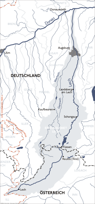
The Lech is a river in Austria and Germany. It is a right tributary of the Danube 255 kilometres (158 mi) in length with a drainage basin of 3,919 square kilometres (1,513 sq mi). Its average discharge at the mouth is 115 m3/s (4,100 cu ft/s). Its source is located in the Austrian state of Vorarlberg, where the river rises from lake Formarinsee in the Alps at an altitude of 1,870 metres (6,120 ft). It flows in a north-north-easterly direction and crosses the German border, forming the Lechfall, a 12-metre-high (39 ft) waterfall; afterwards the river enters a narrow gorge. Leaving the Alps, it enters the plains of the Allgäu at Füssen at an elevation of 790 metres (2,580 ft) in the German state of Bavaria, where it used to be the location of the boundary with Swabia. The river runs through the city of Füssen and through the Forggensee, a man-made lake which is drained in winter. Here, it forms rapids and a waterfall.
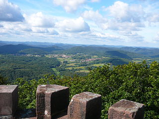
Landforms are categorized by characteristic physical attributes such as their creating process, shape, elevation, slope, orientation, rock exposure, and soil type.

The Cumberland Plateau is the southern part of the Appalachian Plateau in the Appalachian Mountains of the United States. It includes much of eastern Kentucky and Tennessee, and portions of northern Alabama and northwest Georgia. The terms "Allegheny Plateau" and the "Cumberland Plateau" both refer to the dissected plateau lands lying west of the main Appalachian Mountains. The terms stem from historical usage rather than geological difference, so there is no strict dividing line between the two. Two major rivers share the names of the plateaus, with the Allegheny River rising in the Allegheny Plateau and the Cumberland River rising in the Cumberland Plateau in Harlan County, Kentucky.
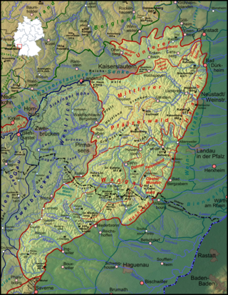
The Palatinate Forest, sometimes also called the Palatine Forest, is a low-mountain region in southwestern Germany, located in the Palatinate in the state of Rhineland-Palatinate. The forest is a designated nature park covering 1,771 km2 and its highest elevation is the Kalmit.

Upper Swabia is a region in Germany in the federal states of Baden-Württemberg and Bavaria. The name refers to the area between the Swabian Jura, Lake Constance and the Lech. Its counterpart is Lower Swabia (Niederschwaben), the region around Heilbronn.

Krumbach is a town with 13,000 residents in the district Günzburg in Swabia, Bavaria, Germany. It is the second biggest town in the district.

The Allgäu Alps are a mountain range in the Northern Limestone Alps, located in Bavaria and Baden-Württemberg in Germany and Tyrol and Vorarlberg in Austria. The range lies directly east of Lake Constance.
Niederraunau is a quarter of the town Krumbach in Günzburg (district), Swabia, Bavaria, Germany.

This division of Germany into major natural regions takes account primarily of geomorphological, geological, hydrological, and pedological criteria in order to divide the country into large, physical units with a common geographical basis. Political boundaries play no part in this, apart from defining the national border.
The Alpine Foreland, less commonly called the Bavarian Foreland, Bavarian Plateau or Bavarian Alpine Foreland, refers to a triangular region of plateau and rolling foothills in Southern Germany, stretching from Lake Constance in the west to beyond Linz on the Danube in the east, with the Bavarian Alps forming its south boundary and the Danube its northern extent.

The Iller-Lech Plateau, also known as the Upper Swabian Plateau, is one of the natural regions of Germany.
The Wasgau is a Franco-German hill range in the German state of Rhineland-Palatinate and the French departments of Bas-Rhin and Moselle. It is formed from the southern part of the Palatine Forest and the northern part of the Vosges mountains, and extends from the River Queich in the north over the French border to the Col de Saverne in the south.

The Westrich Plateau, also Zweibrücken Westrich or Southwest Palatine Plateau, is a landscape in the German state of Rhineland-Palatinate, with small areas also in the Saarland (Saarpfalz-Kreis). Its heart is in the southwest of the Palatinate region and it is part of the historic region of Westrich.

The Hohloh is a mountain, 988.3 m above sea level (NHN), on the eastern main ridge of the Northern Black Forest in Germany. It lies near the village of Kaltenbronn in the borough of Gernsbach, a town in the county of Rastatt in the German state of Baden-Württemberg. Its summit is the highest point in the borough of Gernsbach and the eastern chain of the Northern Black Forest, the ridge between the rivers Murg and Enz. A mountain pass runs northeast of the summit plateau between the two river valleys passing over the saddle of Schwarzmiss.

The Wutach Gorge is a narrow, steep-sided valley in southern Germany through in the upper reaches of the River Wutach with three gorge-like sections, the lowest of which is also called the Wutachflühen. The gorge cuts through the southern part of the Baar region from the eastern side of the High Black Forest heading eastwards to the Trauf the steep, northwestern flank of the Swabian Jura, which transitions to the Randen mountains here.
Biber or the Biber Complex is a timespan approximately 2.6–1.8 million years ago in the glacial history of the Alps. Biber corresponds to the Gelasian age in the international geochronology, which since 2009 is regarded as the first age of the Quaternary period. Deep sea core samples have identified approximately 20 glacial cycles of varying intensity during Biber.

The Holzstöcke is an elongated, densely forested, mountain range running from north to south in the German state of Baden-Württemberg. It is up to about 700 m above sea level (NN) and covers and area of 381.9 square kilometres. It is a large, terraced landscape that is part of the Iller-Lech Plateau in the Alpine Foreland of south Germany. It lies southwest of the city of Ulm in the counties of Alb-Donau-Kreis and Biberach in Upper Swabia and rises above the valley floors by about 75 metres.