A valley is an elongated low area often running between hills or mountains and typically containing a river or stream running from one end to the other. Most valleys are formed by erosion of the land surface by rivers or streams over a very long period. Some valleys are formed through erosion by glacial ice. These glaciers may remain present in valleys in high mountains or polar areas.
At lower latitudes and altitudes, glacially formed valleys may have been created or enlarged during ice ages but now are ice-free and occupied by streams or rivers. In desert areas, valleys may be entirely dry or carry a watercourse only rarely. In areas of limestone bedrock, dry valleys may result from drainage now taking place underground rather than at the surface. Rift valleys arise principally from earth movements, rather than erosion. Many different types of valleys are described by geographers, using terms that may be global in use or else applied only locally.
Formation of valleys
Valleys are depressions in the morphology that slope in one direction along their entire length. They tend to be longer than wide and come in a variety of dimensions.[1] Valleys may arise through several different processes. Most commonly, they are created from erosion over long periods by moving water and are known as river valleys. The processes that alter the river valley surface include corrasion, abrasion, pot-holing, corrosion, and weathering.[1]
Typically, small valleys containing streams feed into larger valleys which in turn feed into larger valleys again,[2] eventually reaching the ocean or perhaps an internal drainage basin. In polar areas and at high altitudes, valleys may be eroded by glaciers; these typically have a U-shaped profile in cross-section,[3] in contrast to river valleys, which tend to have a V-shaped profile. Other valleys may arise principally through tectonic processes such as rifting. All three processes can contribute to the development of a valley over geological time. The flat (or relatively flat) portion of a valley between its sides is referred to as the valley floor. The valley floor is typically formed by river sediments and may be flanked by fluvial terraces.[4]
River valleys
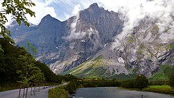
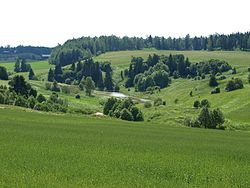
The valley of Halikko River in Halikko, FinlandValley of Palakaria River springing from Vitosha Mountain, seen in the background, in Bulgaria
The development of a river valley is affected by the character of the bedrock or alluvium over which the river or stream flows, the elevational difference between its top and bottom, and the climate. Typically the flow will increase downstream and the gradient will decrease. In the upper valley, the stream will most effectively erode its bed through corrasion to produce a steep-sided V-shaped valley. The presence of more resistant rock bands, of geological faults, fractures, and folds may determine the course of the stream and result in a twisting course with interlocking spurs.
In the middle valley, as numerous streams have coalesced, the valley is typically wider, the flow slower and both erosion and deposition may take place. More lateral erosion takes place in the middle section of a river's course, as strong currents on the outside of its curve erode the bank. Conversely, deposition may take place on the inside of curves where the current is much slacker, the process leading to the river assuming a meandering character. In the lower valley, gradients are lowest, meanders may be much broader and a broader floodplain may result. Deposition dominates over erosion.[5][6] A typical river basin or drainage basin will incorporate each of these different types of valleys.
Some sections of a stream or river valleys may have vertically incised their course to such an extent that the valley they occupy is best described as a gorge, ravine, or canyon. Rapid down-cutting may result from localized uplift of the land surface or rejuvenation of the watercourse as a result for example of a reduction in the base level to which the river is eroded, e.g. lowered global sea level during an ice age. Such rejuvenation may also result in the production of river terraces.[7]
A glaciated valley in the Mount Hood Wilderness showing a characteristic U-shape, the bottom's rocky 'rubble' accretion and the broad shoulders
There are various forms of valleys associated with glaciation. True glacial valleys are those that have been cut by a glacier which may or may not still occupy the valley at the present day. Such valleys may also be known as glacial troughs. They typically have a U-shaped cross-section and are characteristic landforms of mountain areas where glaciation has occurred or continues to take place.[8] This parabola shape is caused by glacial erosion removing the contact surfaces with greatest resistance to flow, and the resulting section minimises friction.[9][10]
The uppermost part of a glacial valley frequently consists of one or more 'armchair-shaped' hollows, or 'cirques', excavated by the rotational movement downslope of a cirque glacier. During glacial periods, for example, the Pleistocene ice ages, it is in these locations that glaciers initially form and then, as the ice age proceeds, extend downhill through valleys that have previously been shaped by water rather than ice. Abrasion by rock material embedded within the moving glacial ice causes the widening and deepening of the valley to produce the characteristic U or trough shape with relatively steep, even vertical sides and a relatively flat bottom.
Interlocking spurs associated with the development of river valleys are preferentially eroded to produce truncated spurs, typical of glaciated mountain landscapes. The upper end of the trough below the ice-contributing cirques may be a trough-end. Valley steps (or 'rock steps') can result from differing erosion rates due to both the nature of the bedrock (hardness and jointing for example) and the power of the moving ice. In places, a rock basin may be excavated which may later be filled with water to form a ribbon lake or else by sediments. Such features are found in coastal areas as fjords. The shape of the valley which results from all of these influences may only become visible upon the recession of the glacier that forms it.[11] A river or stream may remain in the valley; if it is smaller than one would expect given the size of its valley, it can be considered an example of a misfit stream.
A panoramic view of two merging U-shaped valleys in Pirin mountain, Bulgaria
Other interesting glacially carved valleys include:
A tunnel valley is a large, long, U-shaped valley originally cut under the glacial ice near the margin of continental ice sheets such as that now covering Antarctica and formerly covering portions of all continents during past glacial ages.[12] Such valleys can be up to 100km (62mi) long, 4km (2.5mi) wide, and 400m (1,300ft) deep (its depth may vary along its length). Tunnel valleys were formed by subglacial water erosion. They once served as subglacial drainage pathways carrying large volumes of meltwater. Their cross-sections exhibit steep-sided flanks similar to fjord walls, and their flat bottoms are typical of subglacial glacial erosion.
In northern Central Europe, the Scandinavian ice sheet during the various ice ages advanced slightly uphill against the lie of the land. As a result, its meltwaters flowed parallel to the ice margin to reach the North Sea basin, forming huge, flat valleys known as Urstromtäler. Unlike the other forms of glacial valleys, these were formed by glacial meltwaters.
Look from Paria View to a valley in Bryce Canyon, Utah, with very striking shoulders
Depending on the topography, the rock types, and the climate, a variety of transitional forms between V-, U- and plain[clarification needed] valleys can form. The floor or bottom of these valleys can be broad or narrow, but all valleys have a shoulder. The broader a mountain valley, the lower its shoulders are located in most cases. An important exception is canyons where the shoulder almost is near the top of the valley's slope. In the Alps – e.g. the TyroleanInn valley – the shoulders are quite low (100–200 meters above the bottom). Many villages are located here (esp. on the sunny side) because the climate is very mild: even in winter when the valley's floor is filled with fog, these villages are in sunshine.
In some stress-tectonic regions of the Rocky Mountains or the Alps (e.g. Salzburg), the side valleys are parallel to each other, and are hanging. Smaller streams flow into rivers as deep canyons or waterfalls.
A hanging valley is a tributary valley that is higher than the main valley. They are most commonly associated with U-shaped valleys, where a tributary glacier flows into a glacier of larger volume. The main glacier erodes a deep U-shaped valley with nearly vertical sides, while the tributary glacier, with a smaller volume of ice, makes a shallower U-shaped valley. Since the surfaces of the glaciers were originally at the same elevation, the shallower valley appears to be 'hanging' above the main valley. Often, waterfalls form at or near the outlet of the upper valley.[13]
Hanging valleys also occur in fjord systems underwater. The branches of Sognefjord are much shallower than the main fjord. The mouth of Fjærlandsfjord is about 400 meters (1,300ft) deep while the main fjord nearby is 1,200 meters (3,900ft) deep. The mouth of Ikjefjord is only 50 meters (160ft) deep while the main fjord is around 1,300 meters (4,300ft) at the same point.[14]
Glaciated terrain is not the only site of hanging streams and valleys. Hanging valleys are also simply the product of varying rates of erosion of the main valley and the tributary valleys. The varying rates of erosion are associated with the composition of the adjacent rocks in the different valley locations. The tributary valleys are eroded and deepened by glaciers or erosion at a slower rate than that of the main valley floor; thus the difference in the two valleys' depth increases over time. The tributary valley, composed of more resistant rock, then hangs over the main valley.[15]
Trough-shaped
Trough-shaped valleys also form in regions of heavy topographic denudation. By contrast with glacial U-shaped valleys, there is less downward and sideways erosion. The severe downslope denudation results in gently sloping valley sides; their transition to the actual valley bottom is unclear. Trough-shaped valleys occur mainly in periglacial regions and in tropical regions of variable wetness. Both climates are dominated by heavy denudation.[16]
Box
Box valleys have wide, relatively level floors and steep sides. They are common in periglacial areas and occur in mid-latitudes, but also occur in tropical and arid regions.[17]
Rift valleys, such as the Albertine Rift and Gregory Rift are formed by the expansion of the Earth's crust due to tectonic activity beneath the Earth's surface.
Terms for valleys
There are many terms used for different sorts of valleys. They include:
Arroyo: a dry watercourse that temporarily or seasonally fills and flows after sufficient rain.
Cove: A small valley, closed at one or both ends, in the central or southern Appalachian Mountains which sometimes results from the erosion of a geologic window.
Canyon or gorge:[1] a deep cleft between escarpments or cliffs resulting from weathering and the erosive activity of a river.
The terms corrie, glen, and strath are all Anglicisations of Gaelic terms and are commonly encountered in place-names in Scotland and other areas where Gaelic was once widespread. Strath signifies a wide valley between hills, the floor of which is either level or slopes gently.[19] A glen is a river valley which is steeper and narrower than a strath.[20] A corrie is a basin-shaped hollow in a mountain.[21] Each of these terms also occurs in parts of the world formerly colonized by Britain. Corrie is used more widely by geographers as a synonym for (glacial) cirque, as is the word cwm borrowed from Welsh.[22]
The word dale occurs widely in place names in the north of England and, to a lesser extent, in southern Scotland. As a generic name for a type of valley, the term typically refers to a wide valley, though there are many much smaller stream valleys within the Yorkshire Dales which are named "(specific name) Dale".[23]Clough is a word in common use in northern England for a narrow valley with steep sides.[24]Gill is used to describe a ravine containing a mountain stream in Cumbria and the Pennines.[25] The term combe (also encountered as coombe) is widespread in southern England and describes a short valley set into a hillside.[26] Other terms for small valleys such as hope, dean, slade, slack and bottom are commonly encountered in place-names in various parts of England but are no longer in general use as synonyms for valley.
The term vale is used in England and Wales to describe a wide river valley, usually with a particularly wide flood plain or flat valley bottom. In Southern England, vales commonly occur between the outcrops of different relatively erosion-resistant rock formations, where less resistant rock, often claystone has been eroded. An example is the Vale of White Horse in Oxfordshire.
Human settlement
Some of the first human complex societies originated in river valleys, such as that of the Nile, Tigris-Euphrates, Indus, Ganges, Yangtze, Yellow River, Mississippi, and arguably the Amazon. In prehistory, the rivers were used as a source of fresh water and food (fish and game), as well as a place to wash and a sewer. The proximity of water moderated temperature extremes and provided a source for irrigation, stimulating the development of agriculture. Most of the first civilizations developed from these river valley communities. Siting of settlements within valleys is influenced by many factors, including the need to avoid flooding and the location of river crossing points.
Numerous elongate depressions have been identified on the surface of Mars, Venus, the Moon, and other planets and their satellites and are known as valles (singular: 'vallis'). Deeper valleys with steeper sides (akin to canyons) on certain of these bodies are known as chasmata (singular: 'chasma'). Long narrow depressions are referred to as fossae (singular: 'fossa').[27] These are the Latin terms for 'valley, 'gorge' and 'ditch' respectively. The German term 'rille' or Latin term 'rima' (signifying 'cleft') is used for certain other elongate depressions on the Moon.[28]
↑Schumm, Stanley A.; Ethridge, Frank G. "Origin, Evolution and Morphology of Fluvial Valleys". In Dalrymple, Robert W.; Boyd, Ron; Zaitlin, Brian A. (eds.). Incised-Valley Systems: Origin and Sedimentary Sequences. Vol.51. SEPM Society for Sedimentary Geology. doi:10.2110/pec.94.12.0011.
↑Hirano, Masasgige; Aniya, Masamu (December 1988). "A rational explanation of cross-profile morphology for glacial valleys and of glacial valley development". Earth Surface Processes and Landforms. Wiley Online Library. 13 (8): 707–716. doi:10.1002/esp.3290130805.
↑Graf, William L. (Autumn 1970). "The Geomorphology of the Glacial Valley Cross Section". Arctic and Alpine Research. 2 (4). Taylor & Francis, Ltd.: 303–312. doi:10.2307/1550243. JSTOR1550243.
↑Monkhouse, F.J. (1971). Principles of Physical Geography (Seventhed.). London: University of London Press Ltd. pp.230–234. ISBN0340090227.
↑Jørgensen, Flemming; Sandersen, Peter B. E. (June 2006). "Buried and open tunnel valleys in Denmark—erosion beneath multiple ice sheets". Quaternary Science Reviews. 25 (11–12): 1339–1363. Bibcode:2006QSRv...25.1339J. doi:10.1016/j.quascirev.2005.11.006.
↑"Early History, Santa Clara County". National Park Service. Archived from the original on July 3, 2007. Retrieved January 16, 2015. Santa Clara Valley is a structural valley, created by mountain building, as opposed to an erosional valley, or one which has undergone the wearing away of the earth's surface by natural agents.
↑Ross, David (2001). Scottish Place-names (Firsted.). Edinburgh: Birlinn. p.203. ISBN1841581739.
↑Ross, David (2001). Scottish Place-names (Firsted.). Edinburgh: Birlinn. p.99. ISBN1841581739.
↑Ross, David (2001). Scottish Place-names (Firsted.). Edinburgh: Birlinn. p.53. ISBN1841581739.
↑"Bing maps". Microsoft Bing. Retrieved 20 December 2020.
↑Gelling, Margaret (1984). Place-names in the Landscape: the Geographical roots of Britain's place-names (Firsted.). London: J M Dent. p.88. ISBN0460860860.
↑Gelling, Margaret (1984). Place-names in the Landscape: the Geographical roots of Britain's place-names (Firsted.). London: J M Dent. p.99. ISBN0460860860.
This page is based on this Wikipedia article Text is available under the CC BY-SA 4.0 license; additional terms may apply. Images, videos and audio are available under their respective licenses.