
Erosion is the action of surface processes that removes soil, rock, or dissolved material from one location on the Earth's crust and then transports it to another location where it is deposited. Erosion is distinct from weathering which involves no movement. Removal of rock or soil as clastic sediment is referred to as physical or mechanical erosion; this contrasts with chemical erosion, where soil or rock material is removed from an area by dissolution. Eroded sediment or solutes may be transported just a few millimetres, or for thousands of kilometres.

Karst is a topography formed from the dissolution of soluble carbonate rocks such as limestone and dolomite. It is characterized by features like poljes above and drainage systems with sinkholes and caves underground. There is some evidence that karst may occur in more weathering-resistant rocks such as quartzite given the right conditions.

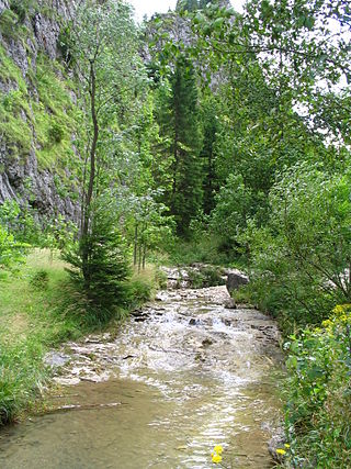
A valley is an elongated low area often running between hills or mountains and typically containing a river or stream running from one end to the other. Most valleys are formed by erosion of the land surface by rivers or streams over a very long period. Some valleys are formed through erosion by glacial ice. These glaciers may remain present in valleys in high mountains or polar areas.

An aquifer is an underground layer of water-bearing material, consisting of permeable or fractured rock, or of unconsolidated materials. Aquifers vary greatly in their characteristics. The study of water flow in aquifers and the characterization of aquifers is called hydrogeology. Related terms include aquitard, which is a bed of low permeability along an aquifer, and aquiclude, which is a solid, impermeable area underlying or overlying an aquifer, the pressure of which could lead to the formation of a confined aquifer. The classification of aquifers is as follows: Saturated versus unsaturated; aquifers versus aquitards; confined versus unconfined; isotropic versus anisotropic; porous, karst, or fractured; transboundary aquifer.

An entrenched river, or entrenched stream is a river or stream that flows in a narrow trench or valley cut into a plain or relatively level upland. Because of lateral erosion streams flowing over gentle slopes over a time develops meandering course. Meanders form where gradient is very gentle, for example in floodplain and delta. Meandering is the feature of the middle and final course of the river. But very deep and wide meanders can also be found cutting hard rocks. Such meanders are called incised or entrenched meanders. The exception is that entrenched meanders are formed during the upliftment of land where river is young. They widen and deepen over time and can be found as deep gorges or canyons in hard rock. In the case of an entrenched stream or river, it is often presumed that the watercourse has inherited its course by cutting down into bedrock from a pre-existing plain with little modification of the original course. The down-cutting of the river system could be the result not only of tectonic uplift but also of other factors such as river piracy, decrease of load, increase of runoff, extension of the drainage basin, or change in base level such as a fall in sea level. General, nongeneric terminology for either a river or stream that flows in a narrow trench or valley, for which evidence of a preexisting plain or relatively level upland can be either absent or present is either valley meander or meander valley with the latter term being preferred in literature.

A subterranean river is a river or watercourse that runs wholly or partly beneath the ground, one where the riverbed does not represent the surface of the Earth. It is distinct from an aquifer, which may flow like a river but is contained within a permeable layer of rock or other unconsolidated materials. A river flowing below ground level in an open gorge is not classed as subterranean.
Landforms are categorized by characteristic physical attributes such as their creating process, shape, elevation, slope, orientation, rock exposure, and soil type.

A spring is a natural exit point at which groundwater emerges from the aquifer and flows onto the top of the Earth's crust (pedosphere) to become surface water. It is a component of the hydrosphere, as well as a part of the water cycle. Springs have long been important for humans as a source of fresh water, especially in arid regions which have relatively little annual rainfall.

A mesa is an isolated, flat-topped elevation, ridge or hill, which is bounded from all sides by steep escarpments and stands distinctly above a surrounding plain. Mesas characteristically consist of flat-lying soft sedimentary rocks capped by a more resistant layer or layers of harder rock, e.g. shales overlain by sandstones. The resistant layer acts as a caprock that forms the flat summit of a mesa. The caprock can consist of either sedimentary rocks such as sandstone and limestone; dissected lava flows; or a deeply eroded duricrust. Unlike plateau, whose usage does not imply horizontal layers of bedrock, e.g. Tibetan Plateau, the term mesa applies exclusively to the landforms built of flat-lying strata. Instead, flat-topped plateaus are specifically known as tablelands.

A cirque is an amphitheatre-like valley formed by glacial erosion. Alternative names for this landform are corrie and cwm. A cirque may also be a similarly shaped landform arising from fluvial erosion.

Glacial landforms are landforms created by the action of glaciers. Most of today's glacial landforms were created by the movement of large ice sheets during the Quaternary glaciations. Some areas, like Fennoscandia and the southern Andes, have extensive occurrences of glacial landforms; other areas, such as the Sahara, display rare and very old fossil glacial landforms.

A water gap is a gap that flowing water has carved through a mountain range or mountain ridge and that still carries water today. Such gaps that no longer carry water currents are called wind gaps. Water gaps and wind gaps often offer a practical route for road and rail transport to cross the mountain barrier.
A ravine is a landform that is narrower than a canyon and is often the product of streambank erosion. Ravines are typically classified as larger in scale than gullies, although smaller than valleys. Ravines may also be called a cleuch, dell, ghout (Nevis), gill or ghyll, glen, gorge, kloof, and chine

A dry valley may develop on many kinds of permeable rock, such as limestone, chalk, sand stone and sandy terrains that do not regularly sustain surface water flow. Such valleys do not hold surface water because it sinks into the permeable bedrock.

Carboniferous Limestone is a collective term for the succession of limestones occurring widely throughout Great Britain and Ireland that were deposited during the Dinantian Epoch of the Carboniferous Period. These rocks formed between 363 and 325 million years ago. Within England and Wales, the entire limestone succession, which includes subordinate mudstones and some thin sandstones, is known as the Carboniferous Limestone Supergroup.

Headward erosion is erosion at the origin of a stream channel, which causes the origin to move back away from the direction of the stream flow, lengthening the stream channel. It can also refer to the widening of a canyon by erosion along its very top edge, when sheets of water first enter the canyon from a more roughly planar surface above it, such as at Canyonlands National Park in Utah. When sheets of water on a roughly planar surface first enter a depression in it, this erodes the top edge of the depression. The stream is forced to grow longer at the very top of the stream, which moves its origin back, or causes the canyon formed by the stream to grow wider as the process repeats. Widening of the canyon by erosion inside the canyon, below the canyon side top edge, or origin or the stream, such as erosion caused by the streamflow inside it, is not called headward erosion.

A river is a natural freshwater stream that flows on land or inside caves towards another body of water at a lower elevation, such as an ocean, lake, or another river. A river may run dry before reaching the end of its course if it runs out of water, or only flow during certain seasons. Rivers are regulated by the water cycle, the processes by which water moves around the Earth. Water first enters rivers through precipitation, whether from rainfall, the runoff of water down a slope, the melting of glaciers or snow, or seepage from aquifers beneath the surface of the Earth.
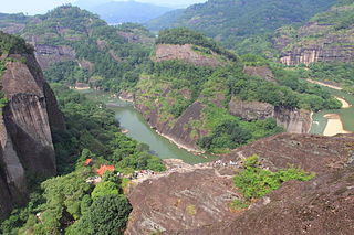
The Danxia landform refers to various landscapes found in southeast, southwest and northwest China that "consist of a red bed characterized by steep cliffs". It is a unique type of petrographic geomorphology found in China. Danxia landform is formed from red-coloured sandstones and conglomerates of largely Cretaceous age. The landforms look very much like karst topography that forms in areas underlain by limestones, but since the rocks that form danxia are sandstones and conglomerates, they have been called "pseudo-karst" landforms. They were formed by endogenous forces and exogenous forces.
This glossary of geography terms is a list of definitions of terms and concepts used in geography and related fields, including Earth science, oceanography, cartography, and human geography, as well as those describing spatial dimension, topographical features, natural resources, and the collection, analysis, and visualization of geographic data. It is split across two articles:

A fissure is a long, narrow crack opening along the surface of Earth. The term is derived from the Latin word fissura, which means 'cleft' or 'crack'. Fissures emerge in Earth's crust, on ice sheets and glaciers, and on volcanoes.
