Lake island

Last updated
Martana island in Lake Bolsena, Italy Isola Martana.jpg
Martana island in Lake Bolsena, Italy

A lake island is any landmass within a lake. It is a type of inland island. Lake islands may form a lake archipelago.

Contents

Formation

Lake islands may form in numerous ways. They may occur through a build-up of sedimentation as shoals, and become true islands through changes in the level of the lake. They may have been originally part of the lake's shore, and been separated from it by erosion, or they may have been left as pinnacles when the lake formed through a raising in the level of a river or other waterway (either naturally, or artificially through the damming of a river or lake). On creation of a glacial lake a moraine can form an island. They may also have formed through earthquake, meteor, or volcanic activity. In the latter case, crater or caldera islands exist, with new volcanic prominences in lakes formed in the craters of larger volcanoes. Other lake islands include ephemeral beds of floating vegetation, and islands artificially formed by human activity.

Volcanic crater and caldera lake islands

Caldera of Cuicocha in Ecuador Laguna de Cuicocha 01.jpg
Caldera of Cuicocha in Ecuador

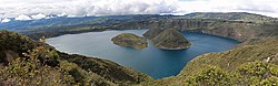
Lakes may sometimes form in the circular depressions of volcanic craters. These craters are typically circular or oval basins around the vent or vents from which magma erupts. A large volcanic eruption sometimes results in the formation of a caldera, caused by the collapse of the magma chamber under the volcano. If enough magma is ejected, the emptied chamber is unable to support the weight of the volcano, and a roughly circular fracture, the ring fault, develops around the edge of the chamber. The centre of the volcano within the ring fracture collapses, creating a ring-shaped depression. Long after the eruption, this caldera may fill with water to become a lake. If volcanic activity continues or restarts, the centre of the caldera may be uplifted in the form of a resurgent dome, to become a crater lake island. Though typically calderas are larger and deeper than craters and form in different ways, a distinction between the two is often ignored in non-technical circumstances and the term crater lake is widely used for the lakes formed in both craters and calderas. The following is a list of large or notable crater lake islands:

Impact crater islands

Impact craters, formed by the collision of large meteorites or comets with the Earth, are relatively uncommon, and those which do exist are frequently heavily eroded or deeply buried. Several, however, do contain lakes. Where the impact crater is complex, a central peak emerges from the floor of the crater. If a lake is present, this central peak may break the water's surface as an island. In other cases, other geological processes may have caused only a ring-shaped annular lake to remain from an impact, with a large central island taking up the remaining area of the crater. The world's largest impact crater island (and the world's second-largest lake island of any kind) is René-Levasseur Island, in Lake Manicouagan, Canada. The Sanshan Islands of Lake Tai, China, are also examples of impact crater islands, as are the islands in Canada's Clearwater Lakes, and the Slate Islands of Lake Superior, also in Canada. Sollerön Island in Siljan Lake, Sweden, and an unnamed island in Lake Karakul, Tajikistan, was also formed by meteor impact.

Floating islands

The Uru people have lived on the Uros floating islands on Lake Titicaca for centuries Uros-floating-islands-puno-peru-aerial.jpg
The Uru people have lived on the Uros floating islands on Lake Titicaca for centuries

The term floating island is sometimes used for accumulations of vegetation free-floating within a body of water. Due to the lack of currents and tides, these are more frequently found in lakes than in rivers or the open sea. Peaty masses of vegetable matter from shallow lake floors may rise due to the accumulation of gases during decomposition, and will often float for a considerable time, becoming ephemeral islands until the gas has dissipated enough for the vegetation to return to the lake floor. [1]

Artificial islands

Artificial or man-made islands are islands constructed by human activity rather than formed by natural means. They may be totally created by humans, enlarged from existing islands or reefs, formed by joining small existing islands, or cut from a mainland (for example, by cutting through the isthmus of a peninsula). Artificial islands have a long history, dating back to the crannogs of prehistoric Britain and Ireland, and the traditional floating Uru islands of Lake Titicaca in South America. Notable early artificial islands include the Aztec city of Tenochtitlan, at the site of modern Mexico City. Though technically caused by human activity, islands formed from hilltops by the deliberate flooding of valleys (such as in the creation of hydroelectricity projects and reservoirs) are not normally regarded as artificial islands.

The artificial island of IJburg, Amsterdam, Netherlands Amsterdam IJburg 20041105.jpg
The artificial island of IJburg, Amsterdam, Netherlands

Artificial islands are built for numerous uses, ranging from flood protection to immigration or quarantine stations. Other uses for reclaimed artificial islands include expansion of living space or transportation centres in densely populated regions. Agricultural land has also been developed through reclamation of polders in the Netherlands and other low lying countries.

Notable modern examples of artificial lake islands include the Dutch polder of Flevopolder in Flevoland, the island of IJburg in Amsterdam, and Flamingo Island in Kamfers Dam, South Africa. At 948 km2 (366 sq mi), Flevopolder, in the now-freshwater lake IJsselmeer, is the largest man-made island in the world.

Former islands

A number of lake islands have disappeared for various reasons. Many lakes have been shrinking, so that some of their islands have become attached to or part of the mainland, such as Vozrozhdeniya Island, Kokaral, Barsa-Kelmes, and others in the Aral Sea; the Bogomerom Archipelago and others in Lake Chad; Shahi Island and others in Lake Urmia; and many others around the world.

Other islands are lost by sinking below the lake surface, either by erosion, subsidence, or rising water level. Sunken Island in Otsego Lake is one example. Islands may also be lost by being artificially attached to the mainland, such as Urk in the former Zuider Zee.

Lists of lake islands

Naturally occurring lake islands by area

There are few naturally occurring lake islands with an area in excess of 270 km2 (100 sq mi). Of these, five are located in the large Great Lakes of North America, three are located in the large African Great Lakes, one is located in the largest lake in Central America, one was formed by the world's fourth largest meteorite impact, and one is located in the largest (by volume) lake in the world.

Coast of Olkhon Island on Lake Baikal Olkhon 2014-06-13 07-38-36 IMG 6874-36-2-2 (32577582872).jpg
Coast of Olkhon Island on Lake Baikal
  1. Manitoulin Island in Lake Huron, Canada2,766 km2 (1,068 sq mi) [2]
  2. René-Levasseur Island in the Manicouagan Reservoir, Quebec, Canada – 2,000 km2 (770 sq mi). [2] It became an artificial island when the Manicouagan Reservoir was flooded in 1970, merging Mouchalagane Lake on the western side and Manicouagan Lake on the eastern side.
  3. Olkhon in Lake Baikal, Russia730 km2 (280 sq mi) [2]
  4. Isle Royale in Lake Superior, United States541 km2 (209 sq mi) [2]
  5. Ukerewe Island in Lake Victoria, Tanzania530 km2 (200 sq mi) [2]
  6. St. Joseph Island in Lake Huron, Canada – 365 km2 (141 sq mi) [2]
  7. Drummond Island in Lake Huron, United States – 347 km2 (134 sq mi) [2]
  8. Idjwi in Lake Kivu, Democratic Republic of the Congo285 km2 (110 sq mi) [2]
  9. Ometepe Island in Lake Nicaragua, Nicaragua276 km2 (107 sq mi) [3]
  10. Bugala Island in Lake Victoria, Uganda – 275 km2 (106 sq mi) [3]
  11. St. Ignace Island in Lake Superior, Canada – 274 km2 (106 sq mi) [3]

Note:

Other lake islands larger than 80 km2 (31 sq mi)

Tallest lake islands

Islands within lakes recursively

Notable island systems and former lake islands

Vanajavesi with its several lake islands in Finland Valkeakoski aerial 1.jpg
Vanajavesi with its several lake islands in Finland

Islands in artificial lakes

See also

Related Research Articles

<span class="mw-page-title-main">Geography of Canada</span>

Canada has a vast geography that occupies much of the continent of North America, sharing a land border with the contiguous United States to the south and the U.S. state of Alaska to the northwest. Canada stretches from the Atlantic Ocean in the east to the Pacific Ocean in the west; to the north lies the Arctic Ocean. Greenland is to the northeast with a shared border on Hans Island. To the southeast Canada shares a maritime boundary with France's overseas collectivity of Saint Pierre and Miquelon, the last vestige of New France. By total area, Canada is the second-largest country in the world, after Russia. By land area alone, however, Canada ranks fourth, the difference being due to it having the world's largest proportion of fresh water lakes. Of Canada's thirteen provinces and territories, only two are landlocked while the other eleven all directly border one of three oceans.

<span class="mw-page-title-main">Canadian Shield</span> Geographic and geologic area of North America

The Canadian Shield, also called the Laurentian Shield or the Laurentian Plateau, is a geologic shield, a large area of exposed Precambrian igneous and high-grade metamorphic rocks. It forms the North American Craton, the ancient geologic core of the North American continent. Glaciation has left the area with only a thin layer of soil, through which exposures of igneous bedrock resulting from its long volcanic history are frequently visible. As a deep, common, joined bedrock region in eastern and central Canada, the shield stretches north from the Great Lakes to the Arctic Ocean, covering over half of Canada and most of Greenland; it also extends south into the northern reaches of the continental United States.

A caldera is a large cauldron-like hollow that forms shortly after the emptying of a magma chamber in a volcanic eruption. An eruption that ejects large volumes of magma over a short period of time can cause significant detriment to the structural integrity of such a chamber, greatly diminishing its capacity to support its own roof, and any substrate or rock resting above. The ground surface then collapses into the emptied or partially emptied magma chamber, leaving a large depression at the surface. Although sometimes described as a crater, the feature is actually a type of sinkhole, as it is formed through subsidence and collapse rather than an explosion or impact. Compared to the thousands of volcanic eruptions that occur over the course of a century, the formation of a caldera is a rare event, occurring only a few times within a given window of 100 years. Only eight caldera-forming collapses are known to have occurred between 1911 and 2018, with a caldera collapse at Kīlauea, Hawaii in 2018. Volcanoes that have formed a caldera are sometimes described as "caldera volcanoes".

<span class="mw-page-title-main">Lake Toba</span> Volcanic lake located in North Sumatra Province, Indonesia

Lake Toba is a large natural lake in North Sumatra, Indonesia, occupying the caldera of the Toba supervolcano. The lake is located in the middle of the northern part of the island of Sumatra, with a surface elevation of about 900 metres (2,953 ft), the lake stretches from 2.88°N 98.52°E to 2.35°N 99.1°E. The lake is about 100 kilometres long, 30 kilometres (19 mi) wide, and up to 505 metres (1,657 ft) deep. It is the largest lake in Indonesia and the largest volcanic lake in the world. Toba Caldera is one of twenty geoparks in Indonesia, and was recognised in July 2020 as one of the UNESCO Global Geoparks.

<span class="mw-page-title-main">Long Valley Caldera</span> Geologic depression near Mammoth Mountain, California, United States

Long Valley Caldera is a depression in eastern California that is adjacent to Mammoth Mountain. The valley is one of the Earth's largest calderas, measuring about 20 mi (32 km) long (east-west), 11 mi (18 km) wide (north-south), and up to 3,000 ft (910 m) deep.

<span class="mw-page-title-main">Northeastern Manitoulin and the Islands</span> Town in Ontario, Canada

Northeastern Manitoulin and the Islands is a municipality with town status in Manitoulin District in Northeastern Ontario, Canada, approximately 30 kilometres (19 mi) south of Espanola. Its main town is Little Current, located on the northeast side of Manitoulin Island. However, its territory also includes most of the small islands surrounding Manitoulin, even those at the far western end of Manitoulin.

<span class="mw-page-title-main">Manicouagan Reservoir</span> Lake in Quebec, Canada

Manicouagan Reservoir is an annular lake in central Quebec, Canada, covering an area of 1,942 km2 (750 sq mi). The lake island in its centre is known as René-Levasseur Island, and its highest point is Mount Babel. The structure was created 214 (±1) million years ago, in the Late Triassic, by the impact of a meteorite 5 km (3 mi) in diameter. The lake and island are clearly seen from space and are sometimes called the "eye of Quebec". The lake has a volume of 137.9 km3 (33.1 cu mi).

<span class="mw-page-title-main">Ambrym</span> Volcanic island in Vanuatu

Ambrym is a volcanic island in Malampa Province in the archipelago of Vanuatu. Volcanic activity on the island includes lava lakes in two craters near the summit.

<span class="mw-page-title-main">Masaya Volcano</span> Active complex volcano in Nicaragua

Masaya is a caldera located in Masaya, Nicaragua, 20 km (12 mi) south of the capital Managua. It is Nicaragua's first and largest national park, and one of 78 protected areas of Nicaragua. The complex volcano is composed of a nested set of calderas and craters, the largest of which is Las Sierras shield volcano and caldera. Within this caldera lies a sub-vent, which is Masaya Volcano sensu stricto. The vent is a shield type composed of basaltic lavas and tephras and includes a summit crater. This hosts Masaya caldera, formed 2,500 years ago by an 8 km3 (1.9 cu mi) basaltic ignimbrite eruption. Inside this caldera a new basaltic complex has grown from eruptions mainly on a semi-circular set of vents that include the Masaya and Nindiri cones. The latter host the pit craters of Masaya, Santiago, Nindiri and San Pedro. Observations in the walls of the pit craters indicate that there have been several episodes of cone and pit crater formation.

<span class="mw-page-title-main">René-Levasseur Island</span> Lake island in Quebec, Canada

René-Levasseur Island is a large island in the centre of Lake Manicouagan in Quebec, Canada. Its highest peak is Mount Babel, at 952 m, which is contained in the Louis-Babel Ecological Reserve. With a total area of 2,020 km2, the island is larger in area than the annular lake in which it is situated. René-Levasseur Island is the world's second-largest lake island.

<span class="mw-page-title-main">Sääminginsalo</span> Island in Finland

Sääminginsalo has been said to be the largest true island of Finland. If it is considered as an island, it is the third largest island in a lake in the world. This inland island is located in Southern Savonia region, Eastern Finland and is surrounded by the lake Greater Saimaa, and an artificial canal, Raikuun kanava, that was built in 1750s. The most famous sight on Sääminginsalo is the Kerimäki Church, the largest wooden church in the world.

<span class="mw-page-title-main">Nettilling Lake</span> Lake in Nunavut, Canada

Nettilling Lake is a cold freshwater lake located toward the south end of Baffin Island in the Qikiqtaaluk Region, Nunavut, Canada. It is the 30th largest lake in the world by area, and the world's largest lake on an island, with an area of 5,542 km2 (2,140 sq mi) and a maximum length of 123 km (76 mi). The lake is in the Great Plain of the Koukdjuak about 280 km (170 mi) northwest of Iqaluit. The Arctic Circle crosses the lake. The lake's name is of Inuktitut origin, coming from the word for the adult ringed seal (netsilak). Franz Boas explored its southern shore in 1884.

<span class="mw-page-title-main">Billy Mitchell (volcano)</span> Crater lake in Bougainville Island

Billy Mitchell is a pyroclastic shield in the central part of the island of Bougainville, just north-east of the Bagana Volcano in Papua New Guinea. It is a small pyroclastic shield truncated by a 2 km wide caldera filled by a crater lake. It is named after Billy Mitchell, a 20th-century United States Army general who is regarded as the father of the United States Air Force.

<span class="mw-page-title-main">Cameroon line</span> Chain of volcanoes in the Gulf of Guinea

The Cameroon line is a 1,600 km (1,000 mi) long chain of volcanoes that includes islands in the Gulf of Guinea and mountains on the African mainland, from Mount Cameroon on the coast towards Lake Chad on the northeast. They form a natural border between eastern Nigeria and the West Region of Cameroon. The islands, which span the equator, have tropical climates and are home to many unique plant and bird species. The mainland mountain regions are much cooler than the surrounding lowlands, and also contain unique and ecologically important environments.

<span class="mw-page-title-main">Lake</span> Large inland body of relatively still water

A lake is an often naturally occurring, relatively large and fixed body of water on or near the Earth's surface. It is localized in a basin or interconnected basins surrounded by dry land. Lakes lie completely on land and are separate from the ocean, although they may be connected with the ocean by rivers. Lakes, as with other bodies of water, are part of the water cycle, the processes by which water moves around the Earth. Most lakes are fresh water and account for almost all the world's surface freshwater, but some are salt lakes with salinities even higher than that of seawater. Lakes vary significantly in surface area and volume of water.

<span class="mw-page-title-main">Lake Nemrut</span> Freshwater crater lake in Bitlis Province, eastern Turkey

Lake Nemrut is a freshwater crater lake in Bitlis Province, eastern Turkey. It is part of Nemrut Caldera, a volcanic caldera atop Volcano Nemrut.

<span class="mw-page-title-main">Santorini caldera</span> Submerged caldera in the Aegean Sea

Santorini caldera is a large, mostly submerged caldera, located in the southern Aegean Sea, 120 kilometers north of Crete in Greece. Visible above water is the circular Santorini island group, consisting of Santorini, the main island, Therasia and Aspronisi at the periphery, and the Kameni islands at the center. It has been designated a Decade Volcano.

<span class="mw-page-title-main">Kurile Lake</span> Caldera lake in the Kamchatka peninsula, Russia

Kurile Lake is a caldera and crater lake in Kamchatka, Russia. It is also known as Kurilskoye Lake or Kuril Lake. It is part of the Eastern Volcanic Zone of Kamchatka which, together with the Sredinny Range, forms one of the volcanic belts of Kamchatka. These volcanoes form from the subduction of the Pacific Plate beneath the Okhotsk Plate and the Asian Plate.

<span class="mw-page-title-main">Volcanic crater lake</span> Lake formed within a volcanic crater

A volcanic crater lake is a lake in a crater that was formed by explosive activity or a collapse during a volcanic eruption.

A recursive island or lake, also known as a nested island or lake, is an island or a lake that lies within a lake or an island. For the purposes of defining recursion, small continental land masses such as Madagascar and New Zealand count as islands, while large continental land masses do not. Islands found within lakes in these countries are often recursive islands because the lake itself is located on an island.

References

  1. Marr, J.E. (1900). The scientific study of scenery. London: Methuen.
  2. 1 2 3 4 5 6 7 8 9 "Islands of the World: Largest Lake Islands". World Atlas. Retrieved 15 February 2010.
  3. 1 2 3 4 5 6 7 8 9 10 11 "Largest Lake Islands of the World". WorldIslandInfo.com. Archived from the original on 28 September 2011. Retrieved 15 February 2010.
  4. 1 2 3 Sarjakoski, Tapani (1996). "Chapter 20.3 - How many lakes, rivers and islands are there in Finland?". In Peter A. Burrough and Andrew U. Frank (ed.). Geographic Objects with Indeterminate Boundaries. Taylor & Francis. pp. 302–304. ISBN   9780748403875 . Retrieved 2019-05-06.
  5. 1 2 "Largest Islands in Finland (in Finnish)". Archived from the original on 12 April 2010. Retrieved 26 February 2010.
  6. 1 2 3 4 5 "Some interesting islands and lakes". Elbruz. Retrieved 2014-02-01.
  7. Nisos Ioanninon article (in Greek)