Glacial lake

Last updated
The Seven Rila Lakes in Rila mountain, Bulgaria, are of glacial origin. Rila 7 lakes circus panorama edit1.jpg
The Seven Rila Lakes in Rila mountain, Bulgaria, are of glacial origin.
The Great Lakes as seen from space. The Great Lakes are the largest glacial lakes in the world. Great Lakes from space.jpg
The Great Lakes as seen from space. The Great Lakes are the largest glacial lakes in the world.
The prehistoric glacial lake Agassiz once held more water than contained by all lakes in the world today. Agassiz.jpg
The prehistoric glacial lake Agassiz once held more water than contained by all lakes in the world today.

A glacial lake is a body of water with origins from glacier activity. They are formed when a glacier erodes the land and then melts, filling the depression created by the glacier. [1]

Contents

Formation

Near the end of the last glacial period, roughly 10,000 years ago, glaciers began to retreat. [2] A retreating glacier often left behind large deposits of ice in hollows between drumlins or hills. As the ice age ended, these melted to create lakes. This is apparent in the Lake District in Northwestern England where post-glacial sediments are normally between 4 and 6 metres deep. [2] These lakes are often surrounded by drumlins, along with other evidence of the glacier such as moraines, eskers and erosional features such as striations and chatter marks.

These lakes are clearly visible in aerial photos of landforms in regions that were glaciated during the last ice age.[ citation needed ]

The formation and characteristics of glacial lakes vary between location and can be classified into glacial erosion lake, ice-blocked lake, moraine-dammed lake, other glacial lake, supraglacial lake, and subglacial lake. [1]

Glacial lakes and changing climate

Since the glaciation of the Little Ice Age, Earth has lost more than 50% of its glaciers. This along with the current increase in retreating glaciers caused by climate change has created a shift from frozen to liquid water, increasing the extent and volume of glacial lakes around the world. Most glacial lakes present today can be found in Asia, Europe, and North America. The area which will see the greatest increase in lake formation is the Southern Tibetan Plateau region from debris covered glaciers. [3] This increase in glacial lake formation also indicates an increase in occurrence of glacial lake outburst flood events caused by damming and subsequent breaking of moraine and ice.

Sediments

The amount of sediment found in glacial lakes varies, and has a general stratigraphic sequence of organic muds, glacial clays, silty clays, and sands based on time of formation. [4]

Over time the glacial lake sediments are subjected to change. As seen in the English Lake District, the layers of the sediments at the bottom of the lakes contain evidence of the rate of erosion. The elemental make up of the sediments are not associated with the lakes themselves, but by the migration of the elements within the soil, such as iron and manganese.

The distribution of these elements, within the lake bed, are attributed to the condition of the drainage basin and the chemical composition of the water.

Sediment deposition can also be influenced by animal activity; including the distribution of biochemical elements, which are elements that are found in organic organisms, such as phosphorus and sulfur.

The amount of halogens and boron found in the sediments accompanies a change in erosional activity. The rate of deposition reflects the amount of halogen and boron in the deposited sediments. [2]

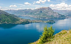
The scouring action of the glaciers pulverizes minerals in the rock over which the glacier passes. These pulverized minerals become sediment at the bottom of the lake, and some of the rock flour becomes suspended in the water column. These suspended minerals support a large population of algae, making the water appear green. [5]

Glacial lake sediments also archive changes in geochemistry and pollen records as a result of climate change and human activities. During the transition from the Last Glacial Period to the Holocene climatic optimum, soil development was enhanced, whereas early human activities such as deforestation have resulted in elevated soil erosion. These events can be reflected in geochemistry and isotope signatures in the lake sediments. [6]

Biotic ecosystem

Seal at Jokulsarlon glacial lagoon in Iceland A Seal at the Glacial Lagoon.jpg
Seal at Jökulsárlón glacial lagoon in Iceland

Biodiversity and productivity tend to be lower in glacial lakes as only cold-tolerant and cold-adapted species can withstand their harsh conditions. Glacial rock flour and low nutrient levels create an oligotrophic environment where few species of plankton, fish and benthic organisms reside. [7]

Before becoming a lake the first stages of glacial recession melt enough freshwater to form a shallow lagoon. In the case of Iceland's Jökulsárlón glacial lagoon located on the edge of the Atlantic Ocean, tides bring in an array of fish species to the edge of the glacier. These fish attract an abundance of predators from birds to marine mammals, that are searching for food. These predators include fauna such as, seals, arctic terns and arctic skua. [8]

Glacial lakes that have been formed for a long period of time have a more diverse ecosystem of fauna originating form neighboring tributaries or other glacial refugia. For example, many native species of the great lakes basin entered via the Mississippi basin refugia within the past 14,000 years. [9]

Societal perspectives

Argentino glacial lake at the base of Perito Moreno glacier in Argentina Perito moreno.jpg
Argentino glacial lake at the base of Perito Moreno glacier in Argentina

Glacial lakes act as fresh water storage for the replenishing of a region's water supply and serve as potential electricity producers from hydropower.

Glacial lakes' aesthetic nature can also stimulate economic activity through the attraction of the tourism industry. [10] Thousands of tourists visit the Jökulsárlón glacial lagoon in Iceland annually to take part in commercial boat tours and every two to four years thousands visit the Argentino glacial lake in Argentina to witness the collapse of the cyclically formed arch of ice from the Perito Moreno glacier, making it one of the largest travel destinations in Patagonia. [11] [12]

See also

Related Research Articles

<span class="mw-page-title-main">Glacier</span> Persistent body of ice that is moving under its own weight

A glacier is a persistent body of dense ice that is constantly moving under its own weight. A glacier forms where the accumulation of snow exceeds its ablation over many years, often centuries. It acquires distinguishing features, such as crevasses and seracs, as it slowly flows and deforms under stresses induced by its weight. As it moves, it abrades rock and debris from its substrate to create landforms such as cirques, moraines, or fjords. Although a glacier may flow into a body of water, it forms only on land and is distinct from the much thinner sea ice and lake ice that form on the surface of bodies of water.

<span class="mw-page-title-main">Drumlin</span> Elongated hill formed by glacial action

A drumlin, from the Irish word droimnín, first recorded in 1833, in the classical sense is an elongated hill in the shape of an inverted spoon or half-buried egg formed by glacial ice acting on underlying unconsolidated till or ground moraine. Assemblages of drumlins are referred to as fields or swarms; they can create a landscape which is often described as having a 'basket of eggs topography'.

<span class="mw-page-title-main">Moraine</span> Glacially formed accumulation of debris

A moraine is any accumulation of unconsolidated debris, sometimes referred to as glacial till, that occurs in both currently and formerly glaciated regions, and that has been previously carried along by a glacier or ice sheet. It may consist of partly rounded particles ranging in size from boulders down to gravel and sand, in a groundmass of finely-divided clayey material sometimes called glacial flour. Lateral moraines are those formed at the side of the ice flow, and terminal moraines were formed at the foot, marking the maximum advance of the glacier. Other types of moraine include ground moraines and medial moraines.

<span class="mw-page-title-main">Till</span> Unsorted glacial sediment

Till or glacial till is unsorted glacial sediment.

<span class="mw-page-title-main">Glaciology</span> Scientific study of ice and natural phenomena involving ice

Glaciology is the scientific study of glaciers, or more generally ice and natural phenomena that involve ice.

Landforms are categorized by characteristic physical attributes such as their creating process, shape, elevation, slope, orientation, rock exposure, and soil type.

<span class="mw-page-title-main">Jökulhlaup</span> Type of glacial outburst flood

A jökulhlaup is a type of glacial outburst flood. It is an Icelandic term that has been adopted in glaciological terminology in many languages. It originally referred to the well-known subglacial outburst floods from Vatnajökull, Iceland, which are triggered by geothermal heating and occasionally by a volcanic subglacial eruption, but it is now used to describe any large and abrupt release of water from a subglacial or proglacial lake/reservoir.

<span class="mw-page-title-main">Glacial erratic</span> Piece of rock that has been moved by a glacier

A glacial erratic is a glacially deposited rock differing from the type of rock native to the area in which it rests. Erratics, which take their name from the Latin word errare, are carried by glacial ice, often over distances of hundreds of kilometres. Erratics can range in size from pebbles to large boulders such as Big Rock in Alberta.

<span class="mw-page-title-main">Outwash plain</span> Plain formed from glacier sediment transported by meltwater

An outwash plain, also called a sandur, sandr or sandar, is a plain formed of glaciofluvial deposits due to meltwater outwash at the terminus of a glacier. As it flows, the glacier grinds the underlying rock surface and carries the debris along. The meltwater at the snout of the glacier deposits its load of sediment over the outwash plain, with larger boulders being deposited near the terminal moraine, and smaller particles travelling further before being deposited. Sandurs are common in Iceland where geothermal activity accelerates the melting of ice flows and the deposition of sediment by meltwater.

<span class="mw-page-title-main">Till plain</span> Plain of glacial till

Till plains are an extensive flat plain of glacial till that forms when a sheet of ice becomes detached from the main body of a glacier and melts in place, depositing the sediments it carried. Ground moraines are formed with melts out of the glacier in irregular heaps, forming rolling hills. Till plains are common in areas such as the Midwestern United States, due to multiple glaciation events that occurred in the Holocene epoch. During this period, the Laurentide Ice Sheet advanced and retreated during the Pleistocene epoch. Till plains formed by the Wisconsin glaciation cover much of the Midwest, including North Dakota, South Dakota, Indiana, Minnesota, Wisconsin, Iowa, Illinois, and northern Ohio.

<span class="mw-page-title-main">Glacial motion</span> Geological phenomenon

Glacial motion is the motion of glaciers, which can be likened to rivers of ice. It has played an important role in sculpting many landscapes. Most lakes in the world occupy basins scoured out by glaciers. Glacial motion can be fast or slow, but is typically around 25 centimetres per day (9.8 in/d).

<span class="mw-page-title-main">Glacial landform</span> Landform created by the action of glaciers

Glacial landforms are landforms created by the action of glaciers. Most of today's glacial landforms were created by the movement of large ice sheets during the Quaternary glaciations. Some areas, like Fennoscandia and the southern Andes, have extensive occurrences of glacial landforms; other areas, such as the Sahara, display rare and very old fossil glacial landforms.

The Oak Ridges Moraine is a geological landform that runs east-west across south central Ontario, Canada. It developed about 12,000 years ago, during the Wisconsin glaciation in North America. A complex ridge of sedimentary material, the moraine is known to have partially developed under water. The Niagara Escarpment played a key role in forming the moraine in that it acted as a dam for glacial meltwater trapped between it and two ice lobes.

<span class="mw-page-title-main">Glacial lake outburst flood</span> Type of outburst flood that occurs when the dam containing a glacial lake fails

A glacial lake outburst flood (GLOF) is a type of outburst flood caused by the failure of a dam containing a glacial lake. An event similar to a GLOF, where a body of water contained by a glacier melts or overflows the glacier, is called a jökulhlaup. The dam can consist of glacier ice or a terminal moraine. Failure can happen due to erosion, a buildup of water pressure, an avalanche of rock or heavy snow, an earthquake or cryoseism, volcanic eruptions under the ice, or massive displacement of water in a glacial lake when a large portion of an adjacent glacier collapses into it.

<span class="mw-page-title-main">Tunnel valley</span> Glacial-formed geographic feature

A tunnel valley is a U-shaped valley originally cut under the glacial ice near the margin of continental ice sheets such as that now covering Antarctica and formerly covering portions of all continents during past glacial ages. They can be as long as 100 km (62 mi), 4 km (2.5 mi) wide, and 400 m (1,300 ft) deep.

<span class="mw-page-title-main">U-shaped valley</span> Valleys formed by glacial scouring

U-shaped valleys, also called trough valleys or glacial troughs, are formed by the process of glaciation. They are characteristic of mountain glaciation in particular. They have a characteristic U shape in cross-section, with steep, straight sides and a flat or rounded bottom. Glaciated valleys are formed when a glacier travels across and down a slope, carving the valley by the action of scouring. When the ice recedes or thaws, the valley remains, often littered with small boulders that were transported within the ice, called glacial till or glacial erratic.

<span class="mw-page-title-main">Rogen moraine</span> Landform of ridges deposited by a glacier or ice sheet transverse to ice flow

A Rogen moraine is a subglacially formed type of moraine landform, that mainly occurs in Fennoscandia, Scotland, Ireland and Canada. It is one of the three main types of hummocky moraines. They cover large areas that have been covered by ice, and occur mostly in what is believed to have been the central areas of the ice sheets. Rogen moraines are named after Lake Rogen in Härjedalen, Sweden, the landform's type locality. Rogen Nature Reserve serves to protect the unusual area.

<span class="mw-page-title-main">Withrow Moraine and Jameson Lake Drumlin Field</span>

The Withrow Moraine and Jameson Lake Drumlin Field is a National Park Service–designated privately owned National Natural Landmark located in Douglas County, Washington state, United States. Withrow Moraine is the only Ice Age terminal moraine on the Waterville Plateau section of the Columbia Plateau. The drumlin field includes excellent examples of glacially-formed elongated hills.

Fluvioglacial landforms or glaciofluvial landforms are those that result from the associated erosion and deposition of sediments caused by glacial meltwater. Glaciers contain suspended sediment loads, much of which is initially picked up from the underlying landmass. Landforms are shaped by glacial erosion through processes such as glacial quarrying, abrasion, and meltwater. Glacial meltwater contributes to the erosion of bedrock through both mechanical and chemical processes. Fluvio-glacial processes can occur on the surface and within the glacier. The deposits that happen within the glacier are revealed after the entire glacier melts or partially retreats. Fluvio-glacial landforms and erosional surfaces include: outwash plains, kames, kame terraces, kettle holes, eskers, varves, and proglacial lakes.

<span class="mw-page-title-main">Overdeepening</span> Characteristic of basins and valleys eroded by glaciers

Overdeepening is a characteristic of basins and valleys eroded by glaciers. An overdeepened valley profile is often eroded to depths which are hundreds of metres below the lowest continuous surface line along a valley or watercourse. This phenomenon is observed under modern day glaciers, in salt-water fjords and fresh-water lakes remaining after glaciers melt, as well as in tunnel valleys which are partially or totally filled with sediment. When the channel produced by a glacier is filled with debris, the subsurface geomorphic structure is found to be erosionally cut into bedrock and subsequently filled by sediments. These overdeepened cuts into bedrock structures can reach a depth of several hundred metres below the valley floor.

References

  1. 1 2 Yao, Xiaojun; Liu, Shiyin; Han, Lei; Sun, Meiping; Zhao, Linlin (2018-02-01). "Definition and classification system of glacial lake for inventory and hazards study". Journal of Geographical Sciences. 28 (2): 193–205. doi: 10.1007/s11442-018-1467-z .
  2. 1 2 3 MacKereth, F. J. H. (1966). "Some chemical observations on post-glacial lake sediments". Philosophical Transactions of the Royal Society of London. Series B, Biological Sciences. 250 (765): 165–213. Bibcode:1966RSPTB.250..165M. doi:10.1098/rstb.1966.0001.
  3. Buckel, J.; Otto, J.C.; Prasicek, G.; Keuschnig, M. (2018). "Glacial lakes in Austria - Distribution and formation since the Little Ice Age". Global and Planetary Change. 164: 39–51. Bibcode:2018GPC...164...39B. doi: 10.1016/j.gloplacha.2018.03.003 .
  4. Mackereth F. J. H.; Cooper Leslie Hugh Norman (1966-03-17). "Some chemical observations on post-glacial lake sediments". Philosophical Transactions of the Royal Society of London. Series B, Biological Sciences. 250 (765): 165–213. Bibcode:1966RSPTB.250..165M. doi:10.1098/rstb.1966.0001.
  5. Nova, Mystery of the Mega flood, , PBS
  6. Zhang, Xu (Yvon); Bajard, Manon; Bouchez, Julien; Sabatier, Pierre; Poulenard, Jérôme; Arnaud, Fabien; Crouzet, Christian; Kuessner, Marie; Dellinger, Mathieu; Gaillardet, Jérôme (2023-12-15). "Evolution of the alpine Critical Zone since the Last Glacial Period using Li isotopes from lake sediments". Earth and Planetary Science Letters. 624: 118463. doi:10.1016/j.epsl.2023.118463. ISSN   0012-821X.
  7. Netto, Renata G.; Benner, Jacob S.; Buatois, Luis A.; Uchman, Alfred; Mángano, M. Gabriela; Ridge, John C.; Kazakauskas, Vaidotas; Gaigalas, Algirdas (2012). "Glacial Environments". Trace Fossils as Indicators of Sedimentary Environments. Developments in Sedimentology. Vol. 64. pp. 299–327. doi:10.1016/b978-0-444-53813-0.00011-3. ISBN   978-0-444-53813-0.
  8. Evans, Andrew (2008). Iceland: The Bradt Travel Guide. Bradt Travel Guides. ISBN   9781841622156.
  9. Bailey, Reeve M.; Smith, Gerald R. (1981-12-01). "Origin and Geography of the Fish Fauna of the Laurentian Great Lakes Basin". Canadian Journal of Fisheries and Aquatic Sciences. 38 (12): 1539–1561. doi:10.1139/f81-206.
  10. Harrison, Stephan; Holloway, Max; Singarayer, Joy; Duller, Geoffrey A. T.; Jansson, Krister N.; Glasser, Neil F. (2016-02-12). "Glacial lake drainage in Patagonia (13-8 kyr) and response of the adjacent Pacific Ocean". Scientific Reports. 6: 21064. Bibcode:2016NatSR...621064G. doi:10.1038/srep21064. PMC   4751529 . PMID   26869235.
  11. "About The Glacier Lagoon". icelagoon.is. Retrieved 2019-03-18.
  12. "Why This Massive Glacial Arch Collapses Like Clockwork". Travel. 2018-03-13. Archived from the original on March 16, 2018. Retrieved 2019-03-18.