Glacier terminus

Last updated
A glacial terminus Easton Glacier 3444.JPG
A glacial terminus
Satellite view of changing glacier termini in the Bhutan-Himalaya, showing glacial lakes formed by the retreating termini on the surface of the debris-covered glaciers over the last several decades. Glacial lakes, Bhutan.jpg
Satellite view of changing glacier termini in the Bhutan-Himalaya, showing glacial lakes formed by the retreating termini on the surface of the debris-covered glaciers over the last several decades.

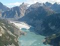
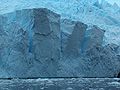
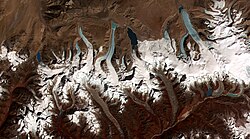
A glacier terminus, toe, or snout, is the end of a glacier at any given point in time. Although glaciers seem motionless to the observer, in reality they are in endless motion and the glacier terminus is always either advancing or retreating. The location of the terminus is often directly related to glacier mass balance, which is based on the amount of snowfall which occurs in the accumulation zone of a glacier, as compared to the amount that is melted in the ablation zone. The position of a glacier terminus is also impacted by localized or regional temperature change over time. [1]

Contents

Tracking

Tracking the change in location of a glacier terminus is a method of monitoring a glacier's movement. The end of the glacier terminus is measured from a fixed position in neighboring bedrock periodically over time. The difference in location of a glacier terminus as measured from this fixed position at different time intervals provides a record of the glacier's change. A similar way of tracking glacier change is comparing photographs of the glacier's position at different times. [2]

The form of a glacier terminus is determined by many factors. If the glacier is retreating, it is usually mildly sloping in form because a melting glacier tends to assume this shape. But there are many conditions that alter this typical shape, including the presence of thermal fields and various stresses that cause cracking and melting feedback resulting in glacial calving and other diverse forms. [3]

See also

Notes

  1. "All About Glaciers - Glacier Terminus". National Snow and Ice Data Center. Archived from the original on 2007-12-21. Retrieved 2007-11-25.
  2. "Techniques for studying glacier change". Archived from the original on September 3, 2006. Retrieved 2007-03-21.
  3. "Glossary of Selected Glacier and Related Terminology". USGS. Retrieved 2007-11-25.

Related Research Articles

<span class="mw-page-title-main">Glacier</span> Persistent body of ice that is moving under its own weight

A glacier is a persistent body of dense ice that is constantly moving under its own weight. A glacier forms where the accumulation of snow exceeds its ablation over many years, often centuries. It acquires distinguishing features, such as crevasses and seracs, as it slowly flows and deforms under stresses induced by its weight. As it moves, it abrades rock and debris from its substrate to create landforms such as cirques, moraines, or fjords. Although a glacier may flow into a body of water, it forms only on land and is distinct from the much thinner sea ice and lake ice that form on the surface of bodies of water.

<span class="mw-page-title-main">Moraine</span> Glacially formed accumulation of debris

A moraine is any accumulation of unconsolidated debris, sometimes referred to as glacial till, that occurs in both currently and formerly glaciated regions, and that has been previously carried along by a glacier or ice sheet. It may consist of partly rounded particles ranging in size from boulders down to gravel and sand, in a groundmass of finely-divided clayey material sometimes called glacial flour. Lateral moraines are those formed at the side of the ice flow, and terminal moraines were formed at the foot, marking the maximum advance of the glacier. Other types of moraine include ground moraines and medial moraines.

<span class="mw-page-title-main">Sea level</span> Geographical reference point from which various heights are measured

Mean sea level is an average surface level of one or more among Earth's coastal bodies of water from which heights such as elevation may be measured. The global MSL is a type of vertical datum – a standardised geodetic datum – that is used, for example, as a chart datum in cartography and marine navigation, or, in aviation, as the standard sea level at which atmospheric pressure is measured to calibrate altitude and, consequently, aircraft flight levels. A common and relatively straightforward mean sea-level standard is instead the midpoint between a mean low and mean high tide at a particular location.

<span class="mw-page-title-main">Outwash plain</span> Plain formed from glacier sediment transported by meltwater

An outwash plain, also called a sandur, sandr or sandar, is a plain formed of glaciofluvial deposits due to meltwater outwash at the terminus of a glacier. As it flows, the glacier grinds the underlying rock surface and carries the debris along. The meltwater at the snout of the glacier deposits its load of sediment over the outwash plain, with larger boulders being deposited near the terminal moraine, and smaller particles travelling further before being deposited. Sandurs are common in Iceland where geothermal activity accelerates the melting of ice flows and the deposition of sediment by meltwater.

<span class="mw-page-title-main">Snow line</span> Boundary between a snow-covered and snow-free surface

The climatic snow line is the boundary between a snow-covered and snow-free surface. The actual snow line may adjust seasonally, and be either significantly higher in elevation, or lower. The permanent snow line is the level above which snow will lie all year.

<span class="mw-page-title-main">Mendenhall Glacier</span> Glacier in the United States

Mendenhall Glacier is a glacier about 13.6 miles (21.9 km) long located in Mendenhall Valley, about 12 miles (19 km) from downtown Juneau in the southeast area of the U.S. state of Alaska. The glacier and surrounding landscape is protected as part of the 5,815 acres (2,353 ha) Mendenhall Glacier Recreation Area, a federally designated unit of the Tongass National Forest.

<span class="mw-page-title-main">Hooker Glacier (New Zealand)</span> Glacier in New Zealand

Hooker Glacier is one of several glaciers close to the slopes of Aoraki / Mount Cook in the Southern Alps of New Zealand. It is not as large as its neighbour, the Tasman Glacier, measuring 11 kilometres in length.

In glaciology, starvation occurs when a glacier retreats, not because of temperature increases, but due to precipitation so low that the ice flow downward into the zone of ablation exceeds the replenishment from snowfall. Eventually, the ice will move so far down that it either calves into the ocean or melts.

<span class="mw-page-title-main">Glacier mass balance</span> Difference between accumulation and melting on a glacier

Crucial to the survival of a glacier is its mass balance of which surface mass balance (SMB), the difference between accumulation and ablation. Climate change may cause variations in both temperature and snowfall, causing changes in the surface mass balance. Changes in mass balance control a glacier's long-term behavior and are the most sensitive climate indicators on a glacier. From 1980 to 2012 the mean cumulative mass loss of glaciers reporting mass balance to the World Glacier Monitoring Service is −16 m. This includes 23 consecutive years of negative mass balances.

<span class="mw-page-title-main">Retreat of glaciers since 1850</span> Shortening of glaciers by melting

The retreat of glaciers since 1850 is well documented and is one of the effects of climate change. The retreat of mountain glaciers, notably in western North America, Asia, the Alps and tropical and subtropical regions of South America, Africa and Indonesia, provide evidence for the rise in global temperatures since the late 19th century. The acceleration of the rate of retreat since 1995 of key outlet glaciers of the Greenland and West Antarctic ice sheets may foreshadow a rise in sea level, which would affect coastal regions. Excluding peripheral glaciers of ice sheets, the total cumulated global glacial losses over the 26 year period from 1993–2018 were likely 5500 gigatons, or 210 gigatons per yr.

<span class="mw-page-title-main">Grinnell Glacier</span> Glacier in Glacier National Park, Montana, United States

Grinnell Glacier is in the heart of Glacier National Park in the U.S. state of Montana. The glacier is named for George Bird Grinnell, an early American conservationist and explorer, who was also a strong advocate of ensuring the creation of Glacier National Park. The glacier is in the Lewis Range and rests on the north flank of Mount Gould at an altitude averaging 7,000 feet (2,100 m), in the Many Glacier region of the park.

<span class="mw-page-title-main">Glacier cave</span> Cave formed within the ice of a glacier

A glacier cave is a cave formed within the ice of a glacier. Glacier caves are often called ice caves, but the latter term is properly used to describe bedrock caves that contain year-round ice.

<span class="mw-page-title-main">Whitney Glacier</span>

The Whitney Glacier is a glacier situated on Mount Shasta, in the U.S. state of California. The Whitney Glacier is the longest glacier and the only valley glacier in California. In area and volume, it ranks second in the state behind the nearby Hotlum Glacier. In 1986, the glacier was measured to be 126 ft (38 m) deep and over three km in length. The glacier starts on Mount Shasta's Misery Hill at 13,700 ft (4,200 m) and flows northwestward down to the saddle between Mount Shasta and Shastina, where uneven ground causes a major icefall at 11,800 ft (3,600 m). It then flows down the valley between the two peaks, reaching its terminus at 9,500 to 9,800 ft.

<span class="mw-page-title-main">Tidewater glacier cycle</span> Behavior of glaciers that terminate at the sea

The tidewater glacier cycle is the typically centuries-long behavior of tidewater glaciers that consists of recurring periods of advance alternating with rapid retreat and punctuated by periods of stability. During portions of its cycle, a tidewater glacier is relatively insensitive to climate change.

<span class="mw-page-title-main">Glaciers of New Zealand</span>

New Zealand contains many glaciers, mostly located near the Main Divide of the Southern Alps in the South Island. They are classed as mid-latitude mountain glaciers. There are eight small glaciers in the North Island on Mount Ruapehu.

<span class="mw-page-title-main">Petermann Glacier</span> Glacier in Greenland

Petermann Glacier is a large glacier located in North-West Greenland to the east of Nares Strait. It connects the Greenland ice sheet to the Arctic Ocean at 81°10' north latitude, near Hans Island.

Subglacial streams are conduits of glacial meltwater that flow at the base of glaciers and ice caps. Meltwater from the glacial surface travels downward throughout the glacier, forming an englacial drainage system consisting of a network of passages that eventually reach the bedrock below, where they form subglacial streams. Subglacial streams form a system of tunnels and interlinked cavities and conduits, with water flowing under extreme pressures from the ice above; as a result, flow direction is determined by the pressure gradient from the ice and the topography of the bed rather than gravity. Subglacial streams form a dynamic system that is responsive to changing conditions, and the system can change significantly in response to seasonal variation in meltwater and temperature. Water from subglacial streams is routed towards the glacial terminus, where it exits the glacier. Discharge from subglacial streams can have a significant impact on local, and in some cases global, environmental and geological conditions. Sediments, nutrients, and organic matter contained in the meltwater can all influence downstream and marine conditions. Climate change may have a significant impact on subglacial stream systems, increasing the volume of meltwater entering subglacial drainage systems and influencing their hydrology.

Deglaciation is the transition from full glacial conditions during ice ages, to warm interglacials, characterized by global warming and sea level rise due to change in continental ice volume. Thus, it refers to the retreat of a glacier, an ice sheet or frozen surface layer, and the resulting exposure of the Earth's surface. The decline of the cryosphere due to ablation can occur on any scale from global to localized to a particular glacier. After the Last Glacial Maximum, the last deglaciation begun, which lasted until the early Holocene. Around much of Earth, deglaciation during the last 100 years has been accelerating as a result of climate change, partly brought on by anthropogenic changes to greenhouse gases.

<span class="mw-page-title-main">Rahe (crater)</span> Martian geographical feature

Rahe is a crater on the planet Mars in the Tharsis quadrangle, positioned at 25.05° north latitude and 262.52° east longitude, between the volcanoes Ceraunius Tholus and Uranius Tholus. It measures approximately 34 kilometers in diameter and was named after Jürgen Rahe, a German-American astronomer and NASA science program director.

<span class="mw-page-title-main">Glacier head</span> Top of a glacier

A glacier head is the top of a glacier. Although glaciers seem motionless to the observer they are in constant motion and the terminus is always either advancing or retreating.