Related Research Articles
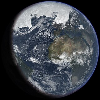
An ice age is a long period of reduction in the temperature of Earth's surface and atmosphere, resulting in the presence or expansion of continental and polar ice sheets and alpine glaciers. Earth's climate alternates between ice ages, and greenhouse periods during which there are no glaciers on the planet. Earth is currently in the ice age called Quaternary glaciation. Individual pulses of cold climate within an ice age are termed glacial periods, and intermittent warm periods within an ice age are called interglacials or interstadials.

Paleoclimatology is the scientific study of climates predating the invention of meteorological instruments, when no direct measurement data were available. As instrumental records only span a tiny part of Earth's history, the reconstruction of ancient climate is important to understand natural variation and the evolution of the current climate.

An ice core is a core sample that is typically removed from an ice sheet or a high mountain glacier. Since the ice forms from the incremental buildup of annual layers of snow, lower layers are older than upper ones, and an ice core contains ice formed over a range of years. Cores are drilled with hand augers or powered drills; they can reach depths of over two miles (3.2 km), and contain ice up to 800,000 years old.

In glaciology, an ice sheet, also known as a continental glacier, is a mass of glacial ice that covers surrounding terrain and is greater than 50,000 km2 (19,000 sq mi). The only current ice sheets are the Antarctic ice sheet and the Greenland ice sheet. Ice sheets are bigger than ice shelves or alpine glaciers. Masses of ice covering less than 50,000 km2 are termed an ice cap. An ice cap will typically feed a series of glaciers around its periphery.
This glossary of climate change is a list of definitions of terms and concepts relevant to climate change, global warming, and related topics.

Marie Byrd Land (MBL) is an unclaimed region of Antarctica. With an area of 1,610,000 km2 (620,000 sq mi), it is the largest unclaimed territory on Earth. It was named after the wife of American naval officer Richard E. Byrd, who explored the region in the early 20th century.
The Cooperative Institute for Research in Environmental Sciences (CIRES) is a research institute that is sponsored jointly by the National Oceanic and Atmospheric Administration (NOAA) Office of Oceanic and Atmospheric Research (OAR) and the University of Colorado Boulder (CU). CIRES scientists study the Earth system, including the atmosphere, hydrosphere, cryosphere, biosphere, and geosphere, and communicate these findings to decision makers, the scientific community, and the public.

Timothy Raymond Naish is a New Zealand glaciologist and climate scientist who has been a researcher and lecturer at Victoria University of Wellington and the Director of the Antarctic Research Centre, and in 2020 became a programme leader at the Antarctic Science Platform. Naish has researched and written about the possible effect of melting ice sheets in Antarctica on global sea levels due to high CO2 emissions causing warming in the Southern Ocean. He was instrumental in establishing and leading the Antarctica Drilling Project (ANDRILL), and a Lead Author on the Intergovernmental Panel on Climate Change (IPCC) 5th Assessment Report (2014).
Throughout Earth's climate history (Paleoclimate) its climate has fluctuated between two primary states: greenhouse and icehouse Earth. Both climate states last for millions of years and should not be confused with glacial and interglacial periods, which occur as alternate phases within an icehouse period and tend to last less than 1 million years. There are five known Icehouse periods in Earth's climate history, which are known as the Huronian, Cryogenian, Andean-Saharan, Late Paleozoic, and Late Cenozoic glaciations. The main factors involved in changes of the paleoclimate are believed to be the concentration of atmospheric carbon dioxide, changes in Earth's orbit, long-term changes in the solar constant, and oceanic and orogenic changes from tectonic plate dynamics. Greenhouse and icehouse periods have played key roles in the evolution of life on Earth by directly and indirectly forcing biotic adaptation and turnover at various spatial scales across time.
The WAIS Divide is the ice flow divide on the West Antarctic Ice Sheet (WAIS) which is a linear boundary that separates the region where the ice flows to the Ross Sea, from the region where the ice flows to the Weddell Sea. It is similar to a continental hydrographic divide.

The East Antarctic Ice Sheet (EAIS) lies between 45° west and 168° east longitudinally. It was first formed around 34 million years ago, and it is the largest ice sheet on the entire planet, with far greater volume than the Greenland ice sheet or the West Antarctic Ice Sheet (WAIS), from which it is separated by the Transantarctic Mountains. The ice sheet is around 2.2 km (1.4 mi) thick on average and is 4,897 m (16,066 ft) at its thickest point. It is also home to the geographic South Pole, South Magnetic Pole and the Amundsen–Scott South Pole Station.
This is a list of climate change topics.

The history of the scientific discovery of climate change began in the early 19th century when ice ages and other natural changes in paleoclimate were first suspected and the natural greenhouse effect was first identified. In the late 19th century, scientists first argued that human emissions of greenhouse gases could change Earth's energy balance and climate. The existence of the greenhouse effect, while not named as such, was proposed as early as 1824 by Joseph Fourier. The argument and the evidence were further strengthened by Claude Pouillet in 1827 and 1838. In 1856 Eunice Newton Foote demonstrated that the warming effect of the sun is greater for air with water vapour than for dry air, and the effect is even greater with carbon dioxide.

Climate change feedbacks are natural processes which impact how much global temperatures will increase for a given amount of greenhouse gas emissions. Positive feedbacks amplify global warming while negative feedbacks diminish it. Feedbacks influence both the amount of greenhouse gases in the atmosphere and the amount of temperature change that happens in response. While emissions are the forcing that causes climate change, feedbacks combine to control climate sensitivity to that forcing.

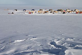
Siple Dome is an ice dome approximately 100 km wide and 100 km long, located 130 km east of Siple Coast in Antarctica. Charles Bentley and Robert Thomas established a "strain rosette" on this feature to determine ice movement in 1973–74. They referred to the feature as Siple Dome because of its proximity to Siple Coast.

Global surface temperature (GST) is the average temperature of Earth's surface. It is determined nowadays by measuring the temperatures over the ocean and land, and then calculating a weighted average. The temperature over the ocean is called the sea surface temperature. The temperature over land is called the surface air temperature. Temperature data comes mainly from weather stations and satellites. To estimate data in the distant past, proxy data can be used for example from tree rings, corals, and ice cores. Observing the rising GST over time is one of the many lines of evidence supporting the scientific consensus on climate change, which is that human activities are causing climate change.
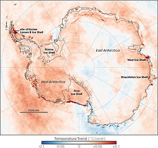
Climate change caused by greenhouse gas emissions from human activities occurs everywhere on Earth, and while Antarctica is less vulnerable to it than any other continent, climate change in Antarctica has already been observed. There has been an average temperature increase of >0.05 °C/decade since 1957 across the continent, although it had been uneven. While West Antarctica warmed by over 0.1 °C/decade from the 1950s to the 2000s and the exposed Antarctic Peninsula has warmed by 3 °C (5.4 °F) since the mid-20th century, the colder and more stable East Antarctica had been experiencing cooling until the 2000s. Around Antarctica, the Southern Ocean has absorbed more heat than any other ocean, with particularly strong warming at depths below 2,000 m (6,600 ft) and around the West Antarctic, which has warmed by 1 °C (1.8 °F) since 1955.
Jérôme Chappellaz is a French glaciologist, geochemist and paleoclimatologist who is director of the French Polar Institute. A senior researcher at France's National Center for Scientific Research (CNRS), he is a co-founder and chairman of the Ice Memory Foundation.

Robert Murray McKay is a paleoceanographer who specialises in sedimentology, stratigraphy and palaeoclimatology, specifically gathering geological evidence to study how marine-based portions of the Antarctic ice sheet behave in response to abrupt climate and oceanic change. He has been involved in examination of marine sedimentary records and glacial deposits to show melting and cooling in Antarctica over the past 65 million years and how this has influenced global sea levels and climate. This has helped climate change scientists overcome uncertainty about how the ice sheets will respond to global warming and how this can be managed effectively in the 21st century. He has participated in international projects including ANDRILL and the International Ocean Discovery Program (IODP), led major New Zealand government-funded research teams and has received several awards in recognition of his work. Since 2023 McKay has been a full professor at Victoria University of Wellington and from 2019, director of the Antarctic Research Centre.
Ice Memory is an international initiative which aims to constitute the first world library of archived glacier ice, to preserve this invaluable scientific heritage for the generations to come, when future techniques can obtain even more data from these samples.
References
- ↑ University of Copenhagen. (2012). Centre for Ice and Climate. Retrieved December 6, 2012 [ dead link ][ permanent dead link ]
- ↑ "National Science Foundation. (2012, December 6). Science. Retrieved December 6, 2012, from WAIS Divide Ice Core website". Archived from the original on 2013-07-05. Retrieved 2013-07-01.
| | This glaciology article is a stub. You can help Wikipedia by expanding it. |
| | This article related to topography is a stub. You can help Wikipedia by expanding it. |