Kame

Last updated
A kame near Kirriemuir, Scotland Kame below Wester Pearsie - geograph.org.uk - 605724.jpg
A kame near Kirriemuir, Scotland
A kame in Yellowstone National Park, Wyoming Dude Hill - Glacial Kame - Yellowstone USA.jpg
A kame in Yellowstone National Park, Wyoming
A kame among the glacial drift on the terminal moraine of the Okanagan Lobe of the Cordilleran Ice Sheet on the Waterville Plateau of the Columbia Plateau in Washington Glacial-Drift-PB110031.JPG
A kame among the glacial drift on the terminal moraine of the Okanagan Lobe of the Cordilleran Ice Sheet on the Waterville Plateau of the Columbia Plateau in Washington

A kame, or knob, is a glacial landform, an irregularly shaped hill or mound composed of sand, gravel and till that accumulates in a depression on a retreating glacier, and is then deposited on the land surface with further melting of the glacier. Kames are often associated with kettles, and this is referred to as kame and kettle or knob and kettle [1] topography. The word kame is a variant of comb (kame, or kaim is the Old Scottish word for comb), which has the meaning "crest" among others. [2] The geological term was introduced by Thomas Jamieson in 1874. [3]

Contents

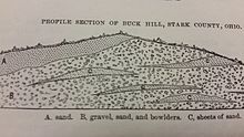
According to White, "kames were formed by meltwater which deposited more or less washed material at irregular places in and along melting ice. At places the material is very well washed and stratified; at others it is more poorly washed, with inclusions of till masses that fell from ice but were covered before they were completely washed. Kame gravels thus tend to be variable and range from fine to coarse grained and even to cobbly and boulder." [4]

With the melting of the glacier, streams carry sediment to glacial lakes, building kame deltas on top of the ice. However, with the continuous melting of the glacier, the kame delta eventually collapses onto the land surface, furthering the "kame and kettle" topography.

Kame terraces are frequently found along the side of a glacial valley and are stratified deposits of meltwater streams flowing between the ice and the adjacent valley side. [4] These kame terraces tend to look like long, flat benches, with many pits on the surface made by kettles. They tend to slope downvalley with gradients similar to the glacier surface along which they formed, and can sometimes be found paired on opposite sides of a valley.

Kames are sometimes compared to drumlins, but their formation is distinctively different. A drumlin is not originally shaped by meltwater, but by the ice itself and has a quite regular shape. It occurs in fine-grained material, such as clay or shale, not in sands and gravels. And drumlins usually have concentric layers of material, as the ice successively plasters new layers in its movement.

Examples

Kame internal structure as sketched by Newberry in 1874 Kame internal structure.jpg
Kame internal structure as sketched by Newberry in 1874

Kames are not normally located in proximity to one another, however in Edmonton, Alberta, numerous kames are found nearby, forming the Prosser Archaeological Site. The Fonthill Kame in southern Ontario is in a densely populated area. Examples can also be found in Wisconsin and at the Sims Corner Eskers and Kames National Natural Landscape in Washington. They are also located in Mendon Ponds Park, southeast of Rochester, New York. This park is on the National Registry of Natural Landmarks due to geological history and presence of significant kames, eskers and kettles.

In Ontario, there are two provincial parks, both designated as IUCN nature reserves, which were created to protect important and undisturbed kame features. They are Minnitaki Kames Provincial Park and Bonheur River Kame Provincial Park.

See also

Related Research Articles

<span class="mw-page-title-main">Glacier</span> Persistent body of ice that is moving under its own weight

A glacier is a persistent body of dense ice that is constantly moving under its own weight. A glacier forms where the accumulation of snow exceeds its ablation over many years, often centuries. It acquires distinguishing features, such as crevasses and seracs, as it slowly flows and deforms under stresses induced by its weight. As it moves, it abrades rock and debris from its substrate to create landforms such as cirques, moraines, or fjords. Although a glacier may flow into a body of water, it forms only on land and is distinct from the much thinner sea ice and lake ice that form on the surface of bodies of water.

<span class="mw-page-title-main">Drumlin</span> Elongated hill formed by glacial action

A drumlin, from the Irish word droimnín, first recorded in 1833, in the classical sense is an elongated hill in the shape of an inverted spoon or half-buried egg formed by glacial ice acting on underlying unconsolidated till or ground moraine. Assemblages of drumlins are referred to as fields or swarms; they can create a landscape which is often described as having a 'basket of eggs topography'.

<span class="mw-page-title-main">Moraine</span> Glacially formed accumulation of debris

A moraine is any accumulation of unconsolidated debris, sometimes referred to as glacial till, that occurs in both currently and formerly glaciated regions, and that has been previously carried along by a glacier or ice sheet. It may consist of partly rounded particles ranging in size from boulders down to gravel and sand, in a groundmass of finely-divided clayey material sometimes called glacial flour. Lateral moraines are those formed at the side of the ice flow, and terminal moraines were formed at the foot, marking the maximum advance of the glacier. Other types of moraine include ground moraines and medial moraines.

<span class="mw-page-title-main">Till</span> Unsorted glacial sediment

Till or glacial till is unsorted glacial sediment.

<span class="mw-page-title-main">Esker</span> Long, winding ridge of stratified sand and gravel associated with former glaciers

An esker, eskar, eschar, or os, sometimes called an asar, osar, or serpent kame, is a long, winding ridge of stratified sand and gravel, examples of which occur in glaciated and formerly glaciated regions of Europe and North America. Eskers are frequently several kilometres long and, because of their uniform shape, look like railway embankments.

<span class="mw-page-title-main">Glaciology</span> Scientific study of ice and natural phenomena involving ice

Glaciology is the scientific study of glaciers, or more generally ice and natural phenomena that involve ice.

A kame delta is a glacial landform formed by a stream of melt water flowing through or around a glacier and depositing material, known as kame deposits. Upon entering a proglacial lake at the end (terminus) of a glacier, the river/stream deposit these sediments. This landform can be observed after the glacier has melted and the delta's asymmetrical triangular shape is visible. Once the glacier melts, the edges of the delta may subside as ice under it melts. Glacial till is deposited on the lateral sides of the delta, as the glacier melts.

<span class="mw-page-title-main">Wisconsin glaciation</span> North American glacial ice sheet

The Wisconsin Glacial Episode, also called the Wisconsin glaciation, was the most recent glacial period of the North American ice sheet complex. This advance included the Cordilleran Ice Sheet, which nucleated in the northern North American Cordillera; the Innuitian ice sheet, which extended across the Canadian Arctic Archipelago; the Greenland ice sheet; and the massive Laurentide Ice Sheet, which covered the high latitudes of central and eastern North America. This advance was synchronous with global glaciation during the last glacial period, including the North American alpine glacier advance, known as the Pinedale glaciation. The Wisconsin glaciation extended from approximately 75,000 to 11,000 years ago, between the Sangamonian Stage and the current interglacial, the Holocene. The maximum ice extent occurred approximately 25,000–21,000 years ago during the last glacial maximum, also known as the Late Wisconsin in North America.

<span class="mw-page-title-main">Kettle (landform)</span> Depression or hole in an outwash plain formed by retreating glaciers or draining floodwaters

A kettle is a depression or hole in an outwash plain formed by retreating glaciers or draining floodwaters. The kettles are formed as a result of blocks of dead ice left behind by retreating glaciers, which become surrounded by sediment deposited by meltwater streams as there is increased friction. The ice becomes buried in the sediment and when the ice melts, a depression is left called a kettle hole, creating a dimpled appearance on the outwash plain. Lakes often fill these kettles; these are called kettle hole lakes. Another source is the sudden drainage of an ice-dammed lake and when the block melts, the hole it leaves behind is a kettle. As the ice melts, ramparts can form around the edge of the kettle hole. The lakes that fill these holes are seldom more than 10 m (33 ft) deep and eventually fill with sediment. In acid conditions, a kettle bog may form but in alkaline conditions, it will be kettle peatland.

<span class="mw-page-title-main">Till plain</span> Plain of glacial till

Till plains are an extensive flat plain of glacial till that forms when a sheet of ice becomes detached from the main body of a glacier and melts in place, depositing the sediments it carried. Ground moraines are formed with melts out of the glacier in irregular heaps, forming rolling hills. Till plains are common in areas such as the Midwestern United States, due to multiple glaciation events that occurred in the Holocene epoch. During this period, the Laurentide Ice Sheet advanced and retreated during the Pleistocene epoch. Till plains formed by the Wisconsin glaciation cover much of the Midwest, including North Dakota, South Dakota, Indiana, Minnesota, Wisconsin, Iowa, Illinois, and northern Ohio.

<span class="mw-page-title-main">Glacial motion</span> Geological phenomenon

Glacial motion is the motion of glaciers, which can be likened to rivers of ice. It has played an important role in sculpting many landscapes. Most lakes in the world occupy basins scoured out by glaciers. Glacial motion can be fast or slow, but is typically around 25 centimetres per day (9.8 in/d).

<span class="mw-page-title-main">Glacial landform</span> Landform created by the action of glaciers

Glacial landforms are landforms created by the action of glaciers. Most of today's glacial landforms were created by the movement of large ice sheets during the Quaternary glaciations. Some areas, like Fennoscandia and the southern Andes, have extensive occurrences of glacial landforms; other areas, such as the Sahara, display rare and very old fossil glacial landforms.

The Oak Ridges Moraine is a geological landform that runs east-west across south central Ontario, Canada. It developed about 12,000 years ago, during the Wisconsin glaciation in North America. A complex ridge of sedimentary material, the moraine is known to have partially developed under water. The Niagara Escarpment played a key role in forming the moraine in that it acted as a dam for glacial meltwater trapped between it and two ice lobes.

<span class="mw-page-title-main">Drift (geology)</span> Material of glacial origin

In geology, drift is a name for all sediment transported by a glacier and deposited directly by or from the ice, or by glacial meltwater. Drift is often subdivided into unstratified drift that forms moraines and stratified drift that accumulates as stratified and sorted sediments in the form of outwash plains, eskers, kames, varves, and so forth. The term drift clay is a synonym for boulder clay. Both are archaic terms for glacial tills with a fine-grained matrix.

<span class="mw-page-title-main">Bow Valley Provincial Park</span> Provincial park in Alberta, Canada

Bow Valley Provincial Park is a provincial park in Alberta, Canada. Established in 1959 in the arch of the Bow River at its confluence with the Kananaskis River, the park is one park of many within the Kananaskis Country park system.

Fluvioglacial landforms are those that result from the associated erosion and deposition of sediments caused by glacial meltwater. These landforms may also be referred to as glaciofluvial in nature. Glaciers contain suspended sediment loads, much of which is initially picked up from the underlying landmass. Landforms are shaped by glacial erosion through processes such as glacial quarrying, abrasion, and meltwater. Glacial meltwater contributes to the erosion of bedrock through both mechanical and chemical processes.

<span class="mw-page-title-main">Geology of New England</span> Overview of the geology of New England

New England is a region in the North Eastern United States consisting of the states Rhode Island, Connecticut, Massachusetts, New Hampshire, Vermont, and Maine. Most of New England consists geologically of volcanic island arcs that accreted onto the eastern edge of the Laurentian Craton in prehistoric times. Much of the bedrock found in New England is heavily metamorphosed due to the numerous mountain building events that occurred in the region. These events culminated in the formation of Pangaea; the coastline as it exists today was created by rifting during the Jurassic and Cretaceous periods. The most recent rock layers are glacial conglomerates.

The glacial series refers to a particular sequence of landforms in Central Europe that were formed during the Pleistocene glaciation beneath the ice sheets, along their margins and on their forelands during each glacial advance.

A meltwater channel is a channel cut into ice, bedrock or unconsolidated deposits by the flow of water derived from the melting of a glacier or ice-sheet. The channel may form on the surface of, within, beneath, along the margins of or downstream from the ice mass. Accordingly it would be referred to as supraglacial, englacial, subglacial, lateral or proglacial.

<span class="mw-page-title-main">Glaciofluvial deposits</span> Sediments/deposits formed from ice sheets or glaciers

Glaciofluvial deposits or Glacio-fluvial sediments consist of boulders, gravel, sand, silt and clay from ice sheets or glaciers. They are transported, sorted and deposited by streams of water. The deposits are formed beside, below or downstream from the ice. They include kames, kame terraces and eskers formed in ice contact and outwash fans and outwash plains below the ice margin. Typically the outwash sediment is carried by fast and turbulent fluvio-glacial meltwater streams, but occasionally it is carried by catastrophic outburst floods. Larger elements such as boulders and gravel are deposited nearer to the ice margin, while finer elements are carried farther, sometimes into lakes or the ocean. The sediments are sorted by fluvial processes. They differ from glacial till, which is moved and deposited by the ice of the glacier, and is unsorted.

References

  1. "Knob And Kettle | Encyclopedia.com".
  2. "kame" . Oxford English Dictionary (Online ed.). Oxford University Press.(Subscription or participating institution membership required.)
  3. Goudie, Andrew, ed. (2004). "Kame by Eric A. Colhoun". Encyclopedia of Geomorphology. Vol. 2. pp. 581–582. ISBN   9780415327381.
  4. 1 2 White, George (1982). Glacial Geology of Northeastern Ohio, Ohio Geological Survey. Columbus: State of Ohio. pp. 18–19.