The Laurentide ice sheet (LIS) was a massive sheet of ice that covered millions of square miles, including most of Canada and a large portion of the Northern United States, multiple times during the Quaternary glaciation epochs, from 2.58 million years ago to the present.[2]
At times, the ice sheet's southern margin included the present-day sites of coastal towns of the Northeastern United States, and cities such as Boston and New York City and Great Lakes coastal cities and towns as far south as Chicago and St. Louis, Missouri, and then followed the present course of the Missouri River up to the northern slopes of the Cypress Hills, beyond which it merged with the Cordilleran Ice Sheet. The ice coverage extended approximately as far south as 38 degrees latitude mid-continent.[3]
Description
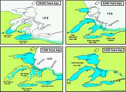
Timeline of glacier retreat in North America
This ice sheet was the primary feature of the Pleistocene epoch in North America, commonly referred to as the ice age. During the Pre-Illinoian Stage, the Laurentide Ice Sheet extended as far south as the Missouri and Ohio River valleys. It was up to 3km (2mi) thick in Nunavik, Quebec, Canada, but much thinner at its edges, where nunataks were common in hilly areas. It created much of the surface geology of southern Canada and the northern United States, leaving behind glacially scoured valleys, moraines, eskers and glacial till. It also caused many changes to the shape, size, and drainage of the Great Lakes. As but one of many examples, near the end of the last ice age, Lake Iroquois extended well beyond the boundaries of present-day Lake Ontario, and drained down the Hudson River into the Atlantic Ocean.[4]
Its cycles of growth and melting were a decisive influence on global climate during its existence. This is because it served to divert the jet stream southward, which would otherwise flow from the relatively warm Pacific Ocean through Montana and Minnesota. That gave the Southwestern United States, otherwise a desert, abundant rainfall during ice ages, in extreme contrast to most other parts of the world which became exceedingly dry, though the effect of ice sheets in Europe had an analogous effect on the rainfall in Afghanistan, parts of Iran, possibly western Pakistan in winter, as well as North Africa.
The Barnes Ice Cap, containing remnants of the Laurentide Ice Sheet.
Its melting also caused major disruptions to the global climate cycle, because the huge influx of low-salinity water into the Arctic Ocean via the Mackenzie River[5] is believed to have disrupted the formation of North Atlantic Deep Water, the very saline, cold, deep water that flows from the Greenland Sea. That interrupted the thermohaline circulation, creating the brief Younger Dryas cold epoch and a temporary re-advance of the ice sheet,[6] which did not retreat from Nunavik until 6,500 years ago.
After the end of the Younger Dryas, the Laurentide Ice Sheet retreated rapidly to the north, becoming limited to only the Canadian Shield until even it became deglaciated.[7] The ultimate collapse of the Laurentide Ice Sheet is also suspected to have influenced European agriculture indirectly through the rise of global sea levels.
During the Late Pleistocene, the Laurentide ice sheet reached from the Rocky Mountains eastward through the Great Lakes, into New England, covering nearly all of Canada east of the Rocky Mountains.[8] Three major ice centers formed in North America: the Labrador, Keewatin, and Cordilleran. The Cordilleran covered the region from the Pacific Ocean to the eastern front of the Rocky Mountains and the Labrador and Keewatin fields are referred to as the Laurentide Ice Sheet. Central North America has evidence of the numerous lobes and sublobes. The Keewatin covered the western interior plains of North America from the Mackenzie River to the Missouri River and the upper reaches of the Mississippi River. The Labrador covered spread over eastern Canada and the northeastern part of the United States abutting the Keewatin lobe in the western Great Lakes and Mississippi valley.[8]
Keewatin ice dome
The Keewatin ice dome has had four or five primary lobes identified ice divides extending from a dome over west-central Keewatin (Kivalliq). Two of the lobes abut the adjacent Labrador and Foxe-Baffin ice domes. The primary lobes flow (1) towards Manitoba and Saskatchewan; (2) toward Hudson Bay; (3) towards the Gulf of Boothia, and (4) towards the Beaufort Sea.[9]
In New York, the ice that covered Manhattan was about 2,000 feet high before it began to melt in about 16,000 BC. The ice in the area disappeared around 10,000 BC. The ground in the New York area has since risen by more than 150ft because of the removal of the enormous weight of the melted ice.[10]
Foxe-Baffin ice dome
The Foxe-Baffin ice dome was circular and centered over the Foxe Basin. A major divide across the basin, created a westward flow across the Melville Peninsula, from an eastward flow over Baffin Island and Southampton Island. Across southern Baffin Island, two divides created four additional lobes. The Penny Ice Divide split the Cumberland Peninsula, where Pangnirtung created flow toward Home Bay on the north and Cumberland Sound on the south. The Amadjuak Ice Divide on the Hall Peninsula, where Iqaluit sits created a north flow into Cumberland Sound and a south flow into the Hudson Strait. A secondary Hall Ice Divide formed a link to a local ice cap on the Hall Peninsula. The current ice caps on Baffin Island are thought to be a remnant from this time period, but it was not a part of the Baffin ice flow, but an autonomous flow.[9]
12Lacelle, D.; Fisher, D. A.; Coulombe, S.; et al. (5 September 2018). "Buried remnants of the Laurentide Ice Sheet and connections to its surface elevation". Scientific Reports 8, 13286 (2018). doi:10.1038/s41598-018-31166-2.
↑"Stratigraphic Chart 2022"(PDF). International Stratigraphic Commission. February 2022. Retrieved 4 June 2022.
↑Dyke, A. S.; Prest, V. K. (1987). "Late Wisconsinan and Holocene History of the Laurentide Ice Sheet". Géographie Physique et Quaternaire. 41 (2): 237–263. doi:10.7202/032681ar.
↑Flint, R.F. 1971. Glacial and Quaternary Geology. Wiley and Sons, NY. p. 892.
1234Geologic Framework and Glaciation of the Central Area, 1 January 2006; Christopher L. Hill; Boise State University, Boise, Idaho; 2006.
1234Late Wisconsinan and Holocene History of the Laurentide Ice Sheet, 10.7202/032681ar; Arthur S. Dyke, Victor K. Prest; Geological Survey of Canada; Ottawa, Ontario; 1987; http://id.erudit.org/iderudit/032681ar.
↑William J. Broad (5 June 2018). "How the Ice Age Shaped New York". The New York Times. Retrieved 24 February 2019. the ice was about 2,000 feet thick over Manhattan
↑Martin Margold; Krister N. Jansson; Johan Kleman; Arjen P. Stroeven; John J. Clague (18 February 2013). "Retreat pattern of the Cordilleran Ice Sheet in central British Columbia at the end of the last glaciation reconstructed from glacial meltwater landforms". Boreas. 42 (4). Wiley Online Library: 830–847. Bibcode:2013Borea..42..830M. doi:10.1111/bor.12007.
This page is based on this Wikipedia article Text is available under the CC BY-SA 4.0 license; additional terms may apply. Images, videos and audio are available under their respective licenses.