Cypress Hills (Canada)

Last updated

Cypress Hills
CypressHills1.JPG
The Cypress Hills
Highest point
Elevation 1,468 m (4,816 ft)
Coordinates 49°37′48″N110°21′34″W / 49.63000°N 110.35944°W / 49.63000; -110.35944
Geography
Canada relief map 2.svg
Red triangle with thick white border.svg
Cypress Hills
Cypress Hills location in Western Canada
CountryCanada
Provinces Alberta and Saskatchewan
Topo map NTS 72E9 Elkwater Lake

The Cypress Hills are a geographical region of hills in southwestern Saskatchewan and southeastern Alberta, Canada. The hills are part of the Missouri Coteau upland.

Contents

The highest point in the Cypress Hills is at Head of the Mountain in Alberta at 1,466 m (4,810 ft). The highest point in Saskatchewan is 1,392 m (4,567 ft), in a farmer's field in the Cypress Hills, at 49°33′N109°59′W / 49.550°N 109.983°W / 49.550; -109.983 . [1] [2]

Name

Cypress Hills Grassland Cypress Hills Grassland.jpg
Cypress Hills Grassland

The Cypress Hills have been known by a wide number of Indigenous and European names throughout their history. An 1882 Blackfoot–English dictionary written by C. M. Lanning provided the Blackfoot language name I-kim-e-kooy, which translates as "striped earth" or "earth over earth". The Cree language name, in use at the same time, is manâtakâw, (spelled in a variety of anglicized forms including "Mun-a-tuh-gow"), sometimes said to mean "beautiful upland" but more accurately referring to "an area to be respected, protected, taken care of and/or taken care with". The Assiniboine language name is wazíȟe. [3] The Gros Ventre language name is θáaciih "pine trees". [4] Early Métis hunters, who spoke Métis French, called the hills les montagnes des Cyprès, in reference to the abundance of Lodgepole Pine trees. In the Canadian French spoken by the Métis, the pine is called cyprès, [5] although it is not a true cypress tree. The English translation is Cypress Hills. [6]

Geology and geomorphology

The Cypress Hills reach a maximum elevation of 1,466 m (4,810 ft), rising about 600 m (2,000 ft) above the surrounding plains. They are the remnant of a more widespread plateau, most of which has been removed by erosion. The plateau is capped by the resistant conglomerate and sandstone beds of the Cypress Hills Formation. That formation was deposited by rivers that flowed from the mountains of southwestern Alberta and northwestern Montana during late Eocene to middle Miocene time, and is known for its wealth of vertebrate fossils. [7] [8]

During the Pleistocene, the top of the Cypress Hills was not overridden by the Laurentide Ice Sheet and remained unglaciated. As the ice sheet paused periodically during its final retreat, a series of morainal ridges of glacial till built up around the hills. Rivers of meltwater cut large channels through the area as the retreat continued, and smaller streams carved coulees and areas of badlands. [9] [10] [11]

Today the Cypress Hills are part of a major drainage divide that separates rivers that drain south to the Gulf of Mexico via the Missouri River system from those that drain to northeast to Hudson Bay via the Nelson River system. [9] At the Dividing Springs Ranch northwest of Eastend, Saskatchewan, the water from a spring goes both south to Gulf of Mexico and northeast to Hudson Bay. [12]

Ecology

The Cypress Hills A panorama of Cypress Hills.jpg
The Cypress Hills

Due to their higher elevation, the upper slopes and summit of the Cypress Hills experience cooler temperatures and greater rainfall than the surrounding semi-arid plains, [13] and they support a flora and fauna that is much like that of the mountains south of the Canada–United States border in Montana and Wyoming. [14]

Flora

The north-facing slopes and some of the valleys host forests of aspen, lodgepole pine, and white spruce. The remainder of the area is covered by mixed grass prairie, with fescue prairie in higher areas. Wildflowers include prairie crocus, three-flowered avens, lupine, blue bells, and prairie rose. [13] [14] [15] There are fourteen species of orchids, including the Venus's slipper orchid and the striped coralroot orchid, which are found primarily in wooded areas and along the banks of springs and streams. [13]

Fauna

Small mammals of the area include a wide variety of rodents, as well as shrews, bats, jackrabbits, skunks, mink, weasels, foxes, bobcats, Canada lynx, and others. Large mammals include moose, elk, mule deer, white-tailed deer, pronghorn, coyotes, cougars, and more. [13] [14] [15] [16] There are several species of snakes, including the prairie rattlesnake, as well as lizards and turtles. The many species of birds range from mountain bluebird and greater sage-grouse to the great horned owl and other birds of prey. [13] [14] [15] Fish in Elkwater Lake and other lakes and streams in the area include walleye, yellow perch, northern pike, several species of trout, and others.

History

Historically the Cypress Hills were a meeting and conflict area for various Native Americans and Indigenous Canadians (First Nations) including the Cree, Assiniboine, Atsina, Blackfoot Confederacy, Saulteaux, Sioux, Crow, and others. During the 19th century Métis settled in the hills, hunting and often wintering there. The Cypress Hills Massacre, a key event in Canadian history leading to the creation of the North-West Mounted Police, occurred in the hills when a group of American wolf hunters, known as wolfers, from Montana massacred an Assiniboine encampment. Fort Walsh was established to bring law and order to the Canada–United States border region.

Interprovincial park

Cypress Hills Provincial Park – one of the six original provincial parks of Saskatchewan – was established in 1931. In 1951, it was extended into neighbouring Alberta. Cypress Hills Interprovincial Park was created in 1989, which joined the two parks on either side of the provincial border. [17]

The Saskatchewan side of the park is divided into two blocks: Centre Block, which has fully developed year round tourist facilities, and West Block Wilderness area, with rustic camping and the location of Fort Walsh National Historic Site. Centre Block is located 30 kilometres (19 mi) south of Maple Creek on Highway 21. West Block is located 45 kilometres (28 mi) southwest of Maple Creek on Highway 271.

The Alberta portion of the Cypress Hills contains the tourist destination of Elkwater, a community with campground facilities located on the southern shore of Elkwater Lake. The townsite is mainly made up of summer cabins. Elkwater is located about 70 kilometres (43 mi) southeast of Medicine Hat.

Climate

Cypress Hills has a subarctic climate (Dfc) bordering on a humid continental climate (Dfb) due to its elevation above the surrounding area. Summer days are mild to warm coupled with cool nights, while winters are cold and snowy with annual snowfall averaging 255.2 cm (100.5 in). It is also considerably more moist than the surrounding prairies. Precipitation peaks during the month of June, where thunderstorms are common. Chinook winds can raise the temperature 5 °C (9.0 °F) in an hour, with it not being uncommon for the temperature to go from −10 to 20 °C (14 to 68 °F) in a 12-hour period. [18] The highest single day snowfall is 60 cm (24 in) which occurred on 28 May 1982. The highest snow depth recorded is 80 cm (31 in) on 28 February 1994. The highest temperature recorded is 40.5 °C (104.9 °F) and occurred on 29 May 1988. The lowest temperature recorded is −42.5 °C (−44.5 °F) and occurred on 13 January 2005. [19]

Climate data for Cypress Hills
Climate ID: 4021996; coordinates 49°40′N109°28′W / 49.667°N 109.467°W / 49.667; -109.467 (Cypress Hills) ; elevation: 1,196 m (3,924 ft); 1981−2010 normals
MonthJanFebMarAprMayJunJulAugSepOctNovDecYear
Record high °C (°F)19.0
(66.2)
18.0
(64.4)
19.0
(66.2)
26.0
(78.8)
40.5
(104.9)
34.0
(93.2)
34.5
(94.1)
34.5
(94.1)
32.0
(89.6)
28.0
(82.4)
21.0
(69.8)
15.0
(59.0)
40.5
(104.9)
Mean daily maximum °C (°F)−3.0
(26.6)
−1.4
(29.5)
2.4
(36.3)
9.8
(49.6)
15.2
(59.4)
19.1
(66.4)
23.2
(73.8)
22.8
(73.0)
16.6
(61.9)
10.1
(50.2)
1.7
(35.1)
−2.3
(27.9)
9.5
(49.1)
Daily mean °C (°F)−9
(16)
−7.2
(19.0)
−2.9
(26.8)
3.5
(38.3)
8.7
(47.7)
12.7
(54.9)
15.9
(60.6)
15.3
(59.5)
9.6
(49.3)
4.0
(39.2)
−3.5
(25.7)
−8.0
(17.6)
3.3
(37.9)
Mean daily minimum °C (°F)−15.0
(5.0)
−13.0
(8.6)
−8.2
(17.2)
−2.9
(26.8)
2.1
(35.8)
6.3
(43.3)
8.6
(47.5)
7.6
(45.7)
2.7
(36.9)
−2.2
(28.0)
−8.6
(16.5)
−13.7
(7.3)
−3.0
(26.6)
Record low °C (°F)−42.5
(−44.5)
−40.0
(−40.0)
−35.5
(−31.9)
−26.5
(−15.7)
−11.5
(11.3)
−3.5
(25.7)
0.0
(32.0)
−4.0
(24.8)
−10.0
(14.0)
−28.5
(−19.3)
−39.0
(−38.2)
−41.5
(−42.7)
−42.5
(−44.5)
Average precipitation mm (inches)33.3
(1.31)
31.0
(1.22)
43.3
(1.70)
41.4
(1.63)
74.0
(2.91)
103.3
(4.07)
59.7
(2.35)
47.8
(1.88)
58.9
(2.32)
36.8
(1.45)
32.8
(1.29)
38.3
(1.51)
600.6
(23.64)
Average rainfall mm (inches)0.0
(0.0)
0.1
(0.00)
1.9
(0.07)
15.9
(0.63)
51.1
(2.01)
103
(4.1)
59.7
(2.35)
46.8
(1.84)
51.1
(2.01)
13.6
(0.54)
1.9
(0.07)
0.2
(0.01)
345.4
(13.60)
Average snowfall cm (inches)33.3
(13.1)
31.0
(12.2)
41.3
(16.3)
25.5
(10.0)
22.8
(9.0)
0.3
(0.1)
0.0
(0.0)
0.9
(0.4)
7.7
(3.0)
23.2
(9.1)
30.9
(12.2)
38.1
(15.0)
255.2
(100.5)
Average precipitation days (≥ 0.2 mm)9.79.610.59.811.514.310.49.89.78.49.511124.3
Average rainy days (≥ 0.2 mm)0.00.10.814.29.514.310.49.78.84.31.10.263.5
Average snowy days (≥ 0.2 cm)9.79.1106.42.80.10.00.11.74.68.910.964.1
Source: Environment and Climate Change Canada [19]

The Cypress Hills region is featured in Saskatchewan-based country singer Colter Wall's 2022 single "Cypress Hills and the Big Country". [20]

See also

Related Research Articles

<span class="mw-page-title-main">Geography of Alberta</span>

Alberta is one of the thirteen provinces and territories of Canada. Located in Western Canada, the province has an area of 661,190 km2 (255,290 sq mi) and is bounded to the south by the United States state of Montana along 49° north for 298 km (185 mi); to the east at 110° west by the province of Saskatchewan for 1,223 km (760 mi); and at 60° north the Northwest Territories for 644 km (400 mi). The southern half of the province borders British Columbia along the Continental Divide of the Americas on the peaks of the Rocky Mountains, while the northern half borders British Columbia along the 120th meridian west. Along with Saskatchewan it is one of only two landlocked provinces or territories.

Elkwater is an unincorporated community at the western edge of the Cypress Hills in southeastern Alberta, Canada, 65 kilometres (40 mi) southeast of Medicine Hat. The main access route is via Alberta Highway 41, which leads south from the Trans-Canada Highway.

<span class="mw-page-title-main">Assiniboine</span> First Nations people native to the northern Great Plains of North America

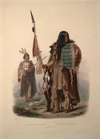
The Assiniboine or Assiniboin people, also known as the Hohe and known by the endonym Nakota, are a First Nations/Native American people originally from the Northern Great Plains of North America.

First Nations in Alberta are a group of people who live in the Canadian province of Alberta. The First Nations are peoples recognized as Indigenous peoples or Plains Indians in Canada excluding the Inuit and the Métis. According to the 2011 Census, a population of 116,670 Albertans self-identified as First Nations. Specifically there were 96,730 First Nations people with registered Indian Status and 19,945 First Nations people without registered Indian Status. Alberta has the third largest First Nations population among the provinces and territories. From this total population, 47.3% of the population lives on an Indian reserve and the other 52.7% live in urban centres. According to the 2011 Census, the First Nations population in Edmonton totalled at 31,780, which is the second highest for any city in Canada. The First Nations population in Calgary, in reference to the 2011 Census, totalled at 17,040. There are 48 First Nations or "bands" in Alberta, belonging to nine different ethnic groups or "tribes" based on their ancestral languages.

<span class="mw-page-title-main">Aspen parkland</span> Temperate grasslands, savannas, and shrublands ecoregion of Canada and the United States

Aspen parkland refers to a very large area of transitional biome between prairie and boreal forest in two sections, namely the Peace River Country of northwestern Alberta crossing the border into British Columbia, and a much larger area stretching from central Alberta, all across central Saskatchewan to south central Manitoba and continuing into small parts of the US states of Minnesota and North Dakota. Aspen parkland consists of groves of aspen, poplar and spruce, interspersed with areas of prairie grasslands, also intersected by large stream and river valleys lined with aspen-spruce forests and dense shrubbery. This is the largest boreal-grassland transition zone in the world and is a zone of constant competition and tension as prairie and woodlands struggle to overtake each other within the parkland.

<span class="mw-page-title-main">Cypress Hills Interprovincial Park</span> Interprovincial park in Western Canada

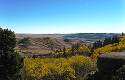
Cypress Hills Interprovincial Park is a natural park in Canada straddling the Alberta / Saskatchewan boundary and jointly administered by the two provinces. Located south-east of Medicine Hat in the Cypress Hills, it became Canada's first interprovincial park in 1989.

<span class="mw-page-title-main">Eastend</span> Town in Saskatchewan

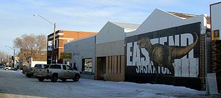
Eastend is a town in south-west part of the Canadian province of Saskatchewan, situated approximately 55 kilometres (34 mi) north of the Montana border and 85 kilometres (53 mi) east of the Alberta border.

<span class="mw-page-title-main">Maple Creek, Saskatchewan</span> Town in Saskatchewan, Canada

Maple Creek is a town in the Cypress Hills of southwest Saskatchewan, Canada. It is surrounded by the Rural Municipality of Maple Creek No. 111. The population was 2,176 at the 2021 Census.

<span class="mw-page-title-main">Scouting and Guiding in Alberta</span>

Scouting and Guiding in Alberta has a long history, from the 1900s to the present day, serving thousands of youth in programs that suit the environment in which they live.

<span class="mw-page-title-main">Cypress County</span> Municipal district in Alberta, Canada

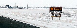
Cypress County is a municipal district in southeastern Alberta, Canada that surrounds the City of Medicine Hat and the Town of Redcliff. The municipality is part of Census Division 1, Alberta. The first farm in the area was settled in 1890.

<span class="mw-page-title-main">Elkwater Lake (Alberta)</span> Lake in Alberta

Elkwater Lake is a small lake located in the northwest corner of the Cypress Hills Interprovincial Park in southeastern Alberta, Canada. It is reached via Alberta Highway 41, and the tourist community of Elkwater lies on its southern shore. Its name is a translation of Ponokiokwe, the Blackfoot name for the lake.

<span class="mw-page-title-main">Southern Alberta</span> Region of Alberta, Canada (est. 1905)

Southern Alberta is a region located in the Canadian province of Alberta. In 2016, the region's population was approximately 291,112. The primary cities are Lethbridge and Medicine Hat. The region is known mostly for agricultural production, but other sectors, such as alternative energy, film production and tourism, are emerging.

<span class="mw-page-title-main">Red Coat Trail</span> Highway in Alberta, Saskatchewan, Manitoba

The Red Coat Trail is a 1,300-kilometre (810 mi) route that approximates the path taken in 1874 by the North-West Mounted Police in their March West from Fort Dufferin to Fort Whoop-Up.

<span class="mw-page-title-main">Edmonton Group</span> Stratigraphic unit in central Alberta, Canada

Within the earth science of geology, the Edmonton Group is a Late Cretaceous to early Paleocene stratigraphic unit of the Western Canada Sedimentary Basin in the central Alberta plains. It was first described as the Edmonton Formation by Joseph Burr Tyrrell in 1887 based on outcrops along the North Saskatchewan River in and near the city of Edmonton. E.J.W. Irish later elevated the formation to group status and it was subdivided into four separate formations. In ascending order, they are the Horseshoe Canyon, Whitemud, Battle and Scollard Formations. The Cretaceous-Paleogene boundary occurs within the Scollard Formation, based on dinosaurian and microfloral evidence, as well as the presence of the terminal Cretaceous iridium anomaly.

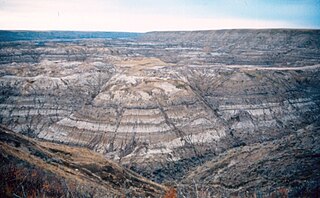
The Cypress Hills Formation is a stratigraphic unit of middle Eocene to early Miocene age in the Western Canada Sedimentary Basin. It is named for the Cypress Hills of southeastern Alberta and southwestern Saskatchewan and was first described from outcrops on the slopes of the Cypress Hills in 1930. It is known for preserving a wealth of vertebrate fossils.

The Palliser Region is an area in the southeast corner of the province of Alberta, Canada that has been delineated and is serviced by the Palliser Economic Partnership. It borders the Canadian province of Saskatchewan to the east, and the US state of Montana to the south. It covers an area of 43,504 km2 (16,797 sq mi) The total population of the area stood at 112,314 in 2009. The city of Medicine Hat, with a population of 61,097, is the area's largest urban centre.

The Iron Confederacy or Iron Confederation was a political and military alliance of Plains Indians of what is now Western Canada and the northern United States. This confederacy included various individual bands that formed political, hunting and military alliances in defense against common enemies. The ethnic groups that made up the Confederacy were the branches of the Cree that moved onto the Great Plains around 1740, the Saulteaux, the Nakoda or Stoney people also called Pwat or Assiniboine, and the Métis and Haudenosaunee. The Confederacy rose to predominance on the northern Plains during the height of the North American fur trade when they operated as middlemen controlling the flow of European goods, particularly guns and ammunition, to other Indigenous nations, and the flow of furs to the Hudson's Bay Company (HBC) and North West Company (NWC) trading posts. Its peoples later also played a major part in the bison (buffalo) hunt, and the pemmican trade. The decline of the fur trade and the collapse of the bison herds sapped the power of the Confederacy after the 1860s, and it could no longer act as a barrier to U.S. and Canadian expansion.

The Whitemud Formation is a geologic formation of Late Cretaceous (Maastrichtian) age in the Western Canada Sedimentary Basin. it is present through the plains of southern Saskatchewan, southeastern Alberta and south-central Alberta. Named by N.B. Davis in 1918, the formation is characterized by white kaolinitic clay and is a source of high-quality refractory clay. The type locality has been designated as Dempster's clay pit northwest of Eastend, Saskatchewan.

References

  1. "Table 15.3 Selected principal heights, by province and territory". Statistics Canada. Retrieved 10 May 2014.
  2. Kerslake, Danny (5 July 2017). "Mystery of Sask.'s nameless highest point solved by podcast". CBC News . Retrieved 5 March 2018.
  3. "AISRI Dictionary Database Search--prototype version. Assiniboine". American Indian Studies Research Institute. Retrieved 7 July 2012.
  4. Cowell, A.; Taylor, A.; Brockie, T. "Gros Ventre ethnogeography and place names: A diachronic perspective". Anthropological Linguistics. 58 (2): 132–170. doi:10.1353/anl.2016.0025.
  5. forêts, Gouvernement du Canada, Ressources naturelles Canada, Service canadien des. "Pin gris". aimfc.rncan.gc.ca.{{cite web}}: CS1 maint: multiple names: authors list (link)
  6. Johnston, Alex (1987). Plants and the Blackfoot. Lethbridge: Lethbridge Historical Society. p. 6. ISBN   978-0919224728.
  7. Leckie, D.A. and Cheel, R.J. 1989. The Cypress Hills Formation – A semi-arid braid plain deposit resulting from intrusive uplift. Canadian Journal of Earth Sciences, vol. 26, p. 1918-1931.
  8. Lerbekmo, J.F. 2000. "Geology of the Alberta Cypress Hills. Edmonton Geological Society, 2000 Fall Field Trip Guide" (PDF). Edmonton Geological Society. Retrieved 5 September 2020.{{cite web}}: CS1 maint: numeric names: authors list (link)
  9. 1 2 Broscoe, A.J. 1965. The geomorphology of the Cypress Hills–Milk River Canyon area, Alberta. Alberta Society of Petroleum Geologists, 15th Annual Field Trip Guidebook, p. 74-84.
  10. Westgate, J.A. 1968. Surficial geology of the Foremost – Cypress Hills area, Alberta. Research Council of Alberta, Bulletin 22.
  11. Rutter, N. 2000. "Notes on the Quaternary geology. Edmonton Geological Society, 2000 Fall Field Trip Guide" (PDF). Edmonton Geological Society. Retrieved 5 September 2020.{{cite web}}: CS1 maint: numeric names: authors list (link)
  12. "Eastend Auto Tour #3" (PDF). Town of Eastend, Saskatchewan. Archived from the original (PDF) on 29 July 2020.
  13. 1 2 3 4 5 Halladay, I.R. 1965. A general survey of the natural history. Alberta Society of Petroleum Geologists, 15th Annual Field Trip Guidebook, Part 1, Cypress Hills plateau, p. 37-54.
  14. 1 2 3 4 McCorquedale, B. 1965. Some particular aspects of the biota of the Cypress Hills. Alberta Society of Petroleum Geologists, 15th Annual Field Trip Guidebook, Part 1, Cypress Hills plateau, p. 55-65.
  15. 1 2 3 Anonymous. "Cypress Hills Provincial Park, Natural Environment". Alberta Parks. Retrieved 7 September 2020.
  16. Saskatchewan Department of Natural Resources, Conservation Information Service (1961). Mammals of Cypress Hills Provincial Park. Regina: Government of Saskatchewan. pp. 4–6.
  17. "Cypress Hills Interprovincial Park" (PDF). Government of Saskatchewan. Archived from the original (PDF) on 13 March 2006.
  18. "Cypress Hills Info". cypresshills.com. Retrieved 8 June 2020.
  19. 1 2 "Cypress Hills". Canadian Climate Normals 1981–2010. Environment Canada. Retrieved 7 April 2020.
  20. Michael Broerman (21 September 2022). "Colter Wall Shares "Cypress Hills and the Big Country" & Cowboy Jack Clement Cover". LiveForLiveMusic.com.

Maple Leaf (from roundel).svg  Canadaportal