Ross Ice Shelf

Last updated • 10 min readFrom Wikipedia, The Free Encyclopedia

Ross Ice Shelf
Corp2401 - Flickr - NOAA Photo Library.jpg
Ross Ice Shelf cliff at the Bay of Whales
Ross Ice Shelf
Coordinates: 81°30′S175°00′W / 81.500°S 175.000°W / -81.500; -175.000
LocationAntarctica
Offshore water bodies Ross Sea
Etymology Sir James Clark Ross, who discovered it on 28 January 1841
Area
  Total500,809 square kilometres (193,363 sq mi)
Dimensions
  Width800 kilometres (500 mi)
Elevation15 and 50 metres (50 and 160 ft)

The Ross Ice Shelf is the largest ice shelf of Antarctica (as of 2013, an area of roughly 500,809 square kilometres (193,363 sq mi) [1] and about 800 kilometres (500 mi) across: about the size of France). [2] It is several hundred metres thick. The nearly vertical ice front to the open sea is more than 600 kilometres (370 mi) long, and between 15 and 50 metres (50 and 160 ft) high above the water surface. [3] Ninety percent of the floating ice, however, is below the water surface.

Contents

Most of the Ross Ice Shelf is in the Ross Dependency claimed by New Zealand. It floats in, and covers, a large southern portion of the Ross Sea and the entire Roosevelt Island located in the east of the Ross Sea.

The ice shelf is named after Sir James Clark Ross, who discovered it on 28 January 1841. It was originally called "The Barrier", with various adjectives including "Great Ice Barrier", as it prevented sailing further south. Ross mapped the ice front eastward to 160° W. In 1947, the U.S. Board on Geographic Names applied the name "Ross Shelf Ice" to this feature and published it in the original U.S. Antarctic Gazetteer. In January 1953, the name was changed to "Ross Ice Shelf"; that name was published in 1956. [4] [5]

Exploration

Crevasse, Ross Ice Shelf in 2001 Ross ice shelf.jpg
Crevasse, Ross Ice Shelf in 2001
Ross Ice Shelf situated between Marie Byrd Land and Victoria Land Map-antarctica-ross-ice-shelf-red-x.png
Ross Ice Shelf situated between Marie Byrd Land and Victoria Land
"The mystic Barrier" at Bay of Whales, near where Amundsen first encountered it.
Note humans for size comparison (dark spots at left between large chunks of sea ice, near the left image border). RV Nathaniel B. Palmer is in the distance. WhalesBayIceShelf.jpg
"The mystic Barrier" at Bay of Whales, near where Amundsen first encountered it.
Note humans for size comparison (dark spots at left between large chunks of sea ice, near the left image border). RV Nathaniel B. Palmer is in the distance.

On 5 January 1841, the British Admiralty's Ross expedition in the Erebus and the Terror , three-masted ships with specially strengthened wooden hulls, was going through the pack ice of the Pacific near Antarctica in an attempt to determine the position of the South Magnetic Pole. Four days later, they found their way into open water and were hoping that they would have a clear passage to their destination. But on 11 January, the men were faced with an enormous mass of ice.

Sir James Clark Ross, the expedition's commander, remarked: "It was an obstruction of such character as to leave no doubt upon my mind as to our future proceedings, for we might with equal chance of success try to sail through the cliffs of Dover". Ross, who in 1831 had located the North Magnetic Pole, spent the next two years vainly searching for a sea passage to the South Pole; later, his name was given to the ice shelf and the sea surrounding it. Two volcanoes in the region were named by Ross for his vessels. [6]

For later Antarctic explorers seeking to reach the South Pole, the Ross Ice Shelf became a starting area. In a first exploration of the area by the Discovery Expedition in 1901–1904, Robert Falcon Scott made a significant study of the shelf and its surroundings from his expedition's base on Ross Island. By measurement of calved ice bergs and their buoyancy, he estimated the ice sheet to be on average 274 meters thick; the undisturbed morphology of the ice sheet and its inverted temperature profile led him to conclude it was floating on water; and measurements in 1902–1903 showed it had advanced 555 meters northwards in 13.5 months. [7] The findings were presented at a lecture entitled "Universitas Antarctica!" given 7 June 1911 and were published in the account of Scott's second expedition (the Terra Nova Expedition of 1910–1913). [8]

Ernest Shackleton's southern party (Shackleton, Adams, Marshal, Wild) of the 1908 Nimrod expedition were the first humans to cross the Ice Shelf during its failed attempt to reach the South Pole. Both Roald Amundsen and Scott crossed the shelf to reach the Pole in 1911. Amundsen wrote: "Along its outer edge the Barrier shows an even, flat surface; but here, inside the bay, the conditions were entirely different. Even from the deck of the Fram we were able to observe great disturbances of the surface in every direction; huge ridges with hollows between them extended on all sides. The greatest elevation lay to the south in the form of a lofty, arched ridge, which we took to be about 500 feet [150 m] high on the horizon. But it might be assumed that this ridge continued to rise beyond the range of vision".

Antarctica (Ross Ice Shelf) taken from orbit by Galileo PIA00074 Antarctica (Ross Ice Shelf).jpg
Antarctica (Ross Ice Shelf) taken from orbit by Galileo

The next day, the party made its first steps on the Barrier. "After half an hour's march we were already at the first important pointthe connection between the sea-ice and the Barrier. This connection had always haunted our brains. What would it be like? A high, perpendicular face of ice, up which we should have to haul our things laboriously with the help of tackles? Or a great and dangerous fissure, which we should not be able to cross without going a long way round? We naturally expected something of the sort. This mighty and terrible monster would, of course, offer resistance in some form or other," he wrote.

"The mystic Barrier! All accounts without exception, from the days of Ross to the present time, had spoken of this remarkable natural formation with apprehensive awe. It was as though one could always read between the lines the same sentence: 'Hush, be quiet! the mystic Barrier!'

"One, two, three, and a little jump, and the Barrier was surmounted!" [9]

Composition and movement

Glacier-ice shelf interactions Glacier-ice shelf interactions.svg
Glacier-ice shelf interactions

Ice shelves are thick plates of ice, formed continuously by glaciers, that float atop an ocean. The shelves act as "brakes" for the glaciers. These shelves serve another important purpose—"they moderate the amount of melting that occurs on the glaciers' surfaces. Once their ice shelves are removed, the glaciers increase in speed due to meltwater percolation and/or a reduction of braking forces, and they may begin to dump more ice into the ocean than they gather as snow in their catchments. Glacier ice speed increases are already observed in Peninsula areas where ice shelves disintegrated in prior years." [10]

The edge of the Ross Ice Shelf in 1997 Ross Ice Shelf 1997.jpg
The edge of the Ross Ice Shelf in 1997
.mw-parser-output .legend{page-break-inside:avoid;break-inside:avoid-column}.mw-parser-output .legend-color{display:inline-block;min-width:1.25em;height:1.25em;line-height:1.25;margin:1px 0;text-align:center;border:1px solid black;background-color:transparent;color:black}.mw-parser-output .legend-text{}
Ross ice shelf in red, other ice shelves in different colors (Filchner-Ronne Ice Shelf in blue for example) Antarctica ice shelves.svg
  Ross ice shelf in red, other ice shelves in different colors (Filchner-Ronne Ice Shelf in blue for example)
Main drill site for the New Zealand 2017 hot water drill camp on the Ross Ice Shelf NZ Ross Ice Shelf Hotwater Tent.jpg
Main drill site for the New Zealand 2017 hot water drill camp on the Ross Ice Shelf

The Ross Ice Shelf is one of many such shelves. It reaches into Antarctica from the north, and covers an area of about 520,000 km2 (200,000 sq mi), nearly the size of France. [2] [3] The ice mass is about 800 km (500 mi) wide and 970 km (600 mi) long. In some places, namely its southern areas, the ice shelf can be almost 750 m (2,450 ft) thick. The Ross Ice Shelf pushes out into the sea at between 1.5 and 3 m (5 and 10 ft) a day. Other glaciers gradually add bulk to it. At the same time, the freezing of seawater below the ice mass increases the thickness of the ice from 40 to 50 cm (16 to 20 in)[ when? ]. Sometimes, fissures and cracks may cause part of the shelf to break off; the largest known is about 31,000 km2 (12,000 sq mi), that is, slightly larger than Belgium. [11] Iceberg B-15, the world's largest recorded iceberg, was calved from the Ross Ice Shelf during March 2000.

Scientists have long been intrigued by the shelf and its composition. Many scientific teams researching the Antarctic have made camps on or adjacent to the Ross Ice Shelf. This includes McMurdo Station, built next to the Ross Ice Shelf on volcanic rock. [12] One major effort was a series of studies conducted in 1957 and 1958, which were continued during the 1960–61 season. The efforts involved an international team of scientists. Some parties explored the glaciers and others the valleys on the ice shelf. [13]

From 1967 to 1972 the Scott Polar Research Institute reported extensive observations using radio echo sounding. The technique allowed measurements to be taken from the air; allowing a criss cross track of 35,000 km to be covered; compared with a 3,000 km track from previous seismic sounding on the ground. [14] More detailed surveys were executed between 1973 and 1978.

A significant scientific endeavor called the Ross Ice Shelf Project was launched with a plan of drilling into the shelf to sample the biomass in the area and make other determinations about the shelf and its relationship to the sea floor. This is believed to be the first oceanographic ice shelf borehole. The project included surface glaciological observations as well as drilling, and the glaciological portion started during the planning phase of the drilling. [15] The drilling portion of the project was to have begun during 1974, but the actual drilling was delayed until 1976. Finally, in 1977, the scientists were able to drill successfully through the ice, making a hole that could be sampled every few days for three weeks. The team was able to map the sea floor, study the tides, and assess the fish and various other forms of life in the waters. The team also examined the oceanographic and geological conditions as well as the temperature of the ice. They estimated that the base of the shelf was −2.16 °C (27.3 °F). They also made other calculations about the fluctuations of the temperatures. [12]

The results of these various projects were published in a series of reports in the 2 February 1979 issue of Science . [12]

During the 1980s, a network of weather stations was installed to record temperatures on the shelf and throughout the more remote parts of the continent. [16]

University of Colorado's National Snow and Ice Data Center has been studying ice shelves and, in 2002, announced that, based on several breakups of ice shelves, including Larsen B, has begun to reassess their stability. Their scientists stated that the temperature of the warmest portion of the shelf is "only a few degrees too cool in summer presently to undergo the same kind of retreat process. The Ross Ice Shelf is the main outlet for several major glaciers draining the West Antarctic Ice Sheet, which contains the equivalent of 5 m of sea level rise in its above-sea-level ice." The report added that observations of "iceberg calving" on the Ross Ice Shelf are, in their opinion, unrelated to its stability. [10]

Scientific exploration continues to uncover interesting information and the analyses have resulted in some interesting theories being posited and publicized. One such opinion, given in 2006 based on a geological survey, suggested that the ice shelf had collapsed previously, perhaps suddenly, which could well happen again. [17]

A science team from New Zealand installed a camp in the centre of the shelf in late 2017. The expedition was led by glaciologist Christina Hulbe [18] and brought together oceanographers, glaciologists, biologists and sedimentologists to examine the ice, ocean and sediment in the central shelf region. One of the key findings was that the ice in the region was re-freezing. [19] This re-freezing and growth of an ice shelf is not uncommon but the Ross Ice Shelf situation appeared to be very variable as there was no evidence of long-term freezing. [20] A recent study attribute this variability in-part to tidal mixing. [21]

A second New Zealand expedition in 2019 traveled to the grounding line region of the Kamb Ice Stream. The hot water drill borehole at this site penetrated through over 500 m of snow and ice to an ocean cavity only 30 m deep at this location. [22] As well as sampling the ocean and sediment, it was the first deployment beneath the Ross Ice Shelf of the Remotely operated underwater vehicle Icefin developed at Georgia Tech, a vehicle designed around parameters suitable for exploration of the liquid cavities of places like Europa. [23] The same New Zealand team returned to another site along the Kamb coast in December 2021, this time drilling through an under-ice river that proved to be essentially oceanic. The team were able to melt through the ice to discover the 250 m deep river had formed a relatively narrow channel beneath the ice. They also recorded evidence of the tsunami generated by the 2022 Hunga Tonga–Hunga Ha'apai eruption and tsunami. [24]

See also

Related Research Articles

<span class="mw-page-title-main">Iceberg</span> Large piece of freshwater ice broken off a glacier or ice shelf and floating in open water

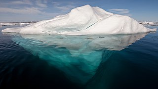
An iceberg is a piece of fresh water ice more than 15 meters long that has broken off a glacier or an ice shelf and is floating freely in open water. Smaller chunks of floating glacially derived ice are called "growlers" or "bergy bits". Much of an iceberg is below the water's surface, which led to the expression "tip of the iceberg" to illustrate a small part of a larger unseen issue. Icebergs are considered a serious maritime hazard.

<span class="mw-page-title-main">Climate of Antarctica</span>

The climate of Antarctica is the coldest on Earth. The continent is also extremely dry, averaging 166 mm (6.5 in) of precipitation per year. Snow rarely melts on most parts of the continent, and, after being compressed, becomes the glacier ice that makes up the ice sheet. Weather fronts rarely penetrate far into the continent, because of the katabatic winds. Most of Antarctica has an ice-cap climate with extremely cold and dry weather.

<span class="mw-page-title-main">Ice shelf</span> Large platform of glacial ice

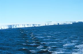
An ice shelf is a large platform of glacial ice floating on the ocean, fed by one or multiple tributary glaciers. Ice shelves form along coastlines where the ice thickness is insufficient to displace the more dense surrounding ocean water. The boundary between the ice shelf (floating) and grounded ice is referred to as the grounding line; the boundary between the ice shelf and the open ocean is the ice front or calving front.

<span class="mw-page-title-main">Amundsen Sea</span> Arm of the Southern Ocean

The Amundsen Sea is an arm of the Southern Ocean off Marie Byrd Land in western Antarctica. It lies between Cape Flying Fish to the east and Cape Dart on Siple Island to the west. Cape Flying Fish marks the boundary between the Amundsen Sea and the Bellingshausen Sea. West of Cape Dart there is no named marginal sea of the Southern Ocean between the Amundsen and Ross Seas. The Norwegian expedition of 1928–1929 under Captain Nils Larsen named the body of water for the Norwegian polar explorer Roald Amundsen while exploring this area in February 1929.

<span class="mw-page-title-main">Larsen Ice Shelf</span> Ice shelf in Antarctica

The Larsen Ice Shelf is a long ice shelf in the northwest part of the Weddell Sea, extending along the east coast of the Antarctic Peninsula from Cape Longing to Smith Peninsula. It is named after Captain Carl Anton Larsen, the master of the Norwegian whaling vessel Jason, who sailed along the ice front as far as 68°10' South during December 1893. In finer detail, the Larsen Ice Shelf is a series of shelves that occupy distinct embayments along the coast. From north to south, the segments are called Larsen A, Larsen B, and Larsen C by researchers who work in the area. Further south, Larsen D and the much smaller Larsen E, F and G are also named.

<span class="mw-page-title-main">McMurdo Sound</span> Geographic location

The McMurdo Sound is a sound in Antarctica, known as the southernmost passable body of water in the world, located approximately 1,300 kilometres (810 mi) from the South Pole.

<span class="mw-page-title-main">Marie Byrd Land</span> Unclaimed West Antarctic region

Marie Byrd Land (MBL) is an unclaimed region of Antarctica. With an area of 1,610,000 km2 (620,000 sq mi), it is the largest unclaimed territory on Earth. It was named after the wife of American naval officer Richard E. Byrd, who explored the region in the early 20th century.

<span class="mw-page-title-main">Bay of Whales</span> Bay

The Bay of Whales was a natural ice harbour, or iceport, indenting the front of the Ross Ice Shelf just north of Roosevelt Island, Antarctica, at the southernmost point of the world's ocean. While the Ross Sea stretches considerably further south – encompassing the Gould Coast, located around 320 kilometres from the South Pole – the majority of this expanse is covered by the Ross Ice Shelf, rather than open sea.

<span class="mw-page-title-main">Leverett Glacier</span> Glacier in Marie Byrd Land, Antarctica

The Leverett Glacier is about 50 nautical miles (90 km) long and 3 to 4 nautical miles wide, flowing from the Antarctic Plateau to the south end of the Ross Ice Shelf through the Queen Maud Mountains. It is an important part of the South Pole Traverse from McMurdo Station to the Admundson–Scott South Pole Station, providing a route for tractors to climb from the ice shelf through the Transantarctic Mountains to the polar plateau.

<span class="mw-page-title-main">Brunt Ice Shelf</span> Antarctic ice shelf

The Brunt Ice Shelf borders the Antarctic coast of Coats Land between Dawson-Lambton Glacier and Stancomb-Wills Glacier Tongue. It was named by the UK Antarctic Place-names Committee after David Brunt, British meteorologist, Physical Secretary of the Royal Society, 1948–57, who was responsible for the initiation of the Royal Society Expedition to this ice shelf in 1955.

<span class="mw-page-title-main">Iceberg B-15</span> Largest recorded iceberg by area

Iceberg B-15 was the largest recorded iceberg by area. It measured around 295 by 37 kilometres, with a surface area of 11,000 square kilometres, about the size of the island of Jamaica. Calved from the Ross Ice Shelf of Antarctica in March 2000, Iceberg B-15 broke up into smaller icebergs, the largest of which was named Iceberg B-15-A. In 2003, B-15A drifted away from Ross Island into the Ross Sea and headed north, eventually breaking up into several smaller icebergs in October 2005. In 2018, a large piece of the original iceberg was steadily moving northward, located between the Falkland Islands and South Georgia Island. As of August 2023, the U.S. National Ice Center (USNIC) still lists one extant piece of B-15 that meets the minimum threshold for tracking. This iceberg, B-15AB, measures 20 km × 7 km ; it is currently grounded off the coast of Antarctica in the western sector of the Amery region.

<span class="mw-page-title-main">Drygalski Ice Tongue</span> Glacier in Antarctica

The Drygalski Ice Tongue, Drygalski Barrier, or Drygalski Glacier Tongue is a glacier in Antarctica, on the Scott Coast, in the northern McMurdo Sound of Ross Dependency, 240 kilometres (150 mi) north of Ross Island. The Drygalski Ice Tongue is stable by the standards of Antarctica's icefloes, and stretches 70 kilometres (43 mi) out to sea from the David Glacier, reaching the sea from a valley in the Prince Albert Mountains of Victoria Land. The Drygalski Ice Tongue ranges from 14 to 24 kilometres wide.

<span class="mw-page-title-main">Amery Ice Shelf</span> Ice shelf in Antarctica

The Amery Ice Shelf is a broad ice shelf in Antarctica at the head of Prydz Bay between the Lars Christensen Coast and Ingrid Christensen Coast. It is part of Mac. Robertson Land. The name "Cape Amery" was applied to a coastal angle mapped on 11 February 1931 by the British Australian New Zealand Antarctic Research Expedition (BANZARE) under Douglas Mawson. He named it for William Bankes Amery, a civil servant who represented the United Kingdom government in Australia (1925–28). The Advisory Committee on Antarctic Names interpreted this feature to be a portion of an ice shelf and, in 1947, applied the name Amery to the whole shelf.

<span class="mw-page-title-main">Mertz Glacier</span> Glacier of Antarctica

Mertz Glacier is a heavily crevassed glacier in George V Coast of East Antarctica. It is the source of a glacial prominence that historically has extended northward into the Southern Ocean, the Mertz Glacial Tongue. It is named in honor of the Swiss explorer Xavier Mertz.

<span class="mw-page-title-main">Pine Island Glacier</span> Large ice stream, fastest melting glacier in Antarctica

Pine Island Glacier (PIG) is a large ice stream, and the fastest melting glacier in Antarctica, responsible for about 25% of Antarctica's ice loss. The glacier ice streams flow west-northwest along the south side of the Hudson Mountains into Pine Island Bay, Amundsen Sea, Antarctica. It was mapped by the United States Geological Survey (USGS) from surveys and United States Navy (USN) air photos, 1960–66, and named by the Advisory Committee on Antarctic Names (US-ACAN) in association with Pine Island Bay.

<span class="mw-page-title-main">Thwaites Glacier</span> Antarctic glacier

Thwaites Glacier is an unusually broad and vast Antarctic glacier located east of Mount Murphy, on the Walgreen Coast of Marie Byrd Land. It was initially sighted by polar researchers in 1940, mapped in 1959–1966 and officially named in 1967, after the late American glaciologist Fredrik T. Thwaites. The glacier flows into Pine Island Bay, part of the Amundsen Sea, at surface speeds which exceed 2 kilometres (1.2 mi) per year near its grounding line. Its fastest-flowing grounded ice is centered between 50 and 100 kilometres east of Mount Murphy. Like many other parts of the cryosphere, it has been adversely affected by climate change, and provides one of the more notable examples of the retreat of glaciers since 1850.

<span class="mw-page-title-main">Totten Glacier</span> Glacier in Antarctica

Totten Glacier is a large glacier draining a major portion of the East Antarctic Ice Sheet, through the Budd Coast of Wilkes Land in the Australian Antarctic Territory. The catchment drained by the glacier is estimated at 538,000 km2 (208,000 sq mi), extending approximately 1,100 km (680 mi) into the interior and holds the potential to raise sea level by at least 3.5 m (11 ft). Totten drains northeastward from the continental ice but turns northwestward at the coast where it terminates in a prominent tongue close east of Cape Waldron. It was first delineated from aerial photographs taken by USN Operation Highjump (1946–47), and named by Advisory Committee on Antarctic Names (US-ACAN) for George M. Totten, midshipman on USS Vincennes of the United States Exploring Expedition (1838–42), who assisted Lieutenant Charles Wilkes with correction of the survey data obtained by the expedition.

<span class="mw-page-title-main">Erebus Glacier Tongue</span> Glacier tongue in Antarctica

The Erebus Glacier Tongue is a mountain outlet glacier and the seaward extension of Erebus Glacier from Ross Island. It projects 11 kilometres (6.8 mi) into McMurdo Sound from the Ross Island coastline near Cape Evans, Antarctica. The glacier tongue varies in thickness from 50 metres (160 ft) at the snout to 300 metres (980 ft) at the point where it is grounded on the shoreline. Explorers from Robert F. Scott's Discovery Expedition (1901–1904) named and charted the glacier tongue.

<span class="mw-page-title-main">Liu Yan (scientist)</span> Chinese Antarctic researcher

Liu Yan is a Chinese Antarctic researcher best known for her work on iceberg calving. She is an associate professor of geography in the College of Global Change and Earth System Science (GCESS) and Polar Research Institute, Beijing Normal University.

<span class="mw-page-title-main">Christina Hulbe</span> American Antarctic researcher, educator

Christina Hulbe is an American Antarctic researcher, and as of 2016 serves as professor and Dean of Surveying at the University of Otago in New Zealand. She was previously Chair of the Geology Department at Portland State University in Portland, Oregon. She leads the NZARI project to drill through the Ross Ice Shelf and is the namesake of the Hulbe glacier.

References

  1. Rignot, E.; Jacobs, S.; Mouginot, J.; Scheuchl, B. (19 July 2013). "Ice-Shelf Melting Around Antarctica". Science. 341 (6143): 266–270. Bibcode:2013Sci...341..266R. doi: 10.1126/science.1235798 . ISSN   0036-8075. PMID   23765278. S2CID   206548095.
  2. 1 2 "Antarctic Hazards". British Antarctic Survey . Retrieved 20 April 2019.
  3. 1 2 Scheffel, Richard L.; Wernet, Susan J., eds. (1980). Natural Wonders of the World. United States of America: Reader's Digest Association, Inc. p. 325. ISBN   978-0-89577-087-5.
  4. 1) [Bertrand, Kenneth John, et al, ed.] The Geographical Names of Antarctica. Special Publication No. 86. Washington, D.C.: U.S. Board on Geographical Names, May 1947. 2) [Bertrand, Kenneth J. and Fred G. Alberts]. Gazetteer No. 14. Geographic Names of Antarctica. Washington: US Government Printing Office, January 1956.
  5. "Ross Ice Shelf Case Brief". US Board on Geographic Names. Retrieved 1 May 2016.
  6. "About – British Antarctic Survey". bas.ac.uk. Retrieved 20 April 2019.
  7. R.F. Scott (1905) The Voyage of the Discovery. Vol II, pp. 411–421 [411] Smith, Elder and Co, London
  8. Scott, Robert and Leonard Huxley. Scott's Last Expedition in Two Volumes: Vol. II. New York: Dodd, Mead and Company, 1913.
  9. Amundsen, Roald. The South Pole An Account of the Norwegian Antarctic Expedition in the 'Fram,' 1910–1912 . Retrieved 1 July 2015. (Translated from the Norwegian by A. G. Chater)
  10. 1 2 "Larsen B Ice Shelf Collapses in Antarctica – National Snow and Ice Data Center". nsidc.org. Retrieved 20 April 2019.
  11. "Antarctica shed a 208-mile-long berg in 1956". usatoday30.usatoday.com. Archived from the original on 28 September 2019. Retrieved 20 April 2019.
  12. 1 2 3 Clough, John W.; Hansen, B. Lyle (2 February 1979), "The Ross Ice Shelf Project", Science, 203 (4379): 433–455, Bibcode:1979Sci...203..433C, doi:10.1126/science.203.4379.433, PMID   17734133, S2CID   28745122.
  13. Swithinbank, Charles (March 1964), "To the Valley Glaciers That Feed the Ross Ice Shelf", The Geographical Journal , 130 (1): 32–48, doi:10.2307/1794263, JSTOR   1794263
  14. Nature-Times News Service; Science report Glaciology: Ross ice shelf flow; The Times ; 28 January 1975; p. 12
  15. Thomas, R.H.; MacAyeal, D.R.; Eilers, D.H.; Gaylord, D.R. (1990), "Glaciological studies on the Ross Ice Shelf, Antarctica, 1973–1978", in Bentley, C. R.; Hayes, D.E. (eds.), The Ross Ice Shelf: Glaciology and Geophysics, Ant. Res. Ser., vol. 42, Washington D.C.: AGU, pp. 21–53, doi:10.1029/AR042p0021, ISBN   978-0-87590-195-4, ISSN   0066-4634.
  16. Patel, Samir S. (5 April 2006). "A Sinking Feeling". Nature. 440 (7085): 734–736. doi: 10.1038/440734a . PMID   16598226. S2CID   1174790.
  17. "Massive ice shelf 'may collapse without warning'". The New Zealand Herald. 29 November 2006.
  18. Morton, Jamie (25 June 2017). "NZ scientists in ambitious project to probe Spain-sized ice shelf" . Retrieved 20 April 2019 via nzherald.co.nz.
  19. "Deep Bore Into Antarctica Finds Freezing Ice, Not Melting as Expected". National Geographic News. 16 February 2018. Archived from the original on 17 February 2018. Retrieved 20 April 2019.
  20. Hulbe, Christina; Stevens, Craig. "Climate scientists explore hidden ocean beneath Antarctica's largest ice shelf". The Conversation. Retrieved 20 April 2019.
  21. Stevens, C., Hulbe, C., Brewer, M., Stewart, C., Robinson, N., Ohneiser, C. and Jendersie, S., 2020. Ocean mixing and heat transport processes observed under the Ross Ice Shelf control its basal melting. Proceedings of the National Academy of Sciences, 117(29), pp. 16799–16804. https://doi.org/10.1073/pnas.1910760117
  22. "Antarctic Update". Radio New Zealand . 3 February 2020.
  23. Schmidt, B.E., Lawrence, J.D., Meister, M.R., Dicheck, D.J.G., Hurwitz, B.C., Spears, A., Mullen, A.D., Washam, P.M., Bryson, F.E., Quartini, E. and Ramey, C.D., 2020. Europa in Our Backyard: Under Ice Robotic Exploration of Antarctic Analogs. LPI, (2326), p. 1065.
  24. Horgan, H. and Stevens C. (2022) Exploring Antarctica's hidden under-ice rivers and their role in future sea-level rise, The Conversation, https://theconversation.com/exploring-antarcticas-hidden-under-ice-rivers-and-their-role-in-future-sea-level-rise-176456