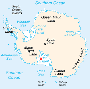
The Ross Sea is a deep bay of the Southern Ocean in Antarctica, between Victoria Land and Marie Byrd Land and within the Ross Embayment, and is the southernmost sea on Earth. It derives its name from the British explorer James Clark Ross who visited this area in 1841. To the west of the sea lies Ross Island and Victoria Land, to the east Roosevelt Island and Edward VII Peninsula in Marie Byrd Land, while the southernmost part is covered by the Ross Ice Shelf, and is about 200 miles (320 km) from the South Pole. Its boundaries and area have been defined by the New Zealand National Institute of Water and Atmospheric Research as having an area of 637,000 square kilometres (246,000 sq mi).

Framheim was the name of explorer Roald Amundsen's base at the Bay of Whales on the Ross Ice Shelf in Antarctica during his successful quest for the South Pole. It was used between January 1911 and February 1912.
Little America was a series of Antarctic exploration bases from 1929 to 1958, located on the Ross Ice Shelf, south of the Bay of Whales.

Marie Byrd Land (MBL) is an unclaimed region of Antarctica. With an area of 1,610,000 km2 (620,000 sq mi), it is the largest unclaimed territory on Earth. It was named after the wife of American naval officer Richard E. Byrd, who explored the region in the early 20th century.

The Brunt Ice Shelf borders the Antarctic coast of Coats Land between Dawson-Lambton Glacier and Stancomb-Wills Glacier Tongue. It was named by the UK Antarctic Place-names Committee after David Brunt, British meteorologist, Physical Secretary of the Royal Society, 1948–57, who was responsible for the initiation of the Royal Society Expedition to this ice shelf in 1955.

Iceberg B-15 was the largest recorded iceberg by area. It measured around 295 by 37 kilometres, with a surface area of 11,000 square kilometres, about the size of the island of Jamaica. Calved from the Ross Ice Shelf of Antarctica in March 2000, Iceberg B-15 broke up into smaller icebergs, the largest of which was named Iceberg B-15-A. In 2003, B-15A drifted away from Ross Island into the Ross Sea and headed north, eventually breaking up into several smaller icebergs in October 2005. In 2018, a large piece of the original iceberg was steadily moving northward, located between the Falkland Islands and South Georgia Island. As of December 2022, the U.S. National Ice Center (USNIC) still lists one extant piece of B-15 that meets the minimum threshold for tracking. This iceberg, B-15ab, measures 20 km × 7 km ; it is currently grounded off the coast of Antarctica in the western sector of the Amery region.

The Amery Ice Shelf is a broad ice shelf in Antarctica at the head of Prydz Bay between the Lars Christensen Coast and Ingrid Christensen Coast. It is part of Mac. Robertson Land. The name "Cape Amery" was applied to a coastal angle mapped on 11 February 1931 by the British Australian New Zealand Antarctic Research Expedition (BANZARE) under Douglas Mawson. He named it for William Bankes Amery, a civil servant who represented the United Kingdom government in Australia (1925–28). The Advisory Committee on Antarctic Names interpreted this feature to be a portion of an ice shelf and, in 1947, applied the name Amery to the whole shelf.

Mertz Glacier is a heavily crevassed glacier in George V Coast of East Antarctica. It is the source of a glacial prominence that historically has extended northward into the Southern Ocean, the Mertz Glacial Tongue. It is named in honor of the Swiss explorer Xavier Mertz.

Sulzberger Bay is a bay between Fisher Island and Vollmer Island, along the coast of King Edward VII Land. Discovered by the Byrd Antarctic Expedition on December 5, 1929, and named by Byrd for Arthur H. Sulzberger, publisher of The New York Times, a supporter of the Byrd expeditions in 1928–1930 and 1933–1935.

Multiple governments have set up permanent research stations in Antarctica and these bases are widely distributed. Unlike the drifting ice stations set up in the Arctic, the research stations of the Antarctic are constructed either on rocks or on ice that are fixed in places.

The Scott Glacier is a major glacier, 120 miles (190 km) long, that drains the East Antarctic Ice Sheet through the Queen Maud Mountains to the Ross Ice Shelf. The Scott Glacier is one of a series of major glaciers flowing across the Transantarctic Mountains, with the Amundsen Glacier to the west and the Leverett and Reedy glaciers to the east.

An iceport is a more-or-less permanent indentation in the front of an ice shelf, that can serve as a natural ice harbour. Though useful, they are not always reliable, as calving of surrounding ice shelves can render an iceport temporarily unstable and unusable.
Erskine Iceport, also known as Erskine Bay or General Erskine Bay, is an iceport about 3 nautical miles (6 km) wide and 6 nautical miles (11 km) long, which marks a more-or-less permanent indentation extending southeast into the seaward front of the extensive ice shelf fringing Queen Maud Land.
Norsel Iceport, also known as Norselbukta or Bukhta Nursel, is a small iceport in the front of the Quar Ice Shelf, along the coast of Queen Maud Land.
Godel Iceport is an iceport about 5 nautical miles (9 km) wide, which marks a more-or-less permanent indentation in the seaward front of the extensive ice shelf fringing the coast of Queen Maud Land.
Glade Bay is an open triangular-shaped bay in the Amundsen Sea, 56 kilometres (30 nmi) wide at the broad north entrance and defined by the angle formed by the northern part of Wright Island, the front of the Getz Ice Shelf, and the northwest side of Murray Foreland, Martin Peninsula, on the Bakutis Coast of Marie Byrd Land, Antarctica. It was mapped by the United States Geological Survey from surveys and U.S. Navy aerial photographs, 1959–67, and was named by the Advisory Committee on Antarctic Names after Commander Gerald L. Glade, U.S. Navy, a helicopter pilot in USS Atka on U.S. Navy Operation Deep Freeze, 1956–57, and Deputy Commander, Naval Support Force, Antarctica, 1975–76.