
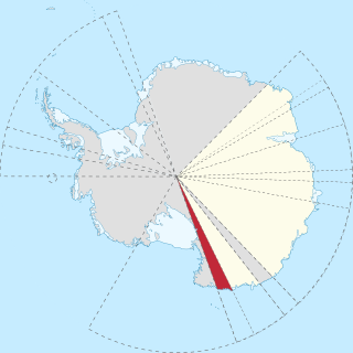
Marie Byrd Land (MBL) is an unclaimed region of Antarctica. With an area of 1,610,000 km2 (620,000 sq mi), it is the largest unclaimed territory on Earth. It was named after the wife of American naval officer Richard E. Byrd, who explored the region in the early 20th century.
The Greenwell Glacier is a major tributary glacier, 45 nautical miles long, draining northwest between the Mirabito Range and the Everett Range to enter Lillie Glacier below Mount Works, in northwest Victoria Land, Antarctica. This geographical feature was first mapped by the United States Geological Survey from surveys and from U.S. Navy aerial photography, 1960–63, and was so named by the Advisory Committee on Antarctic Names for Commander Martin D. Greenwell, U.S. Navy, Commander of Antarctic Squadron Six (VX-6), 1961–62. The glacier lies situated on the Pennell Coast, a portion of Antarctica lying between Cape Williams and Cape Adare.
Foundation Ice Stream is a major ice stream in Antarctica's Pensacola Mountains. The ice stream drains northward for 150 nautical miles along the west side of the Patuxent Range and the Neptune Range to enter the Ronne Ice Shelf westward of Dufek Massif. The United States Geological Survey mapped the stream from surveys and U.S. Navy air photos, 1956–66. The Advisory Committee on Antarctic Names named the stream in recognition of the National Science Foundation, which provided major support to the U.S. Antarctic Research Program during this period.
Eights Coast is that portion of the coast of West Antarctica between Cape Waite and Pfrogner Point. To the west is the Walgreen Coast, and to the east is the Bryan Coast. It is part of Ellsworth Land and stretches between 103°24'W and 89°35'W. This coast is bordered by Thurston Island, Abbot Ice Shelf and some islands within the ice shelf, and for most of its length touches the Bellingshausen Sea. Most of Eights Coast is not claimed by any nation. In the east, Eights Coast borders the sector claimed by Chile as part of its southernmost province. Peter I Island, 450 km north of the coast, is claimed by Norway as a dependency.
Siple Coast is the middle portion of the relatively ill-defined coast along the east side of the Ross Ice Shelf, between the north end of Gould Coast and the south end of Shirase Coast. The area was originally called Kirton Coast, but was renamed by NZ-APC in 1961 after Paul A. Siple, a noted American scientist-explorer who accompanied R. Admiral Richard E. Byrd on all of his Antarctic expeditions.
Oates Land is a region of Antarctica. It is variously defined as a portion of the East Antarctica near the coast stretching along and inland from the Oates Coast and as an officially delineated wedge-shaped segment of the Australian Antarctic Territory. The segment of the Australian claim extends between 153°45' E and 160° E, forming a wedge between Latitude 60° S and the South Pole. It is bounded in the east by the Ross Dependency and overlaps George V Land to the west.
Engelhardt Ice Ridge is an ice ridge between Whillans Ice Stream and Kamb Ice Stream near the junction of Gould Coast and Siple Coast in Marie Byrd Land, Antarctica. It was named by the Advisory Committee on Antarctic Names after Hermann Engelhardt of the Division of Geological and Planetary Sciences, California Institute of Technology; he was a United States Antarctic Program geophysicist who drilled boreholes in Whillans and Kamb Ice Streams in four field seasons, 1991–96.
Mercer Ice Stream, formerly Ice Stream A, flows west to Gould Coast to the south of Whillans Ice Stream, Antarctica. It is the southernmost of several major ice streams draining from Marie Byrd Land into the Ross Ice Shelf. The ice streams were investigated and mapped by U.S. Antarctic Research Program personnel in a number of field seasons from 1983–84 and named Ice Stream A, B, C, etc., according to their position from south to north. The name was changed by the Advisory Committee on Antarctic Names in 2002 to honor Quaternary geologist John H. Mercer (1922–87) of the Institute of Polar Studies, Ohio State University, who mapped the moraines above Reedy Glacier and in the Ohio Range at the head of Horlick Ice Stream, the major tributaries to Mercer Ice Stream.
The Anderson Hills are an irregular group of hills, ridges and peaks between Mackin Table and the Thomas Hills in the Patuxent Range, Pensacola Mountains, Antarctica. They were mapped by the United States Geological Survey from surveys and from U.S. Navy air photos, 1956–66. The hills were named by the Advisory Committee on Antarctic Names at the suggestion of Captain Finn Ronne, U.S. Navy Reserve, leader at Ellsworth Station, 1957. As Deputy Secretary of Defense, 1954–55, Robert B. Anderson had responsibilities for U.S. operations in Antarctica.
Beascochea Bay is a bay, 10 nautical miles (19 km) long and 5 nautical miles (9 km) wide, indenting the Graham Coast of Graham Land, Antarctica, between Kyiv Peninsula and Barison Peninsula, and entered south of Cape Perez. The glaciers Lever, Funk, Cadman, Talev and Butamya feed the bay.

The Dufek Coast is that portion of the coast along the southwest margin of the Ross Ice Shelf between Airdrop Peak on the east side of the Beardmore Glacier and Morris Peak on the east side of Liv Glacier. It was named by the New Zealand Antarctic Place-Names Committee in 1961 after Rear Admiral George J. Dufek, United States Navy, who served under Rear Admiral Richard E. Byrd with the United States Antarctic Service, 1939–41, and as commander of the Eastern Task Force of U.S. Navy Operation Highjump, 1946–47. He was Commander of U.S. Naval Support Force Antarctica, 1954–59, a period in which the following American science stations were established: McMurdo Station, Little America V, Byrd Station, South Pole Station, Wilkes Station, Hallett Station and Ellsworth Station. United States Navy ships, aircraft, and personnel under his command provided broad logistical support to research and survey operations, including aerial photographic missions to virtually all sectors of Antarctica. On October 31, 1956, Dufek in the ski-equipped R4D Skytrain aircraft Que Sera Sera, flew from McMurdo Sound via Beardmore Glacier to make the first airplane landing at the South Pole.
Fendorf Glacier is a broad glacier draining from the eastern slopes of the Gifford Peaks and flowing north to merge with Dobbratz Glacier, in the Heritage Range of the Ellsworth Mountains, Antarctica. It was mapped by the United States Geological Survey from ground surveys and U.S. Navy air photos, 1961–66, and was named by the Advisory Committee on Antarctic Names for Lieutenant Commander James E. Fendorf, U.S. Navy, a pilot with Squadron VX-6 during Operation Deep Freeze 1966.
Lliboutry Glacier is a glacier flowing southwest from the Boyle Mountains of Antarctica into Bourgeois Fjord, Loubet Coast. It was named by the UK Antarctic Place-Names Committee in 1983 after Louis A.F. Lliboutry, a French physicist and glaciologist who investigated the mechanical deformation of ice and the micro-meteorological properties of ice surfaces, and who also made a general study of glaciers in the Antarctic Peninsula. Lliboutry was Director of the Laboratory of Glaciology, University of Grenoble, 1958–83, and President of the International Commission on Snow and Ice, 1983–87.

Hudman Glacier is a glacier draining south of Mount Landolt between Marze Peak and Miller Peak in Petvar Heights at the south end of the Sentinel Range, in the Ellsworth Mountains of Antarctica, flowing south-southeast to Minnesota Glacier. It was mapped by the United States Geological Survey from surveys and U.S. Navy air photos, 1957–59, and was named by the Advisory Committee on Antarctic Names for Captain Rayburn A. Hudman, United States Marine Corps, who died in the crash of a Lockheed P2V-2n Neptune, modified for extreme range, flying in sub zero temperatures and Ski equippedfor landing on the Ice runways at McMurdo Sound Antarctica on October 18, 1956.
Marze Peak is a rock peak with twin summits near the south end of the ridge between Wessbecher Glacier and Hudman Glacier, in the Petvar Heights at the south end of the Sentinel Range, Ellsworth Mountains, Antarctica. It was mapped by the United States Geological Survey from surveys and U.S. Navy air photos from 1957 to 1959, and was named by the Advisory Committee on Antarctic Names for Marion O. Marze, an aviation machinist's mate from the U.S. Navy who perished in the crash of a P2V Neptune airplane at McMurdo Sound on October 18, 1956.

Hlubeck Glacier is a glacier 9 nautical miles west of Long Glacier in southeast Thurston Island, Antarctica. It flows south along the east side of Shelton Head into the Abbot Ice Shelf. The glacier was named by the Advisory Committee on Antarctic Names after aviation radioman Vernon R. Hlubeck, a PBM Mariner aircrewman in the Eastern group of U.S. Navy Operation Highjump, which obtained aerial photographs of Thurston Island and adjoining coastal areas, 1946–47.
The Hess Mountains are a group of mountains rising to about 1,500 metres (5,000 ft) at the head of Hilton Inlet on the Black Coast of Antarctica, to the west of Dietz Bluff and bounded to the north by Gruening Glacier, to the west by Runcorn Glacier and to the south by Beaumont Glacier. The mountains were first photographed from the air by the United States Antarctic Service, 1940, and were mapped by the United States Geological Survey from aerial photographs taken by the U.S. Navy, 1966–69. They were surveyed by the British Antarctic Survey, 1972–73, and, in association with the names of continental drift scientists grouped in this area, named by the Advisory Committee on Antarctic Names, 1978, after the American Harry H. Hess, Professor of Geology at Princeton University, 1948–69.
Kirkpatrick Glacier is a tributary glacier about 12 nautical miles (22 km) long, flowing west along the south side of the McDonald Heights to enter the east side of Hull Glacier near the coast of Marie Byrd Land, Antarctica. It was mapped by the United States Geological Survey from surveys and U.S. Navy air photos, 1959–65, and was named by the Advisory Committee on Antarctic Names for Commander Thomas W. Kirkpatrick, United States Coast Guard, Ship Operations Officer, U.S. Naval Support Force, Antarctica, during Operation Deep Freeze 1972 and 1973.
Holzrichter Glacier is a broad tributary glacier which drains the northeastern slopes of the Prince Olav Mountains of Antarctica between Mount Wade and Mount Oliver and enters Gough Glacier just north of Mount Dodge. It was named by the Advisory Committee on Antarctic Names for Captain Max A. Holzrichter, U.S. Navy, Deputy Commander and Chief of Staff of the U.S. Naval Support Force, Antarctica in 1964 and 1965.
Mount Landolt is a mountain, 2,280 metres (7,480 ft) high, standing at the head of Hudman Glacier in the Petvar Heights at the southeastern extremity of the Sentinel Range in the Ellsworth Mountains of Antarctica. It was first mapped by the United States Geological Survey from surveys and U.S. Navy air photos from 1957 to 1959, and was named by the Advisory Committee on Antarctic Names for Arlo U. Landolt, an aurora scientist at the International Geophysical Year South Pole Station in 1957.
