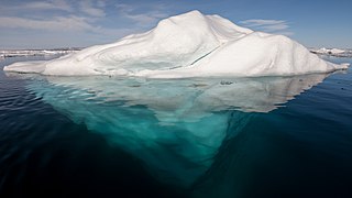
An iceberg is a large piece of freshwater ice that has broken off a glacier or an ice shelf and is floating freely in open (salt) water. Small bits of disintegrating icebergs are called "growlers" or "bergy bits".

The Beardmore Glacier in Antarctica is one of the largest valley glaciers in the world, being 200 km (125 mi) long and having a width of 40 km (25 mi). It descends about 2,200 m (7,200 ft) from the Antarctic Plateau to the Ross Ice Shelf and is bordered by the Commonwealth Range of the Queen Maud Mountains on the eastern side and the Queen Alexandra Range of the Central Transantarctic Mountains on the western.
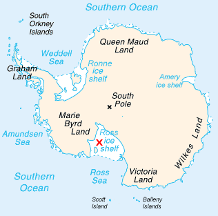
The Ross Ice Shelf is the largest ice shelf of Antarctica. It is several hundred metres thick. The nearly vertical ice front to the open sea is more than 600 kilometres (370 mi) long, and between 15 and 50 metres high above the water surface. Ninety percent of the floating ice, however, is below the water surface.

The Filchner-Ronne Ice Shelf, also known as Ronne-Filchner Ice Shelf, is an Antarctic ice shelf bordering the Weddell Sea.
The Transantarctic Mountains comprise a mountain range of uplifted rock in Antarctica which extend, with some interruptions, across the continent from Cape Adare in northern Victoria Land to Coats Land. These mountains divide East Antarctica and West Antarctica. They include a number of separately named mountain groups, which are often again subdivided into smaller ranges.

The Axel Heiberg Glacier in Antarctica is a valley glacier, 30 nmi (35 mi) long, descending from the high elevations of the Antarctic Plateau into the Ross Ice Shelf between the Herbert Range and Mount Don Pedro Christophersen in the Queen Maud Mountains.

Marie Byrd Land is the portion of West Antarctica lying east of the Ross Ice Shelf and the Ross Sea and south of the Pacific Ocean, extending eastward approximately to a line between the head of the Ross Ice Shelf and Eights Coast. It stretches between 158°W and 103°24'W. The inclusion of the area between the Rockefeller Plateau and Eights Coast is based upon the leading role of the American Rear Admiral Richard E. Byrd in the exploration of this area. The name was originally applied by Admiral Byrd in 1929, in honor of his wife, to the northwestern part of the area, the part that was explored in that year.
Leverett Glacier in Antarctica is about 50 nautical miles (90 km) long and 3 to 4 nautical miles wide, draining northward from the Watson Escarpment, between California Plateau and Stanford Plateau, and then trending west-northwest between the Tapley Mountains and Harold Byrd Mountains to terminate at the head of the Ross Ice Shelf close east of Scott Glacier. It was discovered in December 1929 by the Byrd Antarctic Expedition geological party under Laurence Gould, and named by him for Frank Leverett, an eminent geologist at the University of Michigan and an authority on the glacial geology of the central United States.
Amundsen Glacier is a major Antarctic glacier, about 7 to 11 km wide and 150 km (80 nmi) long, originating on the polar plateau where it drains the area to the south and west of Nilsen Plateau, and descending through the Queen Maud Mountains to enter the Ross Ice Shelf just west of the MacDonald Nunataks. The tributary Blackwall Glacier flows northwest along the northeast side of Hansen Spur to join Amundsen Glacier.
This is a list of extreme points in Antarctica.

The Gould Coast is that portion of the coast of Antarctica along the eastern margin of the Ross Ice Shelf at Amundsen Coast between the west side of Scott Glacier and the south end of the Siple Coast. It was named by the New Zealand Antarctic Place-Names Committee in 1961 for Laurence M. Gould, a geologist who was second-in-command of the Byrd Antarctic Expedition, 1928–30. Gould led the Geological Party which in 1929 mapped 175 miles (280 km) of this coast. While president of Carleton College, Northfield, Minnesota, he was appointed Chairman of the U.S. National Committee for the International Geophysical Year and took a prominent part in planning the United States research program for Antarctica.
Prydz Bay is a deep embayment of Antarctica between the Lars Christensen Coast and Ingrid Christensen Coast. The Bay is at the downstream end of a giant glacial drainage systems that originates in the East Antarctic interior. The Lambert Glacier flows from Lambert Graben into the Amery Ice Shelf on the south-west side of Prydz Bay. Other major glaciers drain into the southern end of the Amery Ice Shelf at 73° S where the marine part of the system starts at the modern grounding zone.

Pine Island Glacier (PIG) is a large ice stream, and the fastest melting glacier in Antarctica, responsible for about 25% of Antarctica's ice loss. The glacier ice streams flow west-northwest along the south side of the Hudson Mountains into Pine Island Bay, Amundsen Sea, Antarctica. It was mapped by the United States Geological Survey (USGS) from surveys and United States Navy (USN) air photos, 1960–66, and named by the Advisory Committee on Antarctic Names (US-ACAN) in association with Pine Island Bay.
Quarles Range is a high and rugged range of the Queen Maud Mountains, extending from the polar plateau between Cooper and Bowman Glaciers and terminating near the edge of Ross Ice Shelf. Peaks in the range were first sighted by Captain Roald Amundsen in 1911, and the range was mapped in detail by the Byrd Antarctic Expedition, 1928–30. It was named by the Advisory Committee on Antarctic Names (US-ACAN) for Donald A. Quarles, Sec. of the Air Force, 1955–57, and Deputy Sec. of Defense, 1957–59, at the outset of the International Geophysical Year and organization of U.S. activity in Antarctica.

The Scott Glacier is a major glacier, 120 miles (190 km) long, that drains the East Antarctic Ice Sheet through the Queen Maud Mountains to the Ross Ice Shelf. The Scott Glacier is one of a series of major glaciers flowing across the Transantarctic Mountains, with the Amundsen Glacier to the west and the Leverett and Reedy glaciers to the east.

Shackleton Coast is that portion of the coast along the west side of the Ross Ice Shelf between Cape Selborne and Airdrop Peak at the east side of Beardmore Glacier in Antarctica. Named by New Zealand Antarctic Place-Names Committee (NZ-APC) in 1961 after Sir Ernest Shackleton. He accompanied Scott on the southern journey during the Discovery expedition (1901–04) and subsequently led three Antarctic expeditions. On the British Antarctic Expedition (1907–09), Shackleton discovered the area beyond Shackleton Inlet to the Beardmore Glacier, and was the first to find a practicable route to the South Pole. Lack of food stopped him 97 miles (180 km) from his goal.
Liv Glacier is a steep valley glacier, 64 km (40 mi) long, emerging from the Antarctic Plateau just southeast of Barnum Peak and draining north through the Queen Maud Mountains to enter Ross Ice Shelf between Mayer Crags and Duncan Mountains. It was discovered in 1911 by Roald Amundsen, who named it for the daughter of Fridtjof Nansen. The airway above the Liv Glacier was used by the monoplane Floyd Bennett in 1929 as the route for the first journey to the South Pole by air.
Zigzag Bluff is a rock bluff at the foot of Herbert Range, overlooking Ross Ice Shelf about 5 miles (8 km) west of the terminus of Axel Heiberg Glacier. Probably first seen by Roald Amundsen in 1911, the bluff was roughly mapped by the Byrd Antarctic Expedition, 1928–30. So named by the Southern Party of the New Zealand Geological Survey Antarctic Expedition (NZGSAE), 1961–62, because of the peculiar folding of the marble on the bluff.

The Dufek Coast is that portion of the coast along the southwest margin of the Ross Ice Shelf between Airdrop Peak on the east side of the Beardmore Glacier and Morris Peak on the east side of Liv Glacier. It was named by the New Zealand Antarctic Place-Names Committee in 1961 after Rear Admiral George J. Dufek, United States Navy, who served under Rear Admiral Richard E. Byrd with the United States Antarctic Service, 1939–41, and as commander of the Eastern Task Force of U.S. Navy Operation Highjump, 1946–47. He was Commander of U.S. Naval Support Force Antarctica, 1954–59, a period in which the following American science stations were established: McMurdo Station, Little America V, Byrd Station, South Pole Station, Wilkes Station, Hallett Station and Ellsworth Station. United States Navy ships, aircraft, and personnel under his command provided broad logistical support to research and survey operations, including aerial photographic missions to virtually all sectors of Antarctica. On October 31, 1956, Dufek in the ski-equipped R4D Skytrain aircraft Que Sera Sera, flew from McMurdo Sound via Beardmore Glacier to make the first airplane landing at the South Pole.
