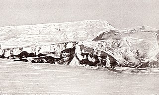
The Beardmore Glacier in Antarctica is one of the largest valley glaciers in the world, being 200 km (125 mi) long and having a width of 40 km (25 mi). It descends about 2,200 m (7,200 ft) from the Antarctic Plateau to the Ross Ice Shelf and is bordered by the Commonwealth Range of the Queen Maud Mountains on the eastern side and the Queen Alexandra Range of the Central Transantarctic Mountains on the western. Its mouth is east of the Lennox-King Glacier. It is northwest of the Ramsey Glacier.
The Reedy Glacier is a major glacier in Antarctica, over 100 nautical miles long and 6 to 12 nautical miles wide, descending from the polar plateau to the Ross Ice Shelf between the Michigan Plateau and Wisconsin Range in the Transantarctic Mountains. It marks the limits of the Queen Maud Mountains on the west and the Horlick Mountains on the east.

The Axel Heiberg Glacier in Antarctica is a valley glacier, 30 nautical miles long, descending from the high elevations of the Antarctic Plateau into the Ross Ice Shelf between the Herbert Range and Mount Don Pedro Christophersen in the Queen Maud Mountains.

The Leverett Glacier is about 50 nautical miles (90 km) long and 3 to 4 nautical miles wide, flowing from the Antarctic Plateau to the south end of the Ross Ice Shelf through the Queen Maud Mountains. It is an important part of the South Pole Traverse from McMurdo Station to the Admundson–Scott South Pole Station, providing a route for tractors to climb from the ice shelf through the Transantarctic Mountains to the polar plateau.
The Keltie Glacier is a large Antarctic glacier, 30 nautical miles (56 km) long, draining from Pain Névé southwest around the southern extremity of the Commonwealth Range, and then northwest to enter Beardmore Glacier at Ranfurly Point. It was discovered by the British Antarctic Expedition, 1907–09, under Ernest Shackleton, who named it for Sir John Scott Keltie, Secretary of the Royal Geographical Society, 1892–1915.
The Amundsen Glacier is a major Antarctic glacier, about 7 to 11 km wide and 150 km (80 nmi) long. It originates on the Antarctic Plateau where it drains the area to the south and west of Nilsen Plateau, then descends through the Queen Maud Mountains to enter the Ross Ice Shelf just west of the MacDonald Nunataks.
The Dominion Range is a broad mountain range, about 30 nautical miles long, forming a prominent salient at the juncture of the Beardmore and Mill glaciers in Antarctica. The range is part of the Queen Maud Mountains The range was discovered by the British Antarctic Expedition, 1907–09 and named by Ernest Shackleton for the Dominion of New Zealand, which generously aided the expedition.
Mill Glacier is a tributary glacier, 10 nautical miles (19 km) wide, flowing northwest between the Dominion Range and the Supporters Range into Beardmore Glacier, Antarctica. It was discovered by the British Antarctic Expedition, 1907–09, and named for Hugh Robert Mill, a British geographer and Antarctic historian.

Shackleton Glacier is a major Antarctic glacier, over 60 nautical miles long and from 5 to 10 nautical miles wide, descending from the Antarctic Plateau from the vicinity of Roberts Massif and flowing north through the Queen Maud Mountains to enter the Ross Ice Shelf between Mount Speed and Waldron Spurs. Discovered by the United States Antarctic Service (USAS) (1939–41) and named by the Advisory Committee on Antarctic Names (US-ACAN) for Sir Ernest Shackleton, British Antarctic explorer.
The Herbert Range is a range in the Queen Maud Mountains of Antarctica, extending from the edge of the Antarctic Plateau to the Ross Ice Shelf between the Axel Heiberg Glacier and Strom Glacier. Named by the New Zealand Antarctic Place-Names Committee (NZ-APC) for Walter W. Herbert, leader of the Southern Party of the New Zealand GSAE (1961–62) which explored the Axel Heiberg Glacier area.
The Prince Olav Mountains is a mountain group in the Queen Maud Mountains in Antarctica stretching from Shackleton Glacier to Liv Glacier at the head of the Ross Ice Shelf.
Quarles Range is a high and rugged range of the Queen Maud Mountains, extending from the polar plateau between Cooper Glacier and Bowman Glacier and terminating near the edge of Ross Ice Shelf.
Bennett Platform is a high, nearly flat, snow-free mesa of dark rock of Antarctica, about 5 nautical miles long and 2.5 nautical miles wide, located immediately east of Mount Black, on the west side of Shackleton Glacier.
The Grosvenor Mountains are a group of widely scattered mountains and nunataks rising above the Antarctic polar plateau east of the head of Mill Glacier, extending from Mount Pratt in the north to the Mount Raymond area in the south, and from Otway Massif in the northwest to Larkman Nunatak in the southeast.
The Duncan Mountains are a group of rugged coastal foothills, about 18 nautical miles long, extending from the mouth of Liv Glacier to the mouth of Strom Glacier at the head of the Ross Ice Shelf in Antarctica.
The Harold Byrd Mountains are a group of exposed mountains and nunataks which extend in an east–west direction between the lower part of Leverett Glacier and the head of the Ross Ice Shelf in Antarctica. They were discovered in December 1929 by the Byrd Antarctic Expedition geological party under Laurence Gould, and named by Rear Admiral Richard E. Byrd for D. Harold Byrd, a cousin of his and a contributor towards the purchase of furs for the expedition.
The Medina Peaks are rugged, mainly ice-free, peaks surmounting a ridge 15 nautical miles long, extending north along the east side of Goodale Glacier to the edge of the Ross Ice Shelf, Antarctica.
Roberts Massif is a remarkable snow-free massif at the head of Shackleton Glacier. It rises to over 2,700 metres (8,900 ft) and is about 60 square nautical miles in area.
The La Gorce Mountains are a group of mountains, 20 nautical miles long, standing between the tributary Robison Glacier and Klein Glacier at the east side of the upper reaches of the Scott Glacier, in the Queen Maud Mountains of Antarctica.
The Lillie Range in Antarctica extends northward from the Prince Olav Mountains to the Ross Ice Shelf. Mounts Hall, Daniel, Krebs and Mason are in the range.


