Beaver Glacier may refer to:
Beaver Glacier is a glacier about 15 miles (24 km) long and 4 miles (6 km) wide, flowing west into Amundsen Bay between Auster Glacier and Mount Gleadell. The head of Beaver Glacier is located very close to the base of Mount King in Enderby Land. It was visited by an Australian National Antarctic Research Expeditions (ANARE) party on October 28, 1956, and named after the Beaver aircraft used by ANARE in coastal exploration.
Rayner Glacier is a prominent glacier, 19 kilometres (10 nmi) wide, flowing north to the coast of Enderby Land just west of Condon Hills. It was sighted in October 1956 by Squadron Leader D. Leckie during a flight in an ANARE Beaver aircraft, and named by ANCA for J.M. Rayner, Director of the Bureau of Mineral Resources in the Australian Department of National Development.

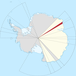
Enderby Land is a projecting landmass of Antarctica. Its shore extends from Shinnan Glacier at about 67°55′S44°38′E to William Scoresby Bay at 67°24′S59°34′E, approximately 1⁄24 of the earth's longitude. It was first documented in western and eastern literature in February 1831 by John Biscoe aboard the whaling brig Tula, and named after the Enderby Brothers of London, the ship's owners who encouraged their captains to combine exploration with sealing.
Kemp Land is a thin sliver of Antarctica including, and lying inland from, the Kemp Coast. Part of the Australian Antarctic claim, it is defined as lying between 56° 25' E and 59° 34' E, and, as with other sectors of the Antarctic, is deemed being limited by the 60° S parallel. It is bounded in the east by Mac. Robertson Land and in the west by Enderby Land. Kemp Land includes one major group of islands, the Øygarden Group.
The Twelfth Soviet Antarctic Expedition was an expedition by the Soviet Union to Antarctica.

Shinnan Glacier is a glacier which flows northwest to the coast just east of Shinnan Rocks and marks the division between Queen Maud Land and Enderby Land. Mapped from surveys and air photos by Japanese Antarctic Research Expedition (JARE), 1957–62, and named Shinnan Hyōga.
Kichenside Glacier is a glacier, 15 nautical miles (28 km) long and 3 to 5 nautical miles wide, flowing northeast into the southern part of the Hannan Ice Shelf on the coast of Enderby Land, Antarctica. It was charted from air photos taken from an Australian National Antarctic Research Expeditions aircraft in 1956, and was named by the Antarctic Names Committee of Australia for Squadron Leader James C. Kichenside, RAAF, officer commanding the Antarctic Flight at Mawson Station in 1960.
Assender Glacier is a glacier flowing west into Spooner Bay in Enderby Land, Antarctica. It was plotted from air photos taken from Australian National Antarctic Research Expeditions aircraft in 1956, and named by the Antarctic Names Committee of Australia for Pilot Officer Ken J. Assender, RAAF, pilot at Mawson Station in 1959.

Mount Elkins, also known as Jökelen is a dark, steep-sided mountain with three major peaks, the highest 2,300 meters (7,500 ft) above sea level, in the Napier Mountains of Enderby Land. Enderby Land is part of East Antarctica and is claimed by Australia as part of the Australian Antarctic Territory. The mountain was named after Terence James Elkins, an ionospheric physicist with the Australian National Antarctic Research Expeditions at Mawson Station in 1960.
Sydney Lorrimar Kirkby, is an Australian surveyor and Antarctic explorer.
Samuel Enderby & Sons was a whaling and sealing company based in London, England, founded circa 1775 by Samuel Enderby (1717–1797). The company was significant in the history of whaling in the United Kingdom, not least for encouraging their captains to combine exploration with their business activities, and sponsored several of the earliest expeditions to the subantarctic, Southern Ocean and Antarctica itself.
Rippon Glacier is a small glacier located in Kemp Land, East Antarctica. It is close east of Seaton Glacier, flowing southward into Edward VIII Ice Shelf.
Mount King is a large, smooth-crested mountain in the eastern extremity of the Tula Mountains. Part of the Australian Antarctic Gazetteer and the SCAR Composite Gazetteer of Antarctica, it is located in Enderby Land, East Antarctica, which is claimed by Australia as part of the Australian Antarctic Territory. The head of Beaver Glacier is located very close to the base of Mount King.
Demidov Island is a small island 9.3 kilometres (5 nmi) north of the mouth of Rayner Glacier and 17 kilometres (9 nmi) southwest of the Hydrographer Islands along the coast of Enderby Land. It appears that the island was mapped by both the Australian National Antarctic Research Expeditions and the Soviet expedition in 1957. It was named by the Soviet expedition for Lieutenant Dimitri Demidov of the Russian expedition of 1819–21 under Fabian Gottlieb von Bellingshausen.
Molle Glacier is a glacier, 4 nautical miles (7 km) wide, flowing north-northeast into the northern part of the Hannan Ice Shelf, Enderby Land, Antarctica. It was charted from air photos taken by Australian National Antarctic Research Expeditions in 1956, and was named by the Antarctic Names Committee of Australia for J.D. Molle, a radio officer at Davis Station in 1960.
Hays Glacier is a glacier flowing north into the head of Spooner Bay, Enderby Land, Antarctica. It was plotted from air photos taken by the Australian National Antarctic Research Expeditions (ANARE) in 1956, and was named for J. Hays, a United States observer with the ANARE which made a landing nearby.

Wood Enderby is a village and civil parish in the East Lindsey district of Lincolnshire, England. It is situated approximately 4 miles (6 km) south from Horncastle. The civil parish includes the hamlets of Cluxby Puckacre and Wilksby.
