
The Ross Ice Shelf is the largest ice shelf of Antarctica. It is several hundred metres thick. The nearly vertical ice front to the open sea is more than 600 kilometres (370 mi) long, and between 15 and 50 metres high above the water surface. Ninety percent of the floating ice, however, is below the water surface.

An ice shelf is a large platform of glacial ice floating on the ocean, fed by one or multiple tributary glaciers. Ice shelves form along coastlines where the ice thickness is insufficient to displace the more dense surrounding ocean water. The boundary between the ice shelf (floating) and grounded ice is referred to as the grounding line; the boundary between the ice shelf and the open ocean is the ice front or calving front.

Lake Vida is a hypersaline lake in Victoria Valley, the northernmost of the large McMurdo Dry Valleys, on the continent of Antarctica. It is isolated under year-round ice cover, and is considerably more saline than seawater. It came to public attention in 2002 when microbes frozen in its ice cover for more than 2,800 years were successfully thawed and reanimated.
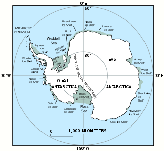
The West Antarctic Ice Sheet (WAIS) is the segment of the continental ice sheet that covers West Antarctica, the portion of Antarctica on the side of the Transantarctic Mountains that lies in the Western Hemisphere. It is classified as a marine-based ice sheet, meaning that its bed lies well below sea level and its edges flow into floating ice shelves. The WAIS is bounded by the Ross Ice Shelf, the Ronne Ice Shelf, and outlet glaciers that drain into the Amundsen Sea.

Berkner Island is an Antarctic ice rise, where bedrock below sea level has caused the surrounding ice sheet to create a dome. If the ice cap were removed, the island would be underwater. Berkner Island is completely ice-covered and is about 320 kilometres (200 mi) long and 150 kilometres (93 mi) wide, with an area of 44,000 km2 (17,000 sq mi). It is surrounded by the Filchner-Ronne Ice Shelf. The northernmost point of the Berkner is about 20 kilometres (12 mi) from the open sea. It lies in the overlapping portion of the Argentine and the British Antarctic territorial claims.

The Larsen Ice Shelf is a long ice shelf in the northwest part of the Weddell Sea, extending along the east coast of the Antarctic Peninsula from Cape Longing to Smith Peninsula. It is named after Captain Carl Anton Larsen, the master of the Norwegian whaling vessel Jason, who sailed along the ice front as far as 68°10' South during December 1893. In finer detail, the Larsen Ice Shelf is a series of shelves that occupy distinct embayments along the coast. From north to south, the segments are called Larsen A, Larsen B, and Larsen C by researchers who work in the area. Further south, Larsen D and the much smaller Larsen E, F and G are also named.

Denman Glacier is a glacier 11 to 16 km wide, descending north some 110 km (70 mi), which debouches into the Shackleton Ice Shelf east of David Island, Queen Mary Land. It was discovered in November 1912 by the Western Base party of the Australasian Antarctic Expedition under Sir Douglas Mawson. Mawson named the glacier for Lord Denman, Governor-General of Australia in 1911, a patron of the expedition.

Pine Island Glacier (PIG) is a large ice stream, and the fastest melting glacier in Antarctica, responsible for about 25% of Antarctica's ice loss. The glacier ice streams flow west-northwest along the south side of the Hudson Mountains into Pine Island Bay, Amundsen Sea, Antarctica. It was mapped by the United States Geological Survey (USGS) from surveys and United States Navy (USN) air photos, 1960–66, and named by the Advisory Committee on Antarctic Names (US-ACAN) in association with Pine Island Bay.

Thwaites Glacier is an unusually broad and vast Antarctic glacier located east of Mount Murphy, on the Walgreen Coast of Marie Byrd Land. It was initially sighted by polar researchers in 1940, mapped in 1959–1966 and officially named in 1967, after the late American glaciologist Fredrik T. Thwaites. The glacier flows into Pine Island Bay, part of the Amundsen Sea, at surface speeds which exceed 2 kilometres (1.2 mi) per year near its grounding line. Its fastest-flowing grounded ice is centered between 50 and 100 kilometres east of Mount Murphy. Like many other parts of the cryosphere, it has been adversely affected by climate change, and provides one of the more notable examples of the retreat of glaciers since 1850.

An ice stream is a region of fast-moving ice within an ice sheet. It is a type of glacier, a body of ice that moves under its own weight. They can move upwards of 1,000 metres (3,300 ft) a year, and can be up to 50 kilometres (31 mi) in width, and hundreds of kilometers in length. They tend to be about 2 km (1.2 mi) deep at the thickest, and constitute the majority of the ice that leaves the sheet. In Antarctica, the ice streams account for approximately 90% of the sheet's mass loss per year, and approximately 50% of the mass loss in Greenland.
Whillans Ice Stream is a glaciological feature of the West Antarctic Ice Sheet, formerly known as Ice Stream B, renamed in 2001 in honor of Ohio State University glaciologist Ian Whillans.

Totten Glacier is a large glacier draining a major portion of the East Antarctic Ice Sheet, through the Budd Coast of Wilkes Land in the Australian Antarctic Territory. The catchment drained by the glacier is estimated at 538,000 km2 (208,000 sq mi), extending approximately 1,100 km (680 mi) into the interior and holds the potential to raise sea level by at least 3.5 m (11 ft). Totten drains northeastward from the continental ice but turns northwestward at the coast where it terminates in a prominent tongue close east of Cape Waldron. It was first delineated from aerial photographs taken by USN Operation Highjump (1946–47), and named by Advisory Committee on Antarctic Names (US-ACAN) for George M. Totten, midshipman on USS Vincennes of the United States Exploring Expedition (1838–42), who assisted Lieutenant Charles Wilkes with correction of the survey data obtained by the expedition.

The East Antarctic Ice Sheet (EAIS) lies between 45° west and 168° east longitudinally. It was first formed around 34 million years ago, and it is the largest ice sheet on the entire planet, with far greater volume than the Greenland ice sheet or the West Antarctic Ice Sheet (WAIS), from which it is separated by the Transantarctic Mountains. The ice sheet is around 2.2 km (1.4 mi) thick on average and is 4,897 m (16,066 ft) at its thickest point. It is also home to the geographic South Pole, South Magnetic Pole and the Amundsen–Scott South Pole Station.

Eric J. Rignot is the Donald Bren, Distinguished and Chancellor Professor of Earth system science at the University of California, Irvine, and a Senior Research Scientist for the Radar Science and Engineering Section at NASA's Jet Propulsion Laboratory. He studies the interaction of the polar ice sheets in Greenland and Antarctica with global climate using a combination of satellite remote sensing, airborne remote sensing, understanding of physical processes controlling glacier flow and ice melt in the ocean, field methods, and climate modeling. He was elected at the National Academy of Sciences in 2018.
Rutford Ice Stream is a major Antarctic ice stream, about 290 kilometres (180 mi) long and over 24 kilometres (15 mi) wide, which drains southeastward between the Sentinel Range, Ellsworth Mountains and Fletcher Ice Rise into the southwest part of Ronne Ice Shelf. Named by US-ACAN for geologist Robert Hoxie Rutford, a member of several USARP expeditions to Antarctica; leader of the University of Minnesota Ellsworth Mountains Party, 1963-1964. Rutford served as Director of the Division of Polar Programs, National Science Foundation, 1975-1977.
MacAyeal Ice Stream, formerly Ice Stream E, is an ice stream in Antarctica flowing west to the juncture of Shirase Coast and Siple Coast between Bindschadler Ice Stream and Echelmeyer Ice Stream. It is one of several major ice streams draining from Marie Byrd Land into the Ross Ice Shelf. The ice streams were investigated and mapped by U.S. Antarctic Research Program personnel in a number of field seasons from 1983 to 1984 onwards and named Ice Stream A, B, C, etc., according to their position from south to north. The name was changed from Ice Stream E by the Advisory Committee on Antarctic Names in 2002 to honor Douglas R. MacAyeal of the Department of Geophysical Sciences, University of Chicago, a U.S. Antarctic Program investigator in the Ross Sea area including study of the Ross Ice Shelf, the West Antarctic Ice Sheet and the Marie Byrd Land ice streams, 1989–2002. Shabtaie Ice Ridge sits between the MacAyeal and Bundschadler ice streams.

Crane Glacier is a narrow glacier which flows 30 miles (50 km) in an east-northeasterly direction along the northwest side of Aristotle Mountains to enter Spillane Fjord south of Devetaki Peak, on the east coast of the Antarctic Peninsula. Sir Hubert Wilkins photographed this feature from the air in 1928 and gave it the name "Crane Channel", after C.K. Crane of Los Angeles, reporting that it appeared to be a channel cutting in an east-west direction across the peninsula. The name was altered to "Crane Inlet" following explorations along the west coast of the peninsula in 1936 by the British Graham Land Expedition, which proved that no through channel from the east coast existed as indicated by Wilkins. Comparison of Wilkins' photograph of this feature with those taken in 1947 by the Falklands Islands Dependencies Survey shows that Wilkins' "Crane Channel" is this glacier, although it lies about 75 miles (120 km) northeast of the position originally reported by Wilkins.

Allison Glacier is an ice stream on the west side of Heard Island in the southern Indian Ocean. Allison Glacier flows from Big Ben massif down to the sea to the south of Cape Gazert. To the north of Allison Glacier is Vahsel Glacier, whose terminus is at South West Bay, between Erratic Point and Cape Gazert. Immediately to the north of Vahsel Glacier is Schmidt Glacier, whose terminus is located between Mount Drygalski and North West Cornice. To the south of Allison Glacier is Abbotsmith Glacier, while Cape Gazert is immediately west.
