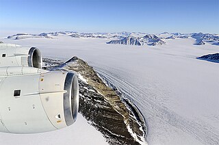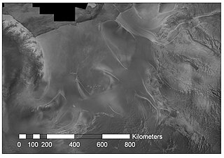
Berkner Island is an Antarctic ice rise, where bedrock below sea level has caused the surrounding ice sheet to create a dome. If the ice cap were removed, the island would be underwater. Berkner Island is completely ice-covered and is about 320 kilometres (200 mi) long and 150 kilometres (93 mi) wide, with an area of 44,000 km2 (17,000 sq mi). It is surrounded by the Filchner-Ronne Ice Shelf. The northernmost point of the Berkner is about 20 kilometres (12 mi) from the open sea. It lies in the overlapping portion of the Argentine and the British Antarctic territorial claims.

Marie Byrd Land (MBL) is an unclaimed region of Antarctica. With an area of 1,610,000 km2 (620,000 sq mi), it is the largest unclaimed territory on Earth. It was named after the wife of American naval officer Richard E. Byrd, who explored the region in the early 20th century.

The Dater Glacier is a steep valley glacier in Antarctica, 24 nautical miles long and from 1 to 3 nautical miles wide, flowing northeast in a sinuous course from the eastern slopes of the Vinson Massif between Sullivan Heights and Veregava Ridge to Rutford Ice Stream which borders the eastern flank of the Sentinel Range, Ellsworth Mountains. At the lower end the Dater Glacier coalesces with the terminus of the Ellen Glacier, the two emerging from the Sentinel Range as one stream just north of the Flowers Hills.

The Ellen Glacier is a glacier in the central Sentinel Range of the Ellsworth Mountains of Antarctica. It drains the eastern slopes of Mount Anderson and Long Gables and flows generally southeast for 22 nautical miles to Barnes Ridge, where it leaves the range and enters the south flowing Rutford Ice Stream.

Koettlitz Glacier is a large Antarctic glacier lying west of Mount Morning and Mount Discovery in the Royal Society Range, flowing from the vicinity of Mount Cocks northeastward between Brown Peninsula and the mainland into the ice shelf of McMurdo Sound.

George VI Sound or Canal Jorge VI or Canal Presidente Sarmiento or Canal Seaver or King George VI Sound or King George the Sixth Sound is a major bay/fault depression, 300 miles (483 km) long and mainly covered by a permanent ice shelf. It is in the shape of the letter J without any upper bar. It lines the east and south shores of Alexander Island, separating it from the vestigial, quite small, Wordie Ice Shelf and Palmer Land and the north-facing "English Coast". A quite central point of it is 71°S68°W.

Denman Glacier is a glacier that is 11 to 16 km wide, descending north some 110 km (70 mi), which debouches into the Shackleton Ice Shelf east of David Island, Queen Mary Land. It was discovered in November 1912 by the Western Base party of the Australasian Antarctic Expedition under Sir Douglas Mawson. Mawson named the glacier for Lord Denman, Governor-General of Australia in 1911, a patron of the expedition.
George V Coast is that portion of the coast of Antarctica lying between Point Alden, at 148°2′E, and Cape Hudson, at 153°45′E.

Pine Island Glacier (PIG) is a large ice stream, and the fastest melting glacier in Antarctica, responsible for about 25% of Antarctica's ice loss. The glacier ice streams flow west-northwest along the south side of the Hudson Mountains into Pine Island Bay, Amundsen Sea, Antarctica. It was mapped by the United States Geological Survey (USGS) from surveys and United States Navy (USN) air photos, 1960–66, and named by the Advisory Committee on Antarctic Names (US-ACAN) in association with Pine Island Bay.
Radioglaciology is the study of glaciers, ice sheets, ice caps and icy moons using ice penetrating radar. It employs a geophysical method similar to ground-penetrating radar and typically operates at frequencies in the MF, HF, VHF and UHF portions of the radio spectrum. This technique is also commonly referred to as "Ice Penetrating Radar (IPR)" or "Radio Echo Sounding (RES)".
The Institute Ice Stream is an ice stream flowing north into the Ronne Ice Shelf, Antarctica, southeast of Hercules Inlet. The feature was traversed by the United States Antarctic Research Program (USARP) Ellsworth–Byrd Seismic Party, 1958–59, and the USARP – University of Wisconsin Seismic Party, 1963–64. It was delineated by the Scott Polar Research Institute – National Science Foundation – Technical University of Denmark airborne radio echo sounding program, 1967–79, and in association with Foundation Ice Stream and Support Force Glacier, named after the Scott Polar Research Institute, Cambridge, England.
The Mulock Glacier is a large, heavily crevassed glacier which flows into the Ross Ice Shelf 40 kilometers south of the Skelton Glacier in the Ross Dependency, Antarctica.

The George VI Ice Shelf is an extensive ice shelf that occupies George VI Sound which separates Alexander Island from Palmer Land in Antarctica. The ice shelf extends from Ronne Entrance, at the southwest end of the sound, to Niznik Island, about 30 nautical miles (56 km) south of the north entrance between Cape Brown and Cape Jeremy. It was named by the UK Antarctic Place-Names Committee in association with George VI Sound.

Rutford Ice Stream is a major Antarctic ice stream, about 290 kilometres (180 mi) long and over 24 kilometres (15 mi) wide, which drains southeastward between the Sentinel Range, Ellsworth Mountains and Fletcher Ice Rise into the southwest part of Ronne Ice Shelf. Named by US-ACAN for geologist Robert Hoxie Rutford, a member of several USARP expeditions to Antarctica; leader of the University of Minnesota Ellsworth Mountains Party, 1963-1964. Rutford served as Director of the Division of Polar Programs, National Science Foundation, 1975-1977.

Crane Glacier is a narrow glacier which flows 30 miles (50 km) in an east-northeasterly direction along the northwest side of Aristotle Mountains to enter Spillane Fjord south of Devetaki Peak, on the east coast of the Antarctic Peninsula. Sir Hubert Wilkins photographed this feature from the air in 1928 and gave it the name "Crane Channel", after C.K. Crane of Los Angeles, reporting that it appeared to be a channel cutting in an east-west direction across the peninsula. The name was altered to "Crane Inlet" following explorations along the west coast of the peninsula in 1936 by the British Graham Land Expedition, which proved that no through channel from the east coast existed as indicated by Wilkins. Comparison of Wilkins' photograph of this feature with those taken in 1947 by the Falkland Islands Dependencies Survey shows that Wilkins' "Crane Channel" is this glacier, although it lies about 75 miles (120 km) northeast of the position originally reported by Wilkins.

Jones Ice Shelf was the ice shelf occupying the Jones Channel, between the Arrowsmith Peninsula and Blaiklock Island, on the west coast of Graham Land, Antarctica. It was named by the UK Antarctic Place-Names Committee in 1981 in association with the channel.

Flask Glacier, is a gently-sloping glacier, 25 nautical miles long, flowing east from Bruce Plateau to enter Scar Inlet between Daggoo Peak and Spouter Peak in Graham Land, Antarctica. The lower reaches of this glacier were surveyed and photographed by the Falkland Islands Dependencies Survey (FIDS) in 1947. The entire glacier was photographed by the Falkland Islands and Dependencies Aerial Survey Expedition in 1955–56, and mapped by the FIDS in 1957. It was named by the UK Antarctic Place-names Committee after the third mate on the Pequod in Herman Melville's Moby-Dick; or, The White Whale.
Fletcher Ice Rise, or Fletcher Promontory, is a large ice rise, 100 miles (160 km) long and 40 miles (64 km) wide, at the southwest side of the Ronne Ice Shelf, Antarctica. The feature is completely ice covered and rises between Rutford Ice Stream and Carlson Inlet. The ice rise was observed, photographed and roughly sketched by Lieutenant Ronald F. Carlson, U.S. Navy, in the course of a C-130 aircraft flight of December 14–15, 1961 from McMurdo Sound to this vicinity and returning. It was mapped in detail by the U.S. Geological Survey from Landsat imagery taken 1973–74, and was named by the Advisory Committee on Antarctic Names for Joseph O. Fletcher, director of the Office of Polar Programs, National Science Foundation, 1971–74.
Monteverdi Peninsula is a large ice-covered peninsula lying between the Bach Ice Shelf and George VI Sound, forming the southernmost extremity of Alexander Island, Antarctica. The southern side of the feature was first seen and charted by Finn Ronne and Carl Eklund of the United States Antarctic Service, 1939–41, who traversed the entire length of George VI Sound. The peninsula was mapped from trimetrogon air photography taken by the Ronne Antarctic Research Expedition in 1947–48, and from survey by the Falkland Islands Dependencies Survey, 1948–50. It was named by the UK Antarctic Place-Names Committee after Italian composer Claudio Monteverdi.

Aster Glacier is an Antarctic glacier descending the east slope of Craddock Massif and flowing between Elfring Peak and Willis Ridge to Thomas Glacier in the Sentinel Range, Ellsworth Mountains in Antarctica. It was named by the Advisory Committee on Antarctic Names in 2006, after Richard Aster, Professor of Geophysics and Department Head of Geosciences at Colorado State University, whose research in Antarctica includes volcanological studies at the Mount Erebus volcano observatory on Ross Island, glaciological, oceanic, and tectonic seismic source studies, seismic tomography, ice shelf studies, and the coupling of solid Earth geophysics and Antarctic ice sheet evolution.


