
Orkney, also known as the Orkney Islands, is an archipelago in the Northern Isles of Scotland, situated off the north coast of the island of Great Britain. Orkney is 10 miles (16 km) north of the coast of Caithness and has about 70 islands, of which 20 are inhabited. The largest island, the Mainland, has an area of 523 square kilometres (202 sq mi), making it the sixth-largest Scottish island and the tenth-largest island in the British Isles. Orkney's largest settlement, and also its administrative centre, is Kirkwall.

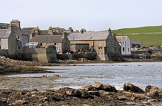
The Mainland, also known as Hrossey and Pomona, is the main island of Orkney, Scotland. Both of Orkney's burghs, Kirkwall and Stromness, lie on the island, which is also the heart of Orkney's ferry and air connections.
South Ronaldsay is one of the Orkney Islands off the north coast of Scotland. It is linked to the Orkney Mainland by the Churchill Barriers, running via Burray, Glimps Holm and Lamb Holm.
Lynch may refer to:
Howe may refer to:

The South Orkney Islands are a group of islands in the Southern Ocean, about 604 km (375 mi) north-east of the tip of the Antarctic Peninsula and 844 km (524 mi) south-west of South Georgia Island. They have a total area of about 620 km2 (240 sq mi). The islands are claimed both by Britain, and by Argentina as part of Argentine Antarctica. Under the 1959 Antarctic Treaty, sovereignty claims are held in abeyance.

Coronation Island is the largest of the South Orkney Islands, 25 nautical miles (46 km) long and from 3 to 8 nautical miles wide. The island extends in a general east–west direction, is mainly ice-covered and comprises numerous bays, glaciers and peaks, the highest rising to 1,265 metres (4,150 ft).

The subantarctic zone is a region in the Southern Hemisphere, located immediately north of the Antarctic region. This translates roughly to a latitude of between 46° and 60° south of the Equator. The subantarctic region includes many islands in the southern parts of the Atlantic, Indian, and Pacific oceans, especially those situated north of the Antarctic Convergence. Subantarctic glaciers are, by definition, located on islands within the subantarctic region. All glaciers located on the continent of Antarctica are by definition considered to be Antarctic glaciers.
The Orkney Islands Council, is the local authority for Orkney, Scotland. It was established in 1975 by the Local Government (Scotland) Act 1973 and was largely unaffected by the Scottish local government changes of the mid-1990s.
Laws Glacier is a confluent glacier system which flows into Marshall Bay on the south coast of Coronation Island, in the South Orkney Islands off Antarctica. It was surveyed in 1948–49 by the Falkland Islands Dependencies Survey (FIDS), and was named by the UK Antarctic Place-Names Committee for Richard M. Laws of the FIDS, leader and biologist at Signy Research Station in 1948 and 1949, and at South Georgia in 1951.
Beaufoy Ridge is a conspicuous black ridge, rising to 650 metres (2,130 ft) at its northwest end, standing at the west side of Sunshine Glacier and close north of Iceberg Bay on the south coast of Coronation Island, in the South Orkney Islands. It was named by the Falkland Islands Dependencies Survey, following their survey in 1948–49, after the cutter Beaufoy which, on 12 December 1821, under Michael McLeod, sailed to a position at least 60 nautical miles (110 km) west of the South Orkney Islands, where a chart annotation indicates that land was sighted, possibly Coronation Island.
Orwell Glacier is a small glacier, less than 0.5 nautical miles (0.9 km) long, which descends steeply from the south slopes of Snow Hills and terminates in 20 m ice cliffs along the south margin of Elephant Flats in the east part of Signy Island, in the South Orkney Islands. Surveyed by DI personnel in 1927 and named by them for the Norwegian transport throughout the seasons 1925–26 to 1929–30. Resurveyed by the Falkland Islands Dependencies Survey (FIDS) in 1947.
Sunshine Glacier is a glacier, 3 nautical miles (6 km) long and 2 nautical miles (3.7 km) wide, flowing south into Iceberg Bay on the south coast of Coronation Island, in the South Orkney Islands. It is the largest glacier on the south side of Coronation Island and terminates in ice cliffs up to 60 m high. Surveyed in 1948-49 by the Falkland Islands Dependencies Survey (FIDS) and so named by them because, when all else was in shadow, small gaps in the clouds above frequently allowed patches of sunshine to appear on the surface of this glacier. At the west side of Sunshine Glacier stands the conspicuous black ridge of Beaufoy Ridge, rising to 650 metres (2,130 ft) at its northwest end.
Moraine Valley is a valley filled with morainic debris, 0.75 nautical miles (1.4 km) long, which drains north into Elephant Flats on the east side of Signy Island, in the South Orkney Islands off Antarctica. In summer a stream, fed by the ice slopes at its south end, runs in this valley. It was named by the Falkland Islands Dependencies Survey following their survey of 1947.
McLeod Glacier is a glacier 1 nautical mile (2 km) long, flowing in a southeasterly direction into Clowes Bay on the south side of Signy Island, in the South Orkney Islands off Antarctica. It was named by the UK Antarctic Place-Names Committee in 1954 for Michael McLeod, following a survey by the Falkland Islands Dependencies Survey in 1947. On 12 December 1821, the cutter Beaufoy under McLeod sailed to a position at least 60 nautical miles (110 km) west of the South Orkney Islands, where a chart annotation indicates that land was sighted, possibly Coronation Island.
Roald Glacier is a glacier which flows from the vicinity of Mount Noble and Mount Sladen eastward into Gibbon Bay, on the east coast of Coronation Island in the South Orkney Islands. Chartered and named by the Norwegian whaling captain Petter Sorle in the period 1912–15. Surveyed in 1948-49 by the Falkland Islands Dependencies Survey (FIDS).