
Following is a list of glaciers of Bouvet Island in Antarctica. This list may not reflects recently named glaciers in Bouvet Island.
Contents
Following is a list of glaciers of Bouvet Island in Antarctica. This list may not reflects recently named glaciers in Bouvet Island.
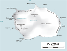
54°26′53″S3°21′09″E / 54.4481°S 3.3525°E . [lower-alpha 1] A glacier which flows to the south coast of Bouvetøya, 1 nautical mile (1.9 km; 1.2 mi) east of Cato Point. First charted in 1898 by a German expedition under Karl Chun. Recharted in December 1927 by a Norwegian expedition under Capt. Harald Horntvedt. Named by Horntvedt after Lars Christensen, sponsor of the expedition. Not: Christensenbreen, Christensens Bre. [1]
54°25′S3°21′E / 54.417°S 3.350°E . A small glacier flowing to the north coast of Bouvetøya immediately east of Cape Circoncision. First charted in 1898 by a German expedition under Karl Chun. Recharted in December 1927 by a Norwegian expedition which named it for Harald Horntvedt, captain of the expedition ship Norvegia. Not: Horntvedtbreen, Horntvedts Bre. [2]
54°25′S3°22′E / 54.417°S 3.367°E . A glacier which flows to the north coast of Bouvetøya, 1 nautical mile (1.9 km; 1.2 mi) eastward of Cape Circoncision. First charted and named by a German expedition under Karl Chun which visited the island in the Valdivia in 1898. Count Arthur von Posadowsky-Wehner, Imperial Home Secretary, was instrumental in obtaining government sponsorship of the expedition. Not: Posadowskybreen, Posadowsky s Bre. [3]

Cape Circoncision is a peninsula on the north-western edge of subantarctic Bouvet Island. The small peninsula was sighted by the French naval exploration that was led by Jean-Baptiste Charles Bouvet de Lozier on 1 January 1739, the Feast of the Circumcision day—thus the name. The cape provided the location for the base-camp of the 1928–1929 Norwegian expedition.
Sachse Rocks is a group of submerged rocks which lie close to the northern coast of the island of Bouvetoya and approximately 0.2 miles (0.3 km) southeast of Cape Valdivia. The rocks were charted and named by the Norwegian expedition, 1927–28, under Captain Harald Horntvedt. Named for Walter Sachse, a navigation officer on the German vessel SS Valdivia who in 1898 accurately fixed the position of the island for the first time.
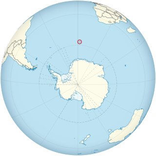
Bouvet Island is an island and dependency of Norway, and declared an uninhabited protected nature reserve. It is a subantarctic volcanic island, situated in the South Atlantic Ocean at the southern end of the Mid-Atlantic Ridge, and is the world's most remote island. It is not part of the southern region covered by the Antarctic Treaty System.
Cape Valdivia is the northernmost point on Bouvet Island in the South Atlantic Ocean. The subantarctic Bouvet Island is administered by Norway.

Robertson Bay is a large, roughly triangular bay that indents the north coast of Victoria Land between Cape Barrow and Cape Adare. Discovered in 1841 by Captain James Clark Ross, Royal Navy, who named it for Dr. John Robertson, surgeon on HMS Terror.

Posadowsky Glacier is a glacier about 9 nautical miles long, flowing north to Posadowsky Bay immediately east of Gaussberg. Posadowsky Bay is an open embayment, located just east of the West Ice Shelf and fronting on the Davis Sea in Kaiser Wilhelm II Land. Kaiser Wilhelm II Land is the part of East Antarctica lying between Cape Penck, at 87°43'E, and Cape Filchner, at 91°54'E, and is claimed by Australia as part of the Australian Antarctic Territory. Other notable geographic features in this area include Drygalski Island, located 45 mi NNE of Cape Filchner in the Davis Sea, and Mirny Station, a Russian scientific research station.
Williams Reef is a reef which extends southward for about 0.5 nautical miles (0.9 km) from Cape Fie in the island of Bouvetøya. The reef was charted in 1898 by a German expedition in the Valdivia under Carl Chun. It was recharted in December 1927 by a Norwegian expedition and named for Captain John Williams, an American sealer who had visited Bouvetoya in the schooner Golden West in 1878, making a landing on the island.
Benn Skerries are a small group of rocks which extend up to 0.25 nautical miles (0.5 km) westward from Norvegia Point on the island of Bouvetøya. They were charted and named in December 1927 by a Norwegian expedition in the Norvegia under Captain Harald Horntvedt.
Bolle Bay is a cove indenting the western shore of Bouvetøya, entered on the southern side of Norvegia Point. Roughly charted in 1898 by the German expedition under Carl Chun, it was re-charted and named in December 1927 by a Norwegian expedition under Captain Harald Horntvedt.
Cato Point is a headland forming the southwest extremity of Bouvet Island. It was first charted in 1898 by a German expedition under Carl Chun. The Norwegian expedition under Captain Harald Horntvedt made a landing here from the Norvegia in December 1927; they applied the name.
Norris Reef is a reef lying close off the western shore of the island of Bouvetøya, 0.5 nautical miles (0.9 km) southwest of Cape Circoncision. First charted in 1898 by a German expedition under Carl Chun. Recharted in December 1927 by a Norwegian expedition under Captain Harald Horntvedt. Named by the Norwegians after British sealer Captain George Norris who, commanding the sealers Sprightly and Lively, visited Bouvetoya in 1825.
Norvegia Point, is a point 2 nautical miles (3.7 km) south of Cape Circoncision on the west side of the island of Bouvetøya. First roughly charted from the Valdivia in 1898 by a German expedition under Carl Chun. Recharted in December 1927 by a Norwegian expedition under Captain Harald Horntvedt. Named by Horntvedt after his expedition ship, the Norvegia I.
Cape Fie, located at 54°27′S3°28′E, is a cape marking the southeast extremity of Bouvetøya in the South Atlantic Ocean. It was first roughly charted in 1898 by a German expedition under Carl Chun, and was re-charted and named by the Norwegian expedition under Captain Harald Horntvedt who explored the area from the Norvegia in December 1927.
Morrell Reef is a reef reported to lie close off the southeast coast of Bouvetøya, about 0.4 nautical miles (0.7 km) northward of Cape Fie. It was first charted in 1898 by a German expedition under Carl Chun, and was recharted in December 1927 by a Norwegian expedition under Captain Harald Horntvedt. The reef was named by the Norwegians after Captain Benjamin Morrell, an American sealer who visited the northwest side of Bouvetøya in the Wasp in 1822, perhaps making the first landing on the island.
Cape Lollo, located at 54°25′S3°29′E, is a cape which forms the northeastern extremity of Bouvetøya in Norway. It was first charted in 1898 by a German expedition under Carl Chun, and was recharted and named in December 1927 by a Norwegian expedition under Captain Harald Horntvedt.
Spiess Rocks is a group of submerged rocks which extend up to 0.4 nautical miles (0.7 km) northeast of Cape Lollo on the island of Bouvetøya. First charted in December 1927 by a Norwegian expedition under Captain Harald Horntvedt. Named by the Norwegians for Captain Fritz A. Spiess, leader of the German expedition which visited Bouvetoya on board the Meteor in 1926.
Rustad Knoll is a rounded, snow-topped elevation which surmounts the south shore of the island of Bouvetøya immediately east of Cato Point. First charted in 1898 by a German expedition under Carl Chun. The knoll was recharted in December 1927 by the Norvegia expedition under Captain Harald Horntvedt. They named it for Ditlef Rustad who was in charge of the biological research of the expedition.
Lykketoppen, occasionally anglicized as Lykke Peak, is a snow-covered, 765-meter (2,510 ft) tall summit that surmounts the southwest part of Bouvetøya, standing 1 nautical mile (2 km) east of Norvegia Point. It was first roughly charted in 1898 by a German expedition under Carl Chun, and was recharted and named in December 1927 by the First Norvegia Expedition under Captain Harald Horntvedt.
Larsøya, sometimes anglicized as Lars Island, is a rocky island, less than 0.2 nautical miles (0.4 km) long, which lies just off the southwestern extremity of the island of Bouvetøya in the South Atlantic Ocean. It was first roughly charted in 1898 by a German expedition under Carl Chun. The Norwegian expedition under Captain Harald Horntvedt made a landing on the island from the ship Norvegia in December 1927, and named it after Lars Christensen, sponsor of the expedition.
Lindsay Reef is a reef lying close north of Cape Meteor on the east side of the island of Bouvetøya in the South Atlantic Ocean. The reef was first charted in 1898 by a German expedition under Carl Chun. It was recharted in December 1927 by a Norwegian expedition under Captain Harald Horntvedt, and named by the Norwegians after Captain James Lindsay, a British whaler in command of the Swan who, in the company of Captain Thomas Hopper with the Otter, sighted Bouvetøya in 1808.