
The Ellsworth Mountains are the highest mountain ranges in Antarctica, forming a 350 km (217 mi) long and 48 km (30 mi) wide chain of mountains in a north to south configuration on the western margin of the Ronne Ice Shelf in Marie Byrd Land. They are bisected by Minnesota Glacier to form the Sentinel Range to the north and the Heritage Range to the south. The former is by far the higher and more spectacular with Mount Vinson constituting the highest point on the continent. The mountains are located within the Chilean Antarctic territorial claim but outside of the Argentinian and British ones.

The Pensacola Mountains are a large group of mountain ranges of the Transantarctic Mountains System, located in the Queen Elizabeth Land region of Antarctica.
The Sentinel Range is a major mountain range situated northward of Minnesota Glacier and forming the northern half of the Ellsworth Mountains in Antarctica. The range trends NNW-SSE for about 185 km (115 mi) and is 24 to 48 km wide. Many peaks rise over 4,000 m (13,100 ft) and Vinson Massif (4892 m) in the southern part of the range is the highest elevation on the continent.

Palmer Land is the portion of the Antarctic Peninsula, Antarctica that lies south of a line joining Cape Jeremy and Cape Agassiz. This application of Palmer Land is consistent with the 1964 agreement between the Advisory Committee on Antarctic Names and the UK Antarctic Place-Names Committee, in which the name Antarctic Peninsula was approved for the major peninsula of Antarctica, and the names Graham Land and Palmer Land for the northern and southern portions, respectively. The line dividing them is roughly 69° S.

Minnesota Glacier is a broad glacier, about 40 nautical miles long and 5 nautical miles wide, flowing east through the Ellsworth Mountains in Antarctica, separating the Sentinel Range and the Heritage Range. It is nourished by ice from the plateau west of the mountains and by Nimitz Glacier and Splettstoesser Glacier, and merges into the larger Rutford Ice Stream at the eastern margin of the Ellsworth Mountains.
The Evans Ice Stream is a large ice stream draining from Ellsworth Land, between Cape Zumberge and Fowler Ice Rise, into the western part of the Ronne Ice Shelf. Mills Glacier flows adjacently into the ice stream from the southwest side. The feature was recorded on February 5, 1974, in Landsat imagery. It was named by the UK Antarctic Place-Names Committee for Stanley Evans, a British physicist who, starting in 1961, developed apparatus for radio echo sounding of icecaps and glaciers from aircraft; he carried out upper atmosphere research at Brunt Ice Shelf, 1956–57.

The Sikorski Glacier is a small glacier in the north-eastern part of the Noville Peninsula, Thurston Island, Ellsworth Land, Antarctica. It flows north-east to the Bellingshausen Sea between Mount Palmer and Mount Feury. It was first roughly delineated from aerial photos taken by the USN's Operation Highjump in 1946–47. It was named by the Advisory Committee on Antarctic Names (US-ACAN) for Stephen Sikorski, electronics technician on USS Glacier, who assisted in setting up an automatic weather station on Thurston Island during the USN's Bellingshausen Sea Expedition in February 1960.
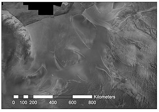
Rutford Ice Stream is a major Antarctic ice stream, about 290 kilometres (180 mi) long and over 24 kilometres (15 mi) wide, which drains southeastward between the Sentinel Range, Ellsworth Mountains and Fletcher Ice Rise into the southwest part of Ronne Ice Shelf. Named by US-ACAN for geologist Robert Hoxie Rutford, a member of several USARP expeditions to Antarctica; leader of the University of Minnesota Ellsworth Mountains Party, 1963-1964. Rutford served as Director of the Division of Polar Programs, National Science Foundation, 1975-1977.
Weyerhaeuser Glacier is a large glacier flowing north into Mercator Ice Piedmont close west of Mobiloil Inlet, on the east coast of Antarctic Peninsula. This glacier lies in the area first explored from the air by Sir Hubert Wilkins in 1928 and Lincoln Ellsworth in 1935, but it was first clearly delineated in aerial photographs taken by the United States Antarctic Service (USAS) in 1940. The glacier was resighted in 1947 by the Ronne Antarctic Research Expedition (RARE) under Ronne. He named it for F. K. Weyerhaeuser, of the Weyerhaeuser Timber Co., who contributed lumber and insulating material to the expedition.

The Flowers Hills are a triangular shaped group of hills, 34.6 kilometres (21.5 mi) long and 11.5 kilometres (7.1 mi) wide, with peaks of 1,240 metres (4,070 ft) and 1,504 metres (4,934 ft), extending along the eastern edge of the Sentinel Range, Ellsworth Mountains, Antarctica. The hills are bounded by Hansen Glacier and Dater Glacier to the west and north, Rutford Ice Stream to the east and Sikera Valley to the southwest, and separated from Doyran Heights to the west-southwest by Kostinbrod Pass. Their interior is drained by Lardeya Ice Piedmont and Valoga Glacier.
Mercator Ice Piedmont is a gently-sloping ice piedmont at the head of Mobiloil Inlet, formed by the confluence of the Gibbs, Lammers, Cole and Weyerhaeuser Glaciers in eastern Graham Land, Antarctica. The feature was first photographed from the air by Lincoln Ellsworth in November 1935, and was plotted from these photos by W.L.G. Joerg as the lower end of a "major valley depression" along the coast. It was first seen from the ground by Finn Ronne and Carl R. Eklund of the United States Antarctic Service, 1939–41, which also obtained air photos. The ice piedmont was surveyed by the Falkland Islands Dependencies Survey in December 1958, and was named by the UK Antarctic Place-Names Committee after Flemish mathematician and geographer Gerardus Mercator, the originator, in 1568, of the map projection which bears his name.
Lammers Glacier is a large glacier flowing east along the north side of Godfrey Upland into the Traffic Circle and Mercator Ice Piedmont, on the east coast of Graham Land, Antarctica. This glacier appears indistinctly in an aerial photograph taken by Sir Hubert Wilkins on 20 December 1928, but shows more clearly in aerial photographs taken by Lincoln Ellsworth in 1935 and the United States Antarctic Service in 1940. It was resighted in 1947 by the Ronne Antarctic Research Expedition under Finn Ronne, who named it for Lester Lammers, who had contributed nine grown husky dogs and four puppies to the expedition.

The Union Glacier Camp is the only private seasonally occupied camp site located in Ellsworth Land in Antarctica. The camp is located in the Heritage Range, below the Ellsworth Mountains, on Union Glacier, that gives the camp its name.
The Traverse Mountains of Antarctica are a group of almost ice-free mountains, rising to about 1,550 metres (5,090 ft), and including McHugo Peak, Mount Noel, Mount Allan and Mount Eissinger, between Eureka Glacier and Riley Glacier, east of Warren Ice Piedmont, in western Palmer Land. These mountains were first photographed from the air on November 23, 1935, by Lincoln Ellsworth and were mapped from these photographs by W.L.G. Joerg. They were first surveyed in 1936 by the British Graham Land Expedition (BGLE) under John Rymill and resurveyed in 1948 by the Falklands Islands Dependencies Survey. The name was first used by BGLE sledging parties because the mountains are an important landmark in the overland traverse from the Wordie Ice Shelf, down Eureka Glacier, to George VI Sound.

Ranuli Ice Piedmont is the glacier extending 7 nautical miles in south-southeast to north-northwest direction and 3 nautical miles in west-southwest to east-northeast direction on the east side of Sentinel Range in Ellsworth Mountains, Antarctica. It is draining the east slopes of Barnes Ridge to flow into Rutford Ice Stream to the east-northeast, Young Glacier to the north, and Ellen Glacier to the south.
Lardeya Ice Piedmont is the glacier extending 8.6 nautical miles in north-south direction and 4 nautical miles in east-west direction on the east side of Sentinel Range in Ellsworth Mountains, Antarctica. It is draining the northeast slopes of Flowers Hills to flow into Rutford Ice Stream to the east-northeast and Ellen Glacier to the north.
Sostra Heights are the heights rising ro 2352 m at Mount Malone on the east side of northern Sentinel Range in Ellsworth Mountains, Antarctica. They extend 22 km in northwest–southeast direction and 16.5 km in northeast–southwest direction. The heights are bounded by Embree Glacier to the south, Sabazios Glacier to the west, Newcomer Glacier to the north and Rutford Ice Stream to the east, and separated by Robinson Pass to the southwest from the side ridge that trends 9.15 km east-northeastwards from Mount Dalrymple on the main crest of Sentinel Range. Their interior is drained by Anchialus Glacier and Vit Ice Piedmont.
Anchialus Glacier is the 8.5 km long and 3.4 km wide glacier in Sostra Heights on the east side of northern Sentinel Range in Ellsworth Mountains, Antarctica. It is situated north of lower Embree Glacier, east of Sabazios Glacier, south of lower Newcomer Glacier and northwest of Vit Ice Piedmont. The glacier drains the northeast slopes of Mount Malone and the west slopes of Bracken Peak, flows northwards and joins Newcomer Glacier east of Mount Lanning.
Vit Ice Piedmont is the glacier extending 12 km in north-south direction and 6 km in east-west direction in Sostra Heights on the east side of northern Sentinel Range in Ellsworth Mountains, Antarctica. It is situated north of the end of Embree Glacier, east of Bracken Peak, southwest of Anchialus Glacier and south of the end of Newcomer Glacier. The glacier flows eastwards into Rutford Ice Stream.