
The Nimrod Glacier is a major glacier about 135 km (85 mi) long, flowing from the polar plateau in a northerly direction through the Transantarctic Mountains into the Ross Ice Shelf, Antarctica.
Smith Glacier is a low-gradient Antarctic glacier, over 160 km (100 mi) long, draining from Toney Mountain in an ENE direction to Amundsen Sea. A northern distributary, Kohler Glacier, drains to Dotson Ice Shelf but the main flow passes to the sea between Bear Peninsula and Mount Murphy, terminating at Crosson Ice Shelf.
Princess Martha Coast is that portion of the coast of Queen Maud Land lying between 05° E and the terminus of Stancomb-Wills Glacier, at 20° W. The entire coastline is bounded by ice shelves with ice cliffs 20 to 35 metres high.

Alexandra Land is a large island located in Franz Josef Land, Arkhangelsk Oblast, Russia. Not counting detached and far-lying Victoria Island, it is the westernmost island of Franz Josef Land. It is the site of a Russian military base that was reopened in 2017.
Sven Hedin Glacier is a glacier north of Princess Marie Bay on central Ellesmere Island, Nunavut, Canada. The glacier has the name of Sven Hedin. The Oxford University Ellesmere Land expedition visited the glacier in the year 1935. The Glacier appeared to be advancing in 1935.

Jøkulkyrkja Mountain, also known as Massiv Yakova Gakkelya, is a broad, ice-topped mountain with several radial rock spurs, standing east of Lunde Glacier in the Mühlig-Hofmann Mountains of Queen Maud Land, East Antarctica. At 3,148 metres (10,328 ft) elevation, it is the highest mountain in Queen Maud Land, and also the highest rock elevation within the claims of Norway. However, Dome F is also located in Queen Maud Land, and rises to about 3,700 metres (12,100 ft). The mountain is located on the Princess Astrid Coast of the Norwegian Antarctic Territory. Håhellerskarvet, 2,910 metres (9,550 ft), is located to the southwest; the two peaks are separated by the 25-mile-long Lunde Glacier, which flows to the northwest.

Norway has three dependent territories, all uninhabited and located in the Southern Hemisphere. Bouvet Island (Bouvetøya) is a sub-Antarctic island in the South Atlantic Ocean. Queen Maud Land is the sector of Antarctica between the 20th meridian west and the 45th meridian east. Peter I Island is a volcanic island located 450 kilometres (280 mi) off the coast of Ellsworth Land of continental Antarctica. Despite being unincorporated areas, neither Svalbard nor Jan Mayen is formally considered a dependency. While the Svalbard Treaty regulates some aspects of that Arctic territory, it acknowledges that the islands are part of Norway. Similarly, Jan Mayen is recognized as an integral part of Norway.
Jutulstraumen Glacier is a large glacier in Queen Maud Land, Antarctica, about 120 nautical miles (220 km) long, draining northward to the Fimbul Ice Shelf between the Kirwan Escarpment, Borg Massif and Ahlmann Ridge on the west and the Sverdrup Mountains on the east. It was mapped by Norwegian cartographers from surveys and air photos by the Norwegian–British–Swedish Antarctic Expedition (1949–52) and air photos by the Norwegian expedition (1958–59) and named Jutulstraumen. More specifically jutulen are troll-like figures from Norwegian folk tales. The ice stream reaches speeds of around 4 metres per day near the coast where it is heavily crevassed.
Mercer Ice Stream, formerly Ice Stream A, flows west to Gould Coast to the south of Whillans Ice Stream, Antarctica. It is the southernmost of several major ice streams draining from Marie Byrd Land into the Ross Ice Shelf. The ice streams were investigated and mapped by U.S. Antarctic Research Program personnel in a number of field seasons from 1983–84 and named Ice Stream A, B, C, etc., according to their position from south to north. The name was changed by the Advisory Committee on Antarctic Names in 2002 to honor Quaternary geologist John H. Mercer (1922–87) of the Institute of Polar Studies, Ohio State University, who mapped the moraines above Reedy Glacier and in the Ohio Range at the head of Horlick Ice Stream, the major tributaries to Mercer Ice Stream.

Jutulsessen is a nunatak in the Gjelsvik Mountains in Queen Maud Land, Antarctica. It is located in Princess Martha Coast, 235 kilometers (146 mi) from the King Haakon VII Sea. Jutulsessen is the site of the Norwegian research station Troll and the affiliated Troll Satellite Station, which has two radomes on top of the mountain. Troll Airfield is located in the vicinity.

Breitfuss Glacier is a glacier 10 nautical miles (19 km) long, which flows southeast from Avery Plateau into Mill Inlet to the west of Cape Chavanne, on the east coast of Graham Land. It was charted by the Falkland Islands Dependencies Survey (FIDS) and photographed from the air by the Ronne Antarctic Research Expedition in 1947. It was named by the FIDS for Leonid Breitfuss, a German polar explorer, historian, and author of many polar bibliographies.

King Haakon VII Sea is a proposed name for part of the Southern Ocean on the coast of East Antarctica.
DeBreuck Glacier is a glacier, 8 nautical miles (15 km) long, which is a southern tributary to Kent Glacier in the Queen Elizabeth Range. It was mapped by the United States Geological Survey from tellurometer surveys and Navy air photos, 1960–62, and was named by the Advisory Committee on Antarctic Names for William DeBreuck, a United States Antarctic Research Program (USARP) Belgian glaciologist at the South Pole Station, 1962–63.

Sørsdal Glacier is a heavily crevassed glacier on the Ingrid Christensen Coast of Princess Elizabeth Land in Antarctica, 15 nautical miles (28 km) long, flowing westward along the south side of Krok Fjord and the Vestfold Hills and terminating in a prominent glacier tongue at Prydz Bay. Discovered in February 1935 by a Norwegian expedition under Captain Klarius Mikkelsen and named for Lief Sørsdal, a Norwegian dentist and a member of the party from the whaling ship Thorshavn that landed at the northern end of the Vestfold Hills.
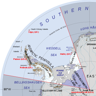
Queen Elizabeth Land is a portion of mainland Antarctica named by the government of the United Kingdom and claimed as part of the British Antarctic Territory. Situated south of Weddell Sea and between longitudes 20°W and 80°W, stretching from Filchner-Ronne Ice Shelf to the South Pole. It is bordered by Zumberge Coast of Ellsworth Land to the West and by Hercules Inlet to the Northwest. To the Northeast, circle of latitude 82°S is the dividing line against Coats Land. The area of Queen Elizabeth Land was unnamed until 2012, though most of it was unofficially known as Edith Ronne Land in 1947–68 and includes areas claimed by the United Kingdom, Chile and Argentina.

The Princess Caroline-Mathilde Alps are a mountain range system in the Holm Land Peninsula, King Frederick VIII Land, northeastern Greenland. Administratively this range is part of the Northeast Greenland National Park zone.
The Princess Elizabeth Alps is a mountain range in King Frederick VIII Land, northeastern Greenland. Administratively this range is part of the Northeast Greenland National Park zone.