
Following is a list of glaciers of the Ross Dependency in Antarctica. There are a great many glaciers in the Ross Dependency, not all of which have been named. This list may not reflects recent namings.
Following is a list of glaciers of the Ross Dependency in Antarctica. There are a great many glaciers in the Ross Dependency, not all of which have been named. This list may not reflects recent namings.
King Edward VII Land is a peninsula in the Ross Dependency.

The Ross Dependency is a region of Antarctica defined by a sector originating at the South Pole, passing along longitudes 160° east to 150° west, and terminating at latitude 60° south. It is claimed by New Zealand, a claim accepted only by the other six countries with territorial claims in Antarctica. Under the 1961 Antarctic Treaty, of which all territorial claimants are signatories, including New Zealand, all claims are held in abeyance. Article IV states: "No acts or activities taking place while the present Treaty is in force shall constitute a basis for asserting, supporting or denying a claim to territorial sovereignty in Antarctica or create any rights of sovereignty in Antarctica".

The Ross Sea is a deep bay of the Southern Ocean in Antarctica, between Victoria Land and Marie Byrd Land and within the Ross Embayment, and is the southernmost sea on Earth. It derives its name from the British explorer James Clark Ross who visited this area in 1841. To the west of the sea lies Ross Island and Victoria Land, to the east Roosevelt Island and Edward VII Peninsula in Marie Byrd Land, while the southernmost part is covered by the Ross Ice Shelf, and is about 200 miles (320 km) from the South Pole. Its boundaries and area have been defined by the New Zealand National Institute of Water and Atmospheric Research as having an area of 637,000 square kilometres (246,000 sq mi).

Ross Island is an island in Antarctica lying on the east side of McMurdo Sound and extending 43 nautical miles from Cape Bird on the north to Cape Armitage on the south, and a like distance from Cape Royds on the west to Cape Crozier on the east. The island is entirely volcanic. Mount Erebus, 3,795 metres (12,451 ft), near the center, is an active volcano. Mount Terror, 3,230 metres (10,600 ft), about 20 nautical miles eastward, is an extinct volcano. Mount Bird rises to 1,765 metres (5,791 ft) just south of Cape Bird. Ross Island lies within the boundary of Ross Dependency, an area of Antarctica claimed by New Zealand.
The Transantarctic Mountains comprise a mountain range of uplifted rock in Antarctica which extends, with some interruptions, across the continent from Cape Adare in northern Victoria Land to Coats Land. These mountains divide East Antarctica and West Antarctica. They include a number of separately named mountain groups, which are often again subdivided into smaller ranges.
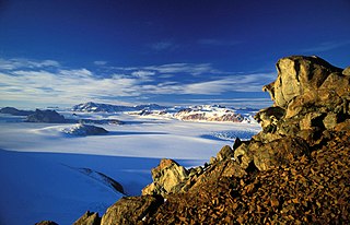
Skelton Glacier is a large glacier flowing from the polar plateau into the Ross Ice Shelf at Skelton Inlet on the Hillary Coast, south of Victoria Land, Antarctica.
This is a timeline of the history of New Zealand's involvement with Antarctica.
The Queen Maud Mountains are a major group of mountains, ranges and subordinate features of the Transantarctic Mountains, lying between the Beardmore and Reedy Glaciers and including the area from the head of the Ross Ice Shelf to the Antarctic Plateau in Antarctica. Captain Roald Amundsen and his South Pole party ascended Axel Heiberg Glacier near the central part of this group in November 1911, naming these mountains for the Norwegian queen Maud of Wales.

The Darwin Glacier is a large glacier in Antarctica. It flows from the polar plateau eastward between the Darwin Mountains and the Cook Mountains to the Ross Ice Shelf. The Darwin and its major tributary the Hatherton are often treated as one system, the Darwin–Hatherton.

The Royal Society Range is a mountain range in Victoria Land, Antarctica. With its summit at 4,025 metres (13,205 ft), the massive Mount Lister forms the highest point in this range. Mount Lister is located along the western shore of McMurdo Sound between the Koettlitz, Skelton and Ferrar glaciers. Other notable local terrain features include Allison Glacier, which descends from the west slopes of the Royal Society Range into Skelton Glacier.
Ramsey may refer to:
Martin Glacier is a glacier, 3 nautical miles (6 km) wide and 9 nautical miles (17 km) long, which flows west and then northwest from the south side of Mount Lupa to the southeast corner of Rymill Bay where it joins Bertrand Ice Piedmont, on the west coast of Graham Land, Antarctica. It was first surveyed in 1936 by the British Graham Land Expedition (BGLE) under John Riddoch Rymill, and was resurveyed in 1948–1949 by the Falkland Islands Dependencies Survey. The glacier was named for James Hamilton Martin, a member of the British Australian and New Zealand Antarctic Research Expedition (1929–1931) under Sir Douglas Mawson, and first mate of the Penola during the BGLE.
Lennox-King Glacier is a large valley glacier, about 40 nautical miles (70 km) long that flows east into the Ross Ice Shelf.
Alberts Glacier is a heavily crevassed glacier in Antarctica. It is about 8 miles (13 km) long, and flows east from Avery Plateau, Graham Land, until entering Mill Inlet between Balch Glacier and Southard Promontory.
The Mulock Glacier is a large, heavily crevassed glacier which flows into the Ross Ice Shelf 40 kilometers south of the Skelton Glacier in the Ross Dependency, Antarctica.

Flask Glacier, is a gently-sloping glacier, 25 nautical miles long, flowing east from Bruce Plateau to enter Scar Inlet between Daggoo Peak and Spouter Peak in Graham Land, Antarctica. The lower reaches of this glacier were surveyed and photographed by the Falklands Islands Dependencies Survey (FIDS) in 1947. The entire glacier was photographed by the Falkland Islands and Dependencies Aerial Survey Expedition in 1955–56, and mapped by the FIDS in 1957. It was named by the UK Antarctic Place-names Committee after the third mate on the Pequod in Herman Melville's Moby-Dick; or, The White Whale.
Tumble Glacier is a glacier extending along the east side of Alexander Island, Antarctica, 7 nautical miles (13 km) long and 3 nautical miles (6 km) wide, which flows east from the cliffs of Mount Egbert, Mount Ethelwulf and Mount Ethelred of the Douglas Range into the west side of the George VI Ice Shelf that occupies George VI Sound immediately south of Mount King. The glacier was first roughly surveyed in 1936 by the British Graham Land Expedition under Rymill. Resurveyed in 1948 by the Falkland Islands Dependencies Survey, and so named by them because of the extremely broken condition of the lower reaches of the glacier.

Howarth Glacier is a small glacier flowing south-southeast to Admiralty Sound along the west side of The Watchtower, in southeastern James Ross Island, Antarctica. It was named by the UK Antarctic Place-Names Committee in 1995 after Michael Kingsley Howarth, Deputy Keeper of Paleontology at the British Museum, 1980–92, and author of the Falkland Islands Dependencies Survey Scientific Report Number 21, Alexander Island.
Robb Glacier is a glacier about 40 nautical miles (70 km) long that flows through the Ross Dependency to enter the west coast of the Ross Ice Shelf in Antarctica.
Ball Glacier is a small glacier separating Redshaw Point from Hamilton Point, flowing north-east to Markham Bay on the south-east side of James Ross Island. It was named by the UK Antarctic Place-names Committee in 1995 after H. William Ball, Keeper of Paleontology, British Museum, 1966–86, and author of Falklands Islands Dependencies Survey Scientific Report No. 24 on fossils from the James Ross Island area. The region has a low frequency of winds mainly due to the orography of the Antarctic peninsula which affects airflow throughout the region along the eastern coast of the Antarctic Peninsula. The region is moderated by cold air masses passing through the area. They are of continental origins, coming mainly from the south and southwest but can be significantly reduced by the island's advection of oceanic air masses.
Clarke Glacier is a 2 miles (3.2 km)-wide, 20 miles (32 km)-long glacier, located on the west coast of Graham Land in Antarctica. It flows west, along the north side of Sickle Mountain and the Baudin Peaks, to Mikkelsen Bay.