
Following is a list of glaciers of Mac. Robertson Land in Antarctica. This list may not reflect recently named glaciers in Mac. Robertson Land.
Following is a list of glaciers of Mac. Robertson Land in Antarctica. This list may not reflect recently named glaciers in Mac. Robertson Land.
Smith may refer to:

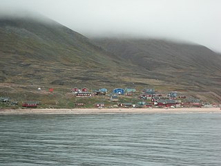
Tongue is a coastal village in northwest Highland, Scotland, in the western part of the former county of Sutherland. It lies on the east shore above the base of the Kyle of Tongue and north of the mountains Ben Hope and Ben Loyal on the A836. To the north lies the area of Braetongue.

A nunatak is the summit or ridge of a mountain that protrudes from an ice field or glacier that otherwise covers most of the mountain or ridge. They often form natural pyramidal peaks. Isolated nunataks are also called glacial islands, and smaller nunataks rounded by glacial action may be referred to as rognons.
Bowers Mountains is a group of north–south trending mountains in Antarctica, about 145 km (90 mi) long and 56 km (35 mi) wide, bounded by the coast on the north and by the Rennick, Canham, Black and Lillie glaciers in other quadrants. The seaward end was first sighted in February 1911 from the Terra Nova, under Lt. Harry L.L. Pennell, RN, and was subsequently named "Bowers Hills" in honour of Henry Robertson Bowers who perished with Captain Robert Falcon Scott on their return from the South Pole in 1912. The mountain range is one of the most extensive topographical features within Victoria Land.

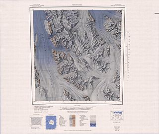
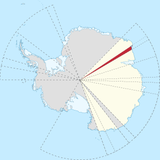
Mac. Robertson Land is the portion of Antarctica lying southward of the coast between William Scoresby Bay and Cape Darnley. It is located at 70°00′S65°00′E. In the east, Mac. Robertson Land includes the Prince Charles Mountains. It was named by the British Australian and New Zealand Antarctic Research Expedition (BANZARE) (1929–1931), under Sir Douglas Mawson, after Sir Macpherson Robertson of Melbourne, a patron of the expedition.
Mount Menzies is the culminating peak on the large massif between Mount Mather and Mount Bayliss, standing on the south side of Fisher Glacier, Antarctica. It was sighted by Flying Officer J. Seaton from an ANARE Beaver aircraft in 1956, and mapped by an ANARE southern seismic party under K.B. Mather in 1957–58. Mount Menzies was named by ANCA after the Rt. Hon. Robert Menzies, Prime Minister of Australia, 1939–41 and 1949–66.
Kemp Land is a thin sliver of Antarctica including, and lying inland from, the Kemp Coast. Part of the Australian Antarctic claim, it is defined as lying between 56° 25' E and 59° 34' E, and, as with other sectors of the Antarctic, is deemed being limited by the 60° S parallel. It is bounded in the east by Mac. Robertson Land and in the west by Enderby Land. Kemp Land includes one major group of islands, the Øygarden Group.
Bindschadler Ice Stream is an ice stream between Siple Dome and MacAyeal Ice Stream. It is one of several major ice streams draining from Marie Byrd Land into the Ross Ice Shelf. The ice streams were investigated and mapped by U.S. Antarctic Research Program personnel in a number of field seasons from 1983 to 1984 and named Ice Stream A, B, C, etc., according to their position from south to north.
The Echelmeyer Ice Stream, formerly known as Ice Stream F, is a glaciological feature of the West Antarctic Ice Sheet. It is an ice stream flowing west to the Shirase Coast to the north of the MacAyeal Ice Stream, and is one of several major ice streams draining from Marie Byrd Land into the Ross Ice Shelf. The ice streams were investigated and mapped by U.S. Antarctic Research Program personnel in a number of field seasons from 1983–84 and originally named Ice Stream A, B, C, etc., according to their position from south to north.
MacAyeal Ice Stream, formerly Ice Stream E, is an ice stream in Antarctica flowing west to the juncture of Shirase Coast and Siple Coast between Bindschadler Ice Stream and Echelmeyer Ice Stream. It is one of several major ice streams draining from Marie Byrd Land into the Ross Ice Shelf. The ice streams were investigated and mapped by U.S. Antarctic Research Program personnel in a number of field seasons from 1983 to 1984 onwards and named Ice Stream A, B, C, etc., according to their position from south to north. The name was changed from Ice Stream E by the Advisory Committee on Antarctic Names in 2002 to honor Douglas R. MacAyeal of the Department of Geophysical Sciences, University of Chicago, a U.S. Antarctic Program investigator in the Ross Sea area including study of the Ross Ice Shelf, the West Antarctic Ice Sheet and the Marie Byrd Land ice streams, 1989–2002. Shabtaie Ice Ridge sits between the MacAyeal and Bundschadler ice streams.
Cape Bruce forms the northern tip of a small island lying at the eastern side of Oom Bay, separated from the mainland rocks just west of Taylor Glacier in Mac. Robertson Land, Antarctica.
Radok Lake is a meltwater lake about four miles (6.4 km) long and marked by a slender glacier tongue feeding into it from the west, lying three miles (4.8 km) south-west of Beaver Lake and 15 miles (24 km) south-east of the Aramis Range, Prince Charles Mountains. It was plotted by Australian National Antarctic Research Expeditions (ANARE) from air photos taken by the RAAF Antarctic Flight in 1956. The lake was named for Uwe Radok, Reader (head) of Meteorology Department at the University of Melbourne, who greatly assisted Australian National Antarctic Research Expeditions (ANARE)'s glaciological program. With a depth of 362 metres (1,188 ft), Radok Lake is the deepest known lake on the Antarctic continent and the only known freshwater lake to host a floating ice tongue glacier. It is drained by three-mile-long (4.8 km) Pagodroma Gorge in to Beaver Lake. Radok Lake is an isothermal and non-stratified Lake, i.e. homogeneous water body.
Gaussiran Glacier is a glacier in the eastern part of the Britannia Range, Antarctica. It drains north from the saddle with Merrick Glacier to a juncture with Darwin Glacier between the Cranfield Icefalls and the Nebraska Peaks. It is separated from Alley Glacier by a series of large rock buttresses, including Robertson Buttress.
MacNamara Glacier is a glacier in the Patuxent Range of the Pensacola Mountains in Antarctica, draining northeastward between the Thomas Hills and Anderson Hills to Foundation Ice Stream. It was mapped by the United States Geological Survey from surveys and U.S. Navy air photos, 1956–66, and was named by the Advisory Committee on Antarctic Names for Edlen E. MacNamara, a United States Antarctic Research Program exchange scientist at Molodezhnaya Station, winter 1967.
Scoble Glacier is a glacier 4 nautical miles (7 km) west of Campbell Head in Mac. Robertson Land. Mapped by Norwegian cartographers from air photos taken by the Lars Christensen Expedition, 1936–37, and named Breoddane. Renamed by Antarctic Names Committee of Australia (ANCA) for Charles H. Scoble, diesel engineer at Macquarie Island station, who drowned in July 1948.
Forbes Glacier may refer to:

Taylor Rookery is an emperor penguin breeding colony on the Mawson Coast of Mac. Robertson Land in East Antarctica. It is the larger of the two known entirely land-based colonies of the species, most of which are situated on sea ice.
MacCormick Fjord is a fjord in northern Greenland. To the southwest, the fjord opens into the Murchison Sound of the Baffin Bay.
Siorapaluup Kangerlua, also known as Robertson Fjord and Robertson Bay, is a fjord in northern Greenland. To the southwest, the fjord opens into the Murchison Sound of the Baffin Bay. Administratively it belongs to the Avannaata municipality.