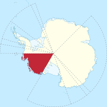
Marie Byrd Land (MBL) is an unclaimed region of Antarctica. With an area of 1,610,000 km2 (620,000 sq mi), it is the largest unclaimed territory on Earth. It was named after the wife of American naval officer Richard E. Byrd, who explored the region in the early 20th century.

The Byrd Glacier is a major glacier in Antarctica, about 136 km (85 mi) long and 24 km (15 mi) wide. It drains an extensive area of the Antarctic plateau, and flows eastward to discharge into the Ross Ice Shelf.

Hammond Glacier is located on the northeast side of the Haines Mountains, flowing northwest for about 40 nautical miles (70 km) to Sulzberger Ice Shelf in the Ford Ranges of Marie Byrd Land, Antarctica. It was discovered in 1934 by the Byrd Antarctic Expedition, and named by Richard E. Byrd for John Hays Hammond, an American mining engineer and philanthropist.

The Fosdick Mountains are an east–west trending mountain range with marked serrate outlines, standing along the south side of Balchen Glacier at the head of Block Bay, in the Ford Ranges of Marie Byrd Land, Antarctica. They were discovered by the Byrd Antarctic Expedition in 1929, and named by Richard E. Byrd for Raymond B. Fosdick, who became president of the Rockefeller Foundation.
The Ford Ranges are a grouping of mountain ranges standing east of Sulzberger Ice Shelf and Block Bay in the northwest part of Marie Byrd Land, Antarctica. Discovered by the Byrd Antarctic Expedition on December 5, 1929, they were named by Byrd for Edsel Ford of the Ford Motor Company, who helped finance the expedition.
Crevasse Valley Glacier is a broad glacier about 30 miles (50 km) long, flowing west-southwest between the Chester Mountains and the Saunders Mountain to the Sulzberger Ice Shelf in Marie Byrd Land, Antarctica. It was discovered by a sledging party of the Byrd Antarctic Expedition, which visited this area in November–December 1934, and so named because of its extensively crevassed surface.

The Billboard is a massive granite monolith in the Sarnoff Mountains of the Ford Ranges of Marie Byrd Land, West Antarctica, standing just west of Mount Rea between Arthur Glacier and Boyd Glacier. It was discovered in November 1934 by a Second Byrd Antarctic Expedition (1933–35) sledge party under Paul Siple, and is so named because of its form and appearance with vertical faces rising above the continental ice.
Mount Rea ; Sarnoff Mountains, Ford Ranges, Marie Byrd Land, Antarctica. A prominent mountain with an imposing monolith on its west side called the Billboard, standing between Arthur Glacier and Boyd Glacier. It is composed of Byrd Coast granite of Cretaceous age, and reaches an elevation of 760 m. It was discovered by the Byrd Antarctic Expedition on the Eastern Flight of December 5, 1929, and named by Byrd for Mr. and Mrs. Rea, of Pittsburgh, Pennsylvania, contributors to the expedition.

The Byrd Station is a former research station established by the United States during the International Geophysical Year by U.S. Navy Seabees during Operation Deep Freeze II in West Antarctica.
Mount Iphigene ; a mountain just west of Ochs Glacier between Marujupu Peak and Birchall Peaks, in the Fosdick Mountains, Ford Ranges, Marie Byrd Land, Antarctica. It is composed of Fosdick Metamorphic Rocks migmatite and granite of Cretaceous age. Its peak elevation is estimated at 1080 m. Discovered in 1929 by the Byrd Antarctic Expedition, they are named by Byrd for Iphigene Ochs Sulzberger, daughter of Adolph Ochs and wife of Arthur Sulzberger, patrons of the expedition.
The Land Glacier is a broad, heavily crevassed glacier, about 35 nautical miles (60 km) long, descending into Land Bay in Marie Byrd Land, Antarctica. It was discovered by the U.S. Antarctic Service (1939–41) and named for Rear Admiral Emory S. Land, Chairman of the U.S. Maritime Commission.
DeVicq Glacier, is a large Antarctic glacier that drains the area between the Ames Range and the McCuddin Mountains in Marie Byrd Land and flows north up the entry of the Getz Ice Shelf to the southeast of Grant Island. It was mapped by the U.S. Geological Survey from surveys and U.S. Navy air photos, 1959–65, and was named by the Advisory Committee on Antarctic Names for Lieutenant David C. DeVicq, U.S. Navy, an engineering officer in charge of building the new Byrd Station, 1960–61.
Berry Glacier is an Antarctic glacier, about 25 miles (40 km) long and 5 miles (8 km) wide, draining north between Perry Range and Demas Range into the Getz Ice Shelf on the coast of Marie Byrd Land. This vicinity was first photographed and rudely charted from aircraft of the U.S. Antarctic Service in December 1940, and the glacier was mapped in detail by the U.S. Geological Survey from ground surveys and from U.S. Navy air photos, 1959–66. It was named by the Advisory Committee on Antarctic Names for Commander William H. Berry, U.S. Navy, Air Operations Officer for Task Force 43 during Operation Deep Freeze 1969–72; Operations Officer, 1973.
Arthur Glacier is a valley glacier in Antarctica. It is about 25 nautical miles (50 km) long, and flows west to Sulzberger Ice Shelf between the Swanson Mountains on the north and Mount Rea and Mount Cooper on the south, in the Ford Ranges of Marie Byrd Land. It was discovered by members of West Base of the United States Antarctic Service, in aerial flights and from ground surveys in November–December 1940. It was named by the Advisory Committee on Antarctic Names for Rear Admiral Arthur C. Davis, a leader in aviation in the U.S. Navy.
Balchen Glacier is a crevassed glacier in Antarctica, flowing west to Block Bay between the Phillips Mountains and the Fosdick Mountains in Marie Byrd Land. It was discovered on December 5, 1929, by the Byrd Antarctic Expedition and named by Richard E. Byrd for Bernt Balchen, chief pilot of the expedition.
White Glacier is a broad westward flowing tributary glacier which joins the Land Glacier on the north side of Mount McCoy in Marie Byrd Land. Mapped by United States Geological Survey (USGS) from surveys and U.S. Navy air photos, 1959–65. Named by Advisory Committee on Antarctic Names (US-ACAN) for General Thomas D. White, United States Air Force (USAF), Chief of Staff and member of the Joint Chiefs of Staff, 1957–61, who participated in the planning and organizational stages of Operation Deep Freeze in an administrative capacity and in matters relating to aircraft. Application of the name was proposed by Admiral Richard E. Byrd.
Paschal Glacier is a glacier about 20 nautical miles (37 km) long and 4 nautical miles (7 km) wide, draining northwest between two ridges, the terminal points of which are Mount McCoy and Lewis Bluff. The lower end of this glacier merges with the flow of White Glacier and the larger Land Glacier near Mount McCoy before the latter feature debouches into Land Bay on the coast of Marie Byrd Land. Paschal Glacier was photographed from aircraft of the United States Antarctic Service (USAS), 1939–41, and was mapped by United States Geological Survey (USGS) from surveys and U.S. Navy aerial photography, 1959–65. Named by Advisory Committee on Antarctic Names (US-ACAN) for Evans W. Paschal, Scientific Leader at Byrd Station, 1970.
McClinton Glacier is a glacier between the base of Martin Peninsula and the Jenkins Heights, flowing east-northeast into the Dotson Ice Shelf, on the Walgreen Coast of Marie Byrd Land, Antarctica. It was mapped by the United States Geological Survey from surveys and U.S. Navy aerial photographs, 1959–67, and was named by the Advisory Committee on Antarctic Names after Racie A. McClinton, Jr., U.S. Navy, an LC-130 flight engineer of Squadron VXE-6, who served in nine Operation Deep Freeze deployments through to 1977.

Warpasgiljo Glacier is a valley glacier about 25 mi (40 km) long, flowing West to Sulzberger Ice Shelf between the Swanson Mountains on the North and Mounts Rea and Cooper on the South, in the Edsel Ford Ranges of Marie Byrd Land. This glacier was discovered by and named for the four Geological Party Expedition members of the West Base of the United States Antarctic Service (USAS), in aerial flights and from ground surveys in November–December 1940, as part of the Antarctic Expedition of 1939-1941 led by Rear Admiral Richard E. Byrd.