Following is a list of glaciers of Victoria Land in Antarctica. This list may not reflect recently named glaciers in Victoria Land.

Following is a list of glaciers of Victoria Land in Antarctica. This list may not reflect recently named glaciers in Victoria Land.

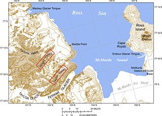
The McMurdo Dry Valleys are a row of largely snow-free valleys in Antarctica, located within Victoria Land west of McMurdo Sound. The Dry Valleys experience extremely low humidity and surrounding mountains prevent the flow of ice from nearby glaciers. The rocks here are granites and gneisses, and glacial tills dot this bedrock landscape, with loose gravel covering the ground. It is one of the driest places on Earth and is sometimes claimed to have not seen rain in nearly two million years, though this is highly unlikely and several anecdotal accounts of rainfall within the Dry Valleys exist.
Skelton Glacier is a large glacier flowing from the polar plateau into the Ross Ice Shelf at Skelton Inlet on the Hillary Coast, south of Victoria Land, Antarctica.

The Darwin Glacier is a large glacier in Antarctica. It flows from the polar plateau eastward between the Darwin Mountains and the Cook Mountains to the Ross Ice Shelf. The Darwin and its major tributary the Hatherton are often treated as one system, the Darwin–Hatherton.
Lillie Glacier is a large glacier in Antarctica, about 100 nautical miles long and 10 nautical miles wide. It lies between the Bowers Mountains on the west and the Concord Mountains and Anare Mountains on the east, flowing to Ob' Bay on the coast and forming the Lillie Glacier Tongue.

Bowers Mountains is a group of north–south trending mountains in Antarctica, about 145 km (90 mi) long and 56 km (35 mi) wide, bounded by the coast on the north and by the Rennick, Canham, Black and Lillie glaciers in other quadrants. The seaward end was first sighted in February 1911 from the Terra Nova, under Lt. Harry L.L. Pennell, RN, and was subsequently named "Bowers Hills" in honour of Henry Robertson Bowers who perished with Captain Robert Falcon Scott on their return from the South Pole in 1912. The mountain range is one of the most extensive topographical features within Victoria Land.

Koettlitz Glacier is a large Antarctic glacier lying west of Mount Morning and Mount Discovery in the Royal Society Range, flowing from the vicinity of Mount Cocks northeastward between Brown Peninsula and the mainland into the ice shelf of McMurdo Sound.
The Aviator Glacier is a major valley glacier in Antarctica that is over 60 nautical miles long and 5 nautical miles wide, descending generally southward from the plateau of Victoria Land along the west side of Mountaineer Range, and entering Lady Newnes Bay between Cape Sibbald and Hayes Head where it forms a floating tongue.

The Asgard Range is a mountain range in Victoria Land, Antarctica. It divides Wright Valley from Taylor Glacier and Taylor Valley. It was named by the Victoria University of Wellington Antarctic Expedition (1958–59) after Asgard, the home of the Norse gods.

The David Glacier is a glacier over 60 nautical miles long, flowing east from the polar plateau through the Prince Albert Mountains to the coast of Victoria Land, Antarctica. It enters Ross Sea between Cape Philippi and Cape Reynolds to form the floating Drygalski Ice Tongue. It is the most imposing outlet glacier in Victoria Land. It is fed by two main flows which drain an area larger than 200,000 square kilometres, with an estimated ice discharge rate of 7.8 +/- 0.7 km³/year. The David Glacier was discovered by Ernest Shackleton's "Northern Party," in November 1908, under the leadership of Prof. T.W. Edgeworth David, of Sydney University, for whom the feature was named.
The Mariner Glacier is a major glacier over 60 nautical miles long, descending southeast from the plateau of Victoria Land, Antarctica, between Mountaineer Range and Malta Plateau, and terminating at Lady Newnes Bay, Ross Sea, where it forms the floating Mariner Glacier Tongue.
Lady Newnes Bay is a bay about 60 nautical miles long in the western Ross Sea, extending along the coast of Victoria Land from Cape Sibbald to Coulman Island.

The Adare Peninsula, is a high ice-covered peninsula, 40 nautical miles long, in the northeast part of Victoria Land, extending south from Cape Adare to Cape Roget. The peninsula was named by the New Zealand Antarctic Place-Names Committee (NZ-APC) for Cape Adare. The peninsula is considered the southernmost point of the Borchgrevink Coast, named for Carsten Borchgrevink (1864-1934).
Falkner Glacier, is an east-flowing valley glacier, 4 nautical miles long, located 2 nautical miles south of Oakley Glacier in the Mountaineer Range, Victoria Land, Antarctica. The glacier descends steeply to Lady Newnes Bay where it forms a floating glacier tongue. It was named by the Advisory Committee on Antarctic Names (2008) after Kelly K. Falkner, Professor of Chemical Oceanography at Oregon State University, who served from 2006 as the first Program Director for the Antarctic Integrated System Science Program in the Division of Antarctic Sciences, Office of Antarctic Programs, National Science Foundation.
Rennick Glacier is broad glacier, nearly 200 nautical miles long, which is one of the largest in Antarctica. It rises on the polar plateau westward of Mesa Range and is 20 to 30 nautical miles wide, narrowing to 10 nautical miles near the coast. It takes its name from Rennick Bay where the glacier reaches the sea.

Wilson Piedmont Glacier is a large piedmont glacier extending from Granite Harbour to Marble Point on the coast of Victoria Land.

Wright Upper Glacier is an ice apron at the upper west end of Wright Valley in the Asgard Range, Antarctica. It is formed by a glacier flowing east from the inland ice plateau. It was named by the Victoria University of Wellington Antarctic Expedition (VUWAE) (1958–59) for C. S. Wright, a member of the British Antarctic Expedition (1910–13), after whom the "Wright Glacier" was named.
Barber Glacier is a glacier rising just east of Mount Bruce in the Bowers Mountains and flowing north to the coast between Stuhlinger Ice Piedmont and Rosenau Head, Victoria Land, Antarctica. The glacier was mapped by the United States Geological Survey from surveys and from U.S. Navy air photos, 1960–65, and named by the Advisory Committee on Antarctic Names for Captain Don W. Barber, CE, USA, construction and equipment officer, U.S. Naval Support Force, Antarctica, 1967 and 1968. The glacier lies on the Pennell Coast, a portion of Antarctica lying between Cape Williams and Cape Adare.
Evans Piedmont Glacier is a broad ice sheet occupying the low-lying coastal platform between Tripp Island and Cape Archer in Victoria Land, Antarctica.
Moubray Bay is a bay in the western Ross Sea, indenting the coast of Victoria Land, Antarctica, between Cape Roget and Cape Hallett. It was discovered in 1841 by Sir James Clark Ross and named by him for George H. Moubray, clerk in charge of the expedition ship Terror.
The Mawson Glacier is a large glacier on the east coast of Victoria Land, Antarctica, descending eastward from the Antarctic Plateau to the north of Trinity Nunatak and the Kirkwood Range, to enter the Ross Sea, where it forms the Nordenskjöld Ice Tongue. The glacier was first mapped by the British Antarctic Expedition (1907–09) and named for Douglas Mawson, the expedition physicist, who later led two other Antarctic expeditions, 1911–14, and 1929–31.