The McMurdo Dry Valleys are a row of largely snow-free valleys in Antarctica, located within Victoria Land west of McMurdo Sound. The Dry Valleys experience extremely low humidity and surrounding mountains prevent the flow of ice from nearby glaciers. The rocks here are granites and gneisses, and glacial tills dot this bedrock landscape, with loose gravel covering the ground. It is one of the driest places on Earth and is sometimes claimed to have not seen rain in nearly two million years, though this is highly unlikely and several anecdotal accounts of rainfall within the Dry Valleys exist.

Lake Fryxell is a frozen lake 4.5 kilometres (2.8 mi) long, between Canada Glacier and Commonwealth Glaciers at the lower end of Taylor Valley in Victoria Land, Antarctica. It was mapped in the early 1900s and named during Operation Deep Freeze in the 1950s. There are several forms of algae living in the waters and a weather station located at the lake.

Koettlitz Glacier is a large Antarctic glacier lying west of Mount Morning and Mount Discovery in the Royal Society Range, flowing from the vicinity of Mount Cocks northeastward between Brown Peninsula and the mainland into the ice shelf of McMurdo Sound.

The Wright Valley, named after Sir Charles Wright, is the central one of the three large Dry Valleys in the Transantarctic Mountains, located west of McMurdo Sound at approximately 77°10′S161°50′E. Wright Valley contains the Onyx River, the longest river in Antarctica, Lake Brownworth, the origin of the Onyx River, and Lake Vanda, which is fed by the Onyx River. Its southwestern branch, South Fork, is the location of Don Juan Pond. The upland area known as the Labyrinth is at the valley's west end.

Cape Evans is a rocky cape on the west side of Ross Island, Antarctica, forming the north side of the entrance to Erebus Bay.

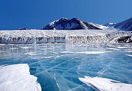
Lake Bonney is a saline lake with permanent ice cover at the western end of Taylor Valley in the McMurdo Dry Valleys of Victoria Land, Antarctica.
Ablation Valley, also known as Ablation Bay, is a mainly ice-free valley on the east coast of Alexander Island, 3 km (1.9 mi) long, which is entered immediately south of Ablation Point, opens on George VI Sound and lies immediately north of Ganymede Heights. It was first photographed from the air on 23 November 1935 by Lincoln Ellsworth and mapped from these photographs by W.L.G. Joerg. It was first visited and surveyed in 1936 by the British Graham Land Expedition (BGLE), and given the name "Ablation" by them because of the relatively small amounts of snow and ice found there. The site lies within Antarctic Specially Protected Area (ASPA) No.147.
Taylor Valley is the southernmost of the three large McMurdo Dry Valleys in the Transantarctic Mountains, Victoria Land, Antarctica, located west of McMurdo Sound at approximately 77°37′S163°00′E. The valley extends from Taylor Glacier in the west to McMurdo Sound at Explorers Cove at the northwest head of New Harbour in the east and is about 29 kilometres (18 mi) long. It was once occupied by the receding Taylor Glacier, from which it derives its name. Taylor Valley contains Lake Bonney in the west (inward), and Lake Fryxell in the east (coastward), and Lake Hoare, Lake Chad, Lake Popplewell, Mummy Pond and Parera Pond close together between the two. Further east of Lake Bonney is Pearse Valley. Taylor Valley is separated from Wright Valley in the north by Asgard Range, and from Ferrar Glacier in the south by Kukri Hills.

Wilson Piedmont Glacier is a large piedmont glacier extending from Granite Harbour to Marble Point on the coast of Victoria Land.
Andersen Creek is a meltwater stream, 1.5 kilometres (0.9 mi) long, flowing southwest along the east side of Canada Glacier into the northeast corner of Lake Hoare in Taylor Valley, Victoria Land, Antarctica.
Balham Valley is an ice-free valley between the Insel Range and the Apocalypse Peaks, in Victoria Land, Antarctica. It was named by the Victoria University of Wellington Antarctic Expedition (1958–59) for R.W. Balham, biologist with the New Zealand party of the Commonwealth Trans-Antarctic Expedition who did the first freshwater biology in this area in 1957–58.
Barwick Valley is an ice-free valley north of Apocalypse Peaks, extending from Webb Glacier to Victoria Valley in Victoria Land, Antarctica. It was named by the Victoria University of Wellington Antarctic Expedition (VUWAE) (1958–59) for R.E. Barwick, summer biologist with the New Zealand party of the Commonwealth Trans-Antarctic Expedition (1956–58) who worked in this area in 1957–58 and as a member of the VUWAE, 1958–59.
Canada Stream is a small meltwater stream flowing east-southeast from the front of Canada Glacier into Lake Fryxell, in Taylor Valley, Victoria Land, Antarctica. It was named in association with Canada Glacier by the New Zealand Antarctic Place-Names Committee in 1983.

Kukri Hills is a prominent east-west trending range, about 25 nautical miles (46 km) long and over 2,000 metres (6,600 ft) high, forming the divide between Ferrar Glacier on the south and Taylor Glacier and Taylor Valley on the north, in Victoria Land, Antarctica.
Granite Harbour is a bay in the coast of Victoria Land, Antarctica, about 14 nautical miles long, entered between Cape Archer and Cape Roberts. It was discovered and named by the British National Antarctic Expedition (BrNAE) of 1901–04 in the Discovery in January 1902, while searching for safe winter quarters for the ship. The name derives from the great granite boulders found on its shores.
Himalia Ridge is a ridge running east–west on the north side of the Ganymede Heights massif, north-east of Jupiter Glacier, in the east of Alexander Island, Antarctica. It was photographed from the air by the Ronne Antarctic Research Expedition in 1947 and mapped from these photographs by D. Searle of the Falkland Islands Dependencies Survey in 1960. The ridge was named by the UK Antarctic Place-Names Committee following British Antarctic Survey geological work, 1983–84, after Himalia, a satellite of the planet Jupiter, in association with Jupiter Glacier.
Mount Torii is a prominent bluff-type mountain above Lake Chad and Lake Hoare, surmounting the north wall of Taylor Valley between Suess Glacier and Canada Glacier, in Victoria Land. Named by Advisory Committee on Antarctic Names (US-ACAN) (1997) after Tetsuya Torii, geochemist, Japan Polar Research Association, who led Japanese research parties in geochemical studies of the lakes and ponds of McMurdo Dry Valleys in 20 summer field seasons, 1963 though 1986–87.
Mount Keohane is a peak immediately northwest of Lake Fryxell, rising to 1,250 metres (4,100 ft) between Canada Glacier and Huey Gully on the north side of Taylor Valley, in Victoria Land, Antarctica. It was named in 1997 by the Advisory Committee on Antarctic Names after Petty Officer Patrick Keohane, Royal Navy, of the British Antarctic Expedition, 1910–13. Keohane was a member of Robert F. Scott's South Pole journey support party that reached the Upper Glacier Depot on Beardmore Glacier before returning to headquarters on Cape Evans.

The Ablation Point – Ganymede Heights Antarctic Specially Protected Area is a 180 km2 mountainous tract of land on the eastern side of Alexander Island in the Bellinghausen Sea, west of Palmer Land on the Antarctic Peninsula. It has been designated Antarctic Specially Protected Area (ASPA) No.147 for its geological, geomorphological, glaciological, limnological, and ecological values, and to protect its terrestrial and freshwater ecosystems from uncontrolled human visitation and activity.

Lake Washburn is a lake that formerly existed in the Taylor Valley, McMurdo Dry Valleys, Antarctica. It formed when climatic changes and an expansion of ice caused the flooding of the valley, between 23,000 and 8,340 radiocarbon years ago. Its extent and elevation are unclear but Lake Bonney and Lake Fryxell are considered to be its present-day remnant.