Contents
- List of glaciers
- Saint Elias Mountains
- Coast Mountains
- Vancouver Island Ranges
- Columbia Mountains
- Interior Mountains
- Canadian Rockies (BC/AB)
- Arctic Archipelago
- See also
- References

This is a list of glaciers in Canada .
This is a list of glaciers in Canada .


Yoho National Park is a national park of Canada. It is located within the Rocky Mountains along the western slope of the Continental Divide of the Americas in southeastern British Columbia, bordered by Kootenay National Park to the south and Banff National Park to the east in Alberta. The word Yoho is a Cree expression of amazement or awe, and it is an apt description for the park's spectacular landscape of massive ice fields and mountain peaks, which rank among the highest in the Canadian Rockies.

Banff National Park is Canada's oldest national park, established in 1885 as Rocky Mountains Park. Located in Alberta's Rocky Mountains, 110–180 kilometres (68–112 mi) west of Calgary, Banff encompasses 6,641 square kilometres (2,564 sq mi) of mountainous terrain, with many glaciers and ice fields, dense coniferous forest, and alpine landscapes. Provincial forests and Yoho National Park are neighbours to the west, while Kootenay National Park is located to the south and Kananaskis Country to the southeast. The main commercial centre of the park is the town of Banff, in the Bow River valley.

The Canadian Rocky Mountain Parks World Heritage Site consists of seven contiguous parks including four national parks and three British Columbia provincial parks.

The Canadian Rockies or Canadian Rocky Mountains, comprising both the Alberta Rockies and the British Columbian Rockies, is the Canadian segment of the North American Rocky Mountains. It is the easternmost part of the Canadian Cordillera, which is the northern segment of the North American Cordillera, the expansive system of interconnected mountain ranges between the Interior Plains and the Pacific Coast that runs northwest–southeast from central Alaska to the Isthmus of Tehuantepec in Mexico.

The Columbia Icefield is the largest ice field in North America's Rocky Mountains. Located within the Canadian Rocky Mountains astride the Continental Divide along the border of British Columbia and Alberta, Canada, the ice field lies partly in the northwestern tip of Banff National Park and partly in the southern end of Jasper National Park. It is about 325 square kilometres (125 sq mi) in area, 100 to 365 metres in depth and receives up to 7 metres (280 in) of snowfall per year.

An ice field is a mass of interconnected valley glaciers on a mountain mass with protruding rock ridges or summits. They are often found in the colder climates and higher altitudes of the world where there is sufficient precipitation for them to form. The higher peaks of the underlying mountain rock that protrude through the icefields are known as nunataks. Ice fields are larger than alpine glaciers, but smaller than ice caps and ice sheets. The topography of ice fields is determined by the shape of the surrounding landforms, while ice caps have their own forms overriding underlying shapes.

The Pacific Ranges are the southernmost subdivision of the Coast Mountains portion of the Pacific Cordillera. Located entirely within British Columbia, Canada, they run northwest from the lower stretches of the Fraser River to Bella Coola and Burke Channel, north of which are the Kitimat Ranges. The Coast Mountains lie between the Interior Plateau and the Coast of British Columbia.

The Waddington Range is a subrange of the Pacific Ranges of the Coast Mountains in southwestern British Columbia, Canada. It is only about 4,000 km2 in area, relatively small in area within the expanse of the range, but it is the highest area of the Pacific Ranges and of the Coast Mountains, being crowned by its namesake Mount Waddington 4,019 m (13,186 ft). The Waddington Range is also extremely rugged and more a complex of peaks than a single icefield, in contrast to the other huge icefield-massifs of the southern Coast Mountains, which are not so peak-studded and tend to have more contiguous icemasses.
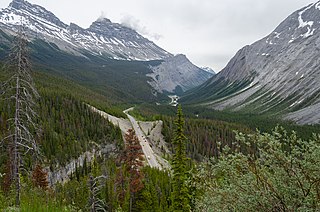
Highway 93 is a north–south highway in Alberta, Canada. It is also known as the Banff-Windermere Parkway south of the Trans-Canada Highway (Highway 1) and the Icefields Parkway north of the Trans-Canada Highway. It travels through Banff National Park and Jasper National Park and is maintained by Parks Canada for its entire length. It runs from the British Columbia border at Vermilion Pass in the south, where it becomes British Columbia Highway 93, to its terminus at the junction with the Yellowhead Highway (Highway 16) at Jasper. The route takes its number from U.S. Route 93, which runs uninterrupted south to central Arizona, and was initially designated as '93' in 1959.

Hamber Provincial Park is a provincial park in British Columbia, Canada, located 130 kilometres (80.7 mi) north of Golden. Straddling the Great Divide on the provincial boundary with Alberta, the park is surrounded on three sides by Jasper National Park and protects the headwaters of the Wood River at Fortress Lake.

Snow Dome is a mountain located on the Continental Divide in the Columbia Icefield, where the boundary of Banff National Park and Jasper National Park meets the border of Alberta and British Columbia in Canada. The summit's elevation is 3,456 m (11,339 ft).

The Waputik Icefield is located on the Continental divide in the Canadian Rocky Mountains, in the provinces of British Columbia and Alberta. It is developed on the heights of the Waputik Range in the Central Main Ranges.

The Wapta Icefield is a series of glaciers located on the Continental Divide in the Waputik Mountains of the Canadian Rockies, in the provinces of British Columbia and Alberta, in Yoho National Park in the Canadian Rockies. The icefield is shared by Banff and Yoho National Parks and numerous outlet glaciers extend from the icefield, including the Vulture, Bow and Peyto Glaciers. Runoff from the icefields and outlet glaciers supply water to both the Kicking Horse and Bow Rivers, as well as numerous streams and lakes.
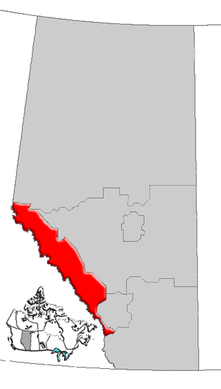
Alberta's Rockies comprise the Canadian Rocky Mountains in Alberta, Canada. On the southwestern part of the province along the British Columbia border, the region covers all but the south of Census Division 15.

The Ha-Iltzuk Icefield is an icefield in the central Pacific Ranges of the Coast Mountains in British Columbia, Canada. It is the largest icefield in the Coast Mountains south of the Alaska Panhandle, with an area of 3,610 km2 (1,390 sq mi). It is located on the west side of the Klinaklini River and the Waddington Range. The highest summit in the icefield is Mount Silverthrone, which is a mountain on the northeast edge of a circular, 20 km (12 mi) wide, deeply dissected caldera complex called the Silverthrone Caldera.
The Lillooet Icecap, also called the Lillooet Icefield or the Lillooet Crown, is a large icefield in the Pacific Ranges of the Coast Mountains in southwestern British Columbia, Canada. It is about 90 km (56 mi) northwest of the towns of Pemberton and Whistler, and about 175 km (109 mi) north of Vancouver, British Columbia. The Lillooet Icecap is one of the largest of several large icefields in the Pacific Ranges which are the largest temperate-latitude glacial fields in the world. At its maximum extent including its glacial tongues it measures 30 km (19 mi) east to west and 20 km (12 mi) north to south; its central icefield area is approximately 15 km (9 mi) in diameter.
The Montane Cordillera Ecozone, as defined by the Commission for Environmental Cooperation (CEC), is an ecozone in south-central British Columbia and southwestern Alberta, Canada. A rugged and mountainous ecozone spanning 473,000 square kilometres, it still contains "two of the few significant agricultural areas of the province", the Creston Valley and the Okanagan Valley. Primarily a mountainous region, it consists of rugged ecosystems such as alpine tundra, dry sagebrush and dense conifer forests. The interior plains are encircled by a ring of mountains. The area has a mild climate throughout the year, with typically dry summers and wet winters.

The Homathko Icefield is an icefield in British Columbia, Canada. Officially named the Homathko Snowfield from 1950 until the current name was adopted in 1976, it is one of the largest icefields in the southern half of the Coast Mountains, with an area of over 2,000 km2 (770 sq mi). It is located between Chilko Lake and the Homathko River, and lies across the Great Canyon of that river to the east of the Waddington Range. Although adjacent to Mount Queen Bess, the Homathko Icefield is largely an expanse of ice, about 30 km (19 mi) across, ringed by relatively minor peaks and distinguished, relative to the other Coast Mountains icefields, by lack of any major ones. The Lillooet Icecap and the Compton Névé, both similar in size to the Homathko Icefield but much more peak-studded, lie to the Homathko Icefield's southeast across the Southgate River which bends around the icefield-massif's southern flank to reach the head of Bute Inlet adjacent to the mouth of the Homathko River. The icefield is essentially one large ice-girt montane plateau between these two rivers.
The Compton Névé is a névé in the Pacific Ranges of the Coast Mountains in southwestern British Columbia, Canada, located southeast of the Homathko Icefield and Mount Gilbert and to the south of the Bishop River. It lies west of the Lillooet Icecap and is connected to it by the Ring Glacier, which sits astride Ring Pass, the divide between the Lillooet and Bishop Rivers, and has an area of 714 km2 (276 sq mi).
The Southgate River is a river in the Pacific Ranges of the Coast Mountains in British Columbia, Canada, entering the head of Bute Inlet, on that province's South Coast, just east of the mouth of the Homathko River at Waddington Harbour. The lower reaches of the river's course are flat-bottomed and are named Pigeon Valley.