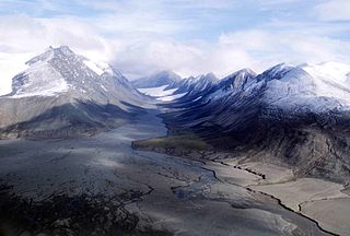
Quttinirpaaq National Park is located on the northeastern corner of Ellesmere Island in the Qikiqtaaluk Region of Nunavut, Canada. It is the second most northerly park on Earth after Northeast Greenland National Park. In Inuktitut, Quttinirpaaq means "top of the world". It was established as Ellesmere Island National Park Reserve in 1988, and the name was changed to Quttinirpaaq in 1999, when Nunavut was created, and became a national park in 2000. The reserve covers 37,775 km2 (14,585 sq mi), making it the second largest park in Canada, after Wood Buffalo National Park.

Axel Heiberg Island is an uninhabited island in the Qikiqtaaluk Region, Nunavut, Canada. Located in the Arctic Ocean, it is the 32nd largest island in the world and Canada's seventh largest island. According to Statistics Canada, it has an area of 43,178 km2 (16,671 sq mi). It is named after Axel Heiberg.

Resolute Bay is an Arctic waterway in the Qikiqtaaluk Region, Nunavut, Canada. It is located in Parry Channel on the southern side of Cornwallis Island. The hamlet of Resolute is located on the northern shore of the bay with Resolute Bay Airport to the northwest. The Inuit associated with Resolute Bay are called Qausuittuq and the population of the hamlet in the 2006 census was 229.

North Kent Island is one of the uninhabited Queen Elizabeth Islands in the Canadian arctic islands in the Qikiqtaaluk Region of Nunavut, Canada. It is located in the Cardigan Strait between Devon Island's Colin Archer Peninsula and Ellesmere Island's Simmons Peninsula.

Auyuittuq National Park is a national park located on Baffin Island's Cumberland Peninsula, in the Qikiqtaaluk Region of Nunavut, the largest political subdivision of Canada. The park was initially known as Baffin Island National Park when it was established in 1972, but the name was changed in 1976 to its current name to better reflect the region and its history. It features many terrains of Arctic wilderness, such as fjords, glaciers, and ice fields. Although Auyuittuq was established in 1972 as a national park reserve, it was upgraded to a full national park in 2000.
Ad astra (phrase) is a Latin phrase meaning "to the stars", and the motto of several organizations

The Baffin Mountains are a mountain range running along the northeastern coast of Baffin Island and Bylot Island, Nunavut, Canada. The ice-capped mountains are part of the Arctic Cordillera and have some of the highest peaks of eastern North America, reaching a height of 1,525–2,146 metres (5,003–7,041 ft) above sea level. While they are separated by bodies of water to make Baffin Island, they are closely related to the other mountain ranges that make the much larger Arctic Cordillera mountain range.
The Victoria and Albert Mountains are a mountain range running on the east coast of Ellesmere Island, Nunavut, Canada. The range is one of the most northern ranges in the world and of the Arctic Cordillera. The highest mountain in the range is Agassiz Ice Cap Summit at 2,201 m (7,221 ft). The range has an area of 37,650 km2 (14,540 sq mi).

The Treuter Mountains, formerly known as the Truter Mountains and the Trenter Mountains, are a small mountain range on eastern Devon Island, Nunavut, Canada. The Treuter Mountains are part of the Devon Ice Cap which forms part of the Arctic Cordillera mountain range.
The Cunningham Mountains are a small mountain range on the southeastern coast of Devon Island, Nunavut, Canada. The Cunningham Mountains are part of the Devon Ice Cap which forms part of the Arctic Cordillera mountain range.
The Penny Ice Cap, formerly Penny Icecap, is a 6,000 km2 (2,300 sq mi) ice cap in Auyuittuq National Park of Baffin Island, Nunavut, Canada. It forms a 2,000 m (6,562 ft) high barrier on the Cumberland Peninsula, an area of deep fjords and glaciated valleys. It is a remnant of the last ice age. During the mid-1990s, Canadian researchers studied the glacier's patterns of freezing and thawing over centuries by drilling ice core samples.

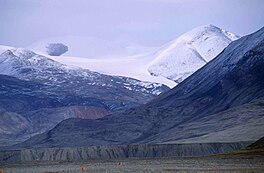
The Conger Range, also called the Conger Mountains, is a mountain range in Quttinirpaaq National Park on Ellesmere Island, Nunavut, Canada, beginning about 16 km (10 mi) west of Mount Osborne. It is part of the Arctic Cordillera which is a vast dissected mountain system extending from Ellesmere Island to the northernmost tip of Labrador and northeastern Quebec. The Conger Range is a structural extension of the Garfield Range and continues into the highlands north of the head of Hare Fiord. The overall extent of the range is about 180 km (112 mi). Most of its peaks are ice-covered, although nearly all of the southern slopes are ice-free. Many of the valleys between the peaks are filled with glacial tongues spilling out to the south from the Grand Land Ice Cap. Its highest point is Mount Biederbick at 1,542 m (5,059 ft).

The Barnes Ice Cap is an ice cap located in central Baffin Island, Nunavut, Canada.
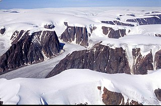
The Devon Ice Cap is an ice cap on eastern Devon Island, Nunavut, Canada, covering an area of over 12,000 km2 (4,600 sq mi). The highest point on Devon Island is found at the summit of the ice cap, with an elevation of 1,921 m (6,302 ft). The ice cap has a maximum thickness of 880 m (2,887 ft), and has been steadily shrinking since 1985.

Coronation Glacier is a glacier on southeastern Baffin Island, Nunavut, Canada. The glacier is on the northeast coast of Cumberland Peninsula and is an outlet glacier of the Penny Ice Cap. The Coronation Glacier lost its connection to the Elena Glacier between 1943 and 1949.

The Agassiz Ice Cap formerly Agassiz Glacier is an ice cap on the central eastern side of Ellesmere Island, Nunavut, Canada. The Agassiz ice cap is about 21,000 km2 (8,100 sq mi) in area. It is located between the North Ellesmere ice field to the north and the Prince of Wales Icefield to the south.
Augusta Bay is a bay of the Ellesmere Island, Nunavut, Canada, located at coordinates 78°53′N81°45′W. Meltwater from the Prince of Wales Icefield channels into the bay with its mouth opening into the Bay Fiord.
Clyde River is a waterway on the eastern coast of Baffin Island in the Qikiqtaaluk Region of Nunavut, Canada.

Ad Astra Ice Cap is an ice cap in Queen Louise Land, northeastern Greenland. Administratively it belongs to the Northeast Greenland National Park.