Torngat Mountains

Last updated
Torngat Mountains
Saglek Fjord Labrador 2008.JPG
Folded rocks of the Torngat Mountains
Highest point
Peak Mount Caubvick (Mont D'Iberville)
Elevation 1,652 m (5,420 ft)
Coordinates 58°53′01″N63°42′57″W / 58.88361°N 63.71583°W / 58.88361; -63.71583
Dimensions
Area30,067 km2 (11,609 sq mi)
Geography
CountryCanada
Provinces Labrador and Quebec
Range coordinates 59°25′N64°30′W / 59.417°N 64.500°W / 59.417; -64.500
Parent range Arctic Cordillera

The Torngat Mountains are a mountain range on the Labrador Peninsula at the northern tip of Newfoundland and Labrador and eastern Quebec. They are part of the Arctic Cordillera. [1] The mountains form a peninsula that separates Ungava Bay from the Atlantic Ocean.

Contents

Etymology

The name Torngat is derived from an Inuktitut word meaning place of spirits, sometimes interpreted as place of evil spirits. [2]

Geography

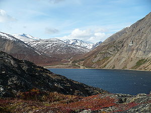
The Torngat Mountains have a substantial geographical extent. About 56% of the range is located in Quebec, 44% is in Labrador, and the remainder, less than 1%, is located on Killiniq Island in Nunavut. At least 2% of the mountain chain is under water, and poorly surveyed. The Torngat Mountains cover 30,067 square kilometres (11,609 sq mi), including lowland areas and extend over 300 km (186 mi) from Cape Chidley in the north to Hebron Fjord in the south. The Torngat Mountains have the highest peaks of eastern continental Canada.

The highest point is Mount Caubvick (also known as Mont D'Iberville) at 1,652 m (5,420 ft). There are no trees in the Torngat Mountains because the mountains lie in an arctic tundra climate and are therefore above the tree line.

Permafrost is continuous on the Quebec side of the border, and it is extensive but discontinuous on the eastern Atlantic side. The terrain is over 300 m (984 ft) above sea level and is predominantly rocky desert.

Highest Peaks of the Torngat Mountains
RankNamemft
1 Mount Caubvick 16525420
2 Torngarsoak Mountain 15955232
3 Cirque Mountain 15685144
4Peak 5100 (24I/16)1554+5100+
5Peak 507415475074
6Mount Erhart15395049
7Jens Haven15315023
8Peak 5000 (24P/01)1524+5000+
9Peak 5000 (24I/16)1524+5000+
10 Innuit Mountain 15094951

Geology

Aerial view of Four Peaks region of Torngat Mountains Labrador-fourpeaks-uwm.png
Aerial view of Four Peaks region of Torngat Mountains

Precambrian gneisses that comprise the Torngat Mountains are among the oldest on Earth and have been dated at roughly 3.6 to 3.9 billion years old. [2] Geologists recognize the gneisses of the Torngats as a part of the Canadian Shield or Laurentian Upland, [3] which, composing the very old North American Craton, split from the continent of Rodinia roughly 750 million years ago to form the geologic core of North America. [4]

However, the mountain-building or orogeny of the Torngats took place much more recently, and is characteristic of the folding and faulting that defines the series of geological events known as Arctic Cordillera. [5] This, according to some, makes the Torngats, as mountains, "distinct compared to the surrounding Precambrian Canadian Shield," [6] though they are ultimately composed of shield rock. Evidence of this dramatic cordilleran folding and faulting characterizing the Torngat Mountains can be seen distinctly in rocks where the North American Craton long ago collided with the Nain Craton, later exposed in cross-section by glacial scouring, especially at Saglek Fjord. [7]

Glaciation

The ranges of the Torngat Mountains are separated by deep fjords and finger lakes surrounded by sheer rock walls. The fjords were produced by glaciation. The Laurentide Ice Sheet covered most of the mountains at least once, however during the last ice age the coverage was more limited.

Currently, there are over 100 active small mountain glaciers in the Torngat Mountains with a total of about 195 ice masses in the region. [8] [9]

Ecology

Torngat Mountain tundra
Nachvak Fjord Labrador 2008.JPG
Torngat Mountains and Nachvak Fjord
Torngat Mountain tundra map.svg
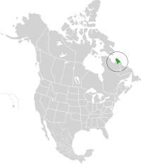
Location of the Torngat Mountain tundra ecoregion in North America
Ecology
Realm Nearctic
Biome Tundra
Borders
Geography
Area32,375 km2 (12,500 sq mi)
Country Canada
Provinces
Climate type Polar
Conservation
Conservation status Relatively Stable/Intact [10]

Flora

The Torngat Mountain tundra is characterized by sparse cover of arctic sedges, grass, lichen, and moss. Patches of mixed arctic evergreen and deciduous shrubs can be found on sheltered south-facing slopes, increasing in prevalence as one moves south. [10]

Fauna

The tundra provides seasonal habitat for caribou, polar bears, and the only tundra-dwelling black bears in the world. In addition, the coastal area of this ecoregion lies along the Atlantic migratory flyway. [10]

Conservation

The Torngat Mountains National Park Reserve was announced on 1 December 2005. It aims to protect wildlife (caribou, polar bears, peregrine falcon and golden eagle among others), while offering wilderness-oriented recreational activities. [11]

In the CBC Series Geologic Journey the Torngat mountains are featured. Notably, a billion-year-old coal seam (based on algae, not peat swamps) was discovered in the Torngat mountains on the Newfoundland Coast as part of the filming of the series.

Backcountry Magazine ran a feature story written by Drew Pogge in 2009 on steep skiing in the Torngat Mountains, notably first descents in Nachvak and Saglek fjords, as well as on the Caubvick massif.

See also

Related Research Articles

<span class="mw-page-title-main">Canadian Shield</span> Geographic and geologic area of North America

The Canadian Shield, also called the Laurentian Plateau, is a geologic shield, a large area of exposed Precambrian igneous and high-grade metamorphic rocks. It forms the North American Craton, the ancient geologic core of the North American continent. Glaciation has left the area with only a thin layer of soil, through which exposures of igneous bedrock resulting from its long volcanic history are frequently visible. As a deep, common, joined bedrock region in eastern and central Canada, the shield stretches north from the Great Lakes to the Arctic Ocean, covering over half of Canada and most of Greenland; it also extends south into the northern reaches of the United States.

<span class="mw-page-title-main">Gros Morne National Park</span> National Park on the west coast of Newfoundland

Gros Morne National Park is a Canadian national park and World Heritage Site located on the west coast of Newfoundland. At 1,805 km2 (697 sq mi), it is the second largest national park in Atlantic Canada after Torngat Mountains National Park, which has an area of 9,700 km2 (3,700 sq mi).

<span class="mw-page-title-main">Thousand Islands – Frontenac Arch</span> Geologic region in North America

The Thousand Islands – Frontenac Arch region or the Frontenac Axis is an exposed strip of Precambrian rock in Canada and the United States that links the Canadian Shield from Algonquin Park with the Adirondack Mountain region in New York, an extension of the Laurentian mountains of Québec. The Algonquin to Adirondacks region, which includes the Frontenac Axis or Arch, is a critical linkage for biodiversity and resilience, and one with important conservation potential. The axis separates the St. Lawrence Lowlands and the Great Lakes Lowlands. It has many distinctive plant and animal species. It is one of four ecoregions of the Mixedwood Plains.

<span class="mw-page-title-main">Geography of Yukon</span>

Yukon is in the northwestern corner of Canada and is bordered by Alaska and the Northwest Territories. The sparsely populated territory abounds with natural scenery, snowmelt lakes and perennial white-capped mountains, including many of Canada's highest mountains. The territory's climate is Arctic in territory north of Old Crow, subarctic in the region, between Whitehorse and Old Crow, and humid continental climate south of Whitehorse and in areas close to the British Columbia border. Most of the territory is boreal forest with tundra being the main vegetation zone only in the extreme north and at high elevations.

<span class="mw-page-title-main">Nachvak Fiord</span>

Nachvak Fjord is a deep fiord in northern Labrador nearly 2 km (1.2 mi) wide and 20 km (12 mi) long. The fjord is divided in two arms on the western end called Tallek and Tasiuyak. The Torngat Mountains that surround Nachvak Fjord are the highest in Labrador, where both Mount Razorback to the north and Mount Caubvick to the south are located.

<span class="mw-page-title-main">Torngat Mountains National Park</span> National park in Newfoundland and Labrador, Canada

Torngat Mountains National Park is a Canadian national park located on the Labrador Peninsula in the province of Newfoundland and Labrador. The park encompasses 9,700 km2 of mountainous terrain between Northern Quebec and the Labrador Sea. It is the largest national park in Atlantic Canada and the southernmost national park in the Arctic Cordillera. It partially contains the Torngat Mountains, the highest mountains in mainland Canada east of the Rocky Mountains.

<span class="mw-page-title-main">Killiniq Island</span> Remote island in northeastern Canada

Killiniq Island is a remote island in southeastern Nunavut and northern Newfoundland and Labrador, Canada. Located at the extreme northern tip of Labrador between Ungava Bay and the Labrador Sea, it is notable in that it contains the only land border between Nunavut and Newfoundland and Labrador. Most other islands off the northern coast of Quebec and Labrador belong exclusively to Nunavut. Some cartographic sources do not correctly show the island's geopolitical boundaries; for instance, the Commission de toponymie du Québec seems to show it as belonging to Quebec.

<span class="mw-page-title-main">Geography of Newfoundland and Labrador</span>

Newfoundland and Labrador is the easternmost province in Canada. The Strait of Belle Isle separates the province into two geographical regions, Labrador and the island of Newfoundland. The province also includes over seven thousand small islands.

<span class="mw-page-title-main">Arctic Cordillera</span> Terrestrial ecozone in northern Canada

The Arctic Cordillera is a terrestrial ecozone in northern Canada characterized by a vast, deeply dissected chain of mountain ranges extending along the northeastern flank of the Canadian Arctic Archipelago from Ellesmere Island to the northeasternmost part of the Labrador Peninsula in northern Labrador and northern Quebec, Canada. It spans most of the eastern coast of Nunavut with high glaciated peaks rising through ice fields and some of Canada's largest ice caps, including the Penny Ice Cap on Baffin Island. It is bounded to the east by Baffin Bay, Davis Strait and the Labrador Sea while its northern portion is bounded by the Arctic Ocean.

The Great Lakes-St. Lawrence Lowlands, or simply St. Lawrence Lowlands, is a physiographic region of Eastern Canada that comprises a section of southern Ontario bounded on the north by the Canadian Shield and by three of the Great Lakes — Lake Huron, Lake Erie and Lake Ontario — and extends along the St. Lawrence River to the Strait of Belle Isle and the Atlantic Ocean. The lowlands comprise three sub-regions that were created by intrusions from adjacent physiographic regions — the West Lowland, Central Lowland and East Lowland. The West Lowland includes the Niagara Escarpment, extending from the Niagara River to the Bruce Peninsula and Manitoulin Island. The Central Lowland stretches between the Ottawa River and the St. Lawrence River. The East Lowland includes Anticosti Island, Îles de Mingan, and extends to the Strait of Belle Isle.

<span class="mw-page-title-main">Eastern Canadian Shield taiga</span> Taiga ecoregion of Labrador and Quebec, Canada

The Eastern Canadian Shield taiga is an ecoregion of Canada as defined by the World Wildlife Fund (WWF) categorization system.

<span class="mw-page-title-main">Baffin coastal tundra</span> Tundra ecoregion of Nunavut, Canada

The Baffin coastal tundra is a small ecoregion of the far north of North America, on the central north coast of Baffin Island in the Canadian territory of Nunavut. This is permafrost tundra with an average annual temperature below freezing.

Kuururjuaq National Park is a 4,460 km2 (1,720 sq mi) national park, created in May 2009 and managed by the Kativik Regional Government, in northeast Quebec, Canada. It stretches all the way from Ungava Bay to Mount D'Iberville, which is on the Newfoundland and Labrador and Quebec border. Mount D'Iberville, at an altitude of 1,646 m (5,400 ft), is the highest mountain in eastern continental Canada, dominating over the entire Torngat Mountain range. The 166 km (103 mi) Koroc River runs through the national park to Ungava Bay. Kuururjuaq National Park contains a variety of different ecosystems and comprises three natural regions: the Torngat Mountain Foothills, the George River Plateau and the Ungava Coast. Like other Nunavik parks, Kuururjuaq National Park is developed and managed by the Inuit.

<span class="mw-page-title-main">Canadian Arctic tundra</span>

The Canadian Arctic tundra is a biogeographic designation for Northern Canada's terrain generally lying north of the tree line or boreal forest, that corresponds with the Scandinavian Alpine tundra to the east and the Siberian Arctic tundra to the west inside the circumpolar tundra belt of the Northern Hemisphere.

The geology of Prince Edward Island formed as a result of strike-slip extension in the mountains formed by the Taconic orogeny, Salinic orogeny and Acadian orogeny, which created an area of subsidence in the Gulf of St. Lawrence. The Maritime Rift resulted in the Magdalen Basin, which is actually a series of small basins surrounded the Gulf. In the Permian coal swamps formed in these basins, resulting in Atlantic Canada's extensive coal deposits, while in some cases the swamps evaporated being replaced by gypsum evaporite. Up to 12 kilometers of late Paleozoic sediments filled the Maritime Rift as rivers transported sediments in from more distant highlands. The rock visible at the surface on Prince Edward Island is principally red sandstone and siltstone deposited during this period.

Caribou herds in Canada are discrete populations of seven subspecies that are represented in Canada. Caribou can be found from the High Arctic region south to the boreal forest and Rocky Mountains and from the east to the west coasts.

<span class="mw-page-title-main">Davis Highlands tundra</span> Tundra ecoregion of Nunavut, Canada

The Davis Highlands tundra ecoregion covers the Baffin Mountains on the northeast coast of Baffin Island and Bylot Island, facing Baffin Bay in Nunavut, northern Canada. The terrain is extremely rugged, heavily glaciated, with many deep fjords, and very cold. About half of the territory is moss and lichen tundra, the other half bare rock and ice. The region is wetter than the much drier regions to the southwest of the Baffin Islands.

<span class="mw-page-title-main">Torngat Mountain tundra</span>

The Torngat Mountain tundra ecoregion covers the Torngat Mountains on the northeastern tip of the Labrador Peninsula where the provinces of Quebec and Newfoundland and Labrador meet. The mountains feature glacially carved U-shaped valleys and deep fjords. The vegetation over most of the territory is that of arctic tundra, herbaceous cover, or bare rock. The region supports seasonal polar bears, black bears, and caribou. The Atlantic coast is on the Atlantic Flyway for migratory birds.

References

  1. Park Wardens - Arctic Cordillera Archived 2008-02-17 at the Wayback Machine
  2. 1 2 "Torngat Mountains National Park Reserve". Parks Canada. Archived from the original on 2007-10-22. Retrieved 2009-01-10.
  3. "Archived copy" (PDF). Archived from the original (PDF) on 2008-02-16. Retrieved 2007-12-27.{{cite web}}: CS1 maint: archived copy as title (link)
  4. Nick Eyles and Andrew Miall, Canada Rocks: The Geologic Journey (Markham, Ont., Fitzhenry & Whiteside: 2007) pp. 66–67.
  5. Nick Eyles and Andrew Miall, Canada Rocks: The Geologic Journey (Markham, Ont., Fitzhenry & Whiteside: 2007)
  6. Exhumation of the Torngat Mountains, Northern Labrador, Canada Archived 2008-08-28 at the Wayback Machine , J. P. Centeno, D. F. Stockli, J. Gosse.
  7. Nick Eyles and Andrew Miall, Canada Rocks: The Geologic Journey (Markham, Ont., Fitzhenry & Whiteside: 2007) p. 100.
  8. R.Way (2013). The Glaciers of the Torngat Mountains of northern Labrador. Memorial University of Newfoundland. MSc Thesis, St. John's, Newfoundland and Labrador.
  9. "An inventory and topographic analysis of glaciers in the Torngat Mountains, northern Labrador, Canada". Journal of Glaciology. Retrieved 2014-10-31.
  10. 1 2 3 "Torngat Mountain tundra | Ecoregions | WWF". World Wildlife Fund. Archived from the original on 2020-08-11. Retrieved 2020-11-13.
  11. "Torngat Mountains National Park Reserve". Parks Canada. Archived from the original on 2007-10-22. Retrieved 2008-06-17.

Further reading