Related Research Articles

The Arctic Archipelago, also known as the Canadian Arctic Archipelago, groups together all islands lying to the north of the Canadian continental mainland excluding Greenland.

Axel Heiberg Island is an island in the Qikiqtaaluk Region, Nunavut, Canada. Located in the Arctic Ocean, it is the 32nd largest island in the world and Canada's seventh largest island. According to Statistics Canada, it has an area of 43,178 km2 (16,671 sq mi). It is named after Axel Heiberg.
Turnabout Glacier is located on Ellesmere Island, Nunavut, Canada. It is drained by the Turnabout River.
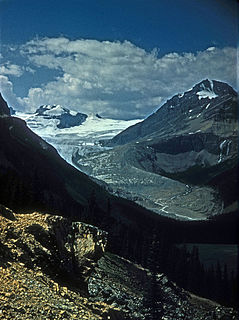
The Peyto Glacier is situated in the Canadian Rockies in Banff National Park, Alberta, Canada, approximately 90 km (56 mi) northwest of the town of Banff, and can be accessed from the Icefields Parkway. Peyto Glacier is an outflow glacier from the Wapta Icefield, which rests along the Continental divide. The glacier snout is subject to high melt rates from season to season and there is marked surface lowering on several parts of the glacier. Glacial silt, which is carried from the glacier by streams, ensures a turquoise appearance to Peyto Lake, a popular touring destination. As is true for the vast majority of glaciers worldwide, Peyto Glacier has been retreating rapidly, especially since the last half of the 20th century, and has reportedly lost 70% of its mass since it was first researched (Demuth and Keller, 2006). Between 1896 and 1966, the total volume loss of the Peyto Glacier was 1088.5 x 106 m3 (Wallace, 1995). In 1987, an automatic weather station was constructed near the glacier that monitors temperature changes, radiation and precipitation.
Benedict Glacier is a glacier on central Ellesmere Island, Nunavut, Canada.
Kaparoqtalik Glacier is a glacier located in the southern coast of the Byam Martin Mountains on Bylot Island, Nunavut, Canada. It lies in Sirmilik National Park.

Gull Glacier is a glacier in the Osborn Range of north-central Ellesmere Island, Nunavut, Canada. It lies in the Tanquary Fiord in Quttinirpaaq National Park.
Sven Hedin Glacier is a glacier north of Princess Marie Bay on central Ellesmere Island, Nunavut, Canada. The glacier has the name of Sven Hedin. The Oxford University Ellesmere Land expedition visited the glacier in the year 1935. The Glacier appeared to be advancing in 1935.
Eugenie Glacier is a glacier on central Ellesmere Island, Nunavut, Canada. It rises to approximately 364 m (1,194 ft) above sea level.
Narsarsuk Glacier is a glacier in the southeastern Byam Martin Mountains of Bylot Island, Nunavut, Canada.
CKAY-FM is a Canadian radio station that broadcasts a classic hits format at 91.7 FM, licensed to Gibsons, British Columbia with studios in Sechelt. The station targets Nanaimo and the Sunshine Coast.
Stella is an unincorporated community in Carteret County, North Carolina, United States.

Scotsguard is an unincorporated community within the Rural Municipality of Bone Creek No. 108, Saskatchewan, Canada. The community is located on Highway 13, also known as the historic Red Coat Trail, about 10 km northeast of the town of Shaunavon.

Dumfries is an unincorporated community in York County, New Brunswick, Canada. It is named for Dumfries, Scotland, the original home of Adam Allen, an early settler.
CHOC-FM is a French language community radio station that operates at 104.9 MHz (FM) in Saint-Rémi, Quebec, Canada.
The Glacier Strait is a natural waterway through the Canadian Arctic Archipelago within Qikiqtaaluk Region, Nunavut, Canada. It separates Ellesmere Island from Coburg Island. To the north-east it opens into Baffin Bay, and to the south-west into the Jones Sound.
The Enterprise Hills are a prominent group of largely ice-free hills and peaks in the form of an arc. The feature extends for about 30 nautical miles (60 km) to form the north and northeast boundary of Horseshoe Valley in the Heritage Range of the Ellsworth Mountains. These hills were mapped by the United States Geological Survey from surveys and U.S. Navy air photos, 1961–66; the name was applied by the Advisory Committee on Antarctic Names in association with the name Heritage Range.
Parrish Peak is a very pointed, partly snow-topped peak, 1,775 m, surmounting the ridge next south of Seal Glacier in the Enterprise Hills, Heritage Range. It was mapped by the United States Geological Survey (USGS) from surveys and U.S. Navy air photos from 1961-66. It was named by the Advisory Committee on Antarctic Names (US-ACAN) for Edward N. Parrish, a glaciologist on the United States Antarctic Research Program (USARP) South Pole—Queen Maud Land Traverse I and II, 1964–65 and 1965-66.

Seal Glacier is a small glacier draining east, located just north of Parrish Peak in the Enterprise Hills, Heritage Range. Mapped by United States Geological Survey (USGS) from surveys and U.S. Navy air photos, 1961-66. Named by Advisory Committee on Antarctic Names (US-ACAN) for radioman G.L. Seal, U.S. Navy, who up to Operation Deepfreeze 1966 had contributed to efficient communications during four austral summer seasons.

Buneva Point is the sharp rocky point on the northwest coast of Alexander Island in Antarctica projecting 1 km west-southwestwards into Lazarev Bay just south of the terminus of Lennon Glacier. It is formed by the north extremity of the homonymous rocky coastal ridge extending 3.7 km in southeast direction.
References
- ↑ Parrish Glacier Archived 2012-10-02 at the Wayback Machine at the Atlas of Canada
Coordinates: 79°37′26″N077°09′02″W / 79.62389°N 77.15056°W
| This Qikiqtaaluk Region, Nunavut location article is a stub. You can help Wikipedia by expanding it. |
| This article about a glacier in Canada is a stub. You can help Wikipedia by expanding it. |