Wapiti Pass is a mountain pass in the Northern Rocky Mountains of British Columbia, Canada. It lies immediately east of Wapiti Lake Provincial Park, at the headwaters of the Wapiti River, northeast of Prince George and west of Monkman Provincial Park.

The Dickson Range is a subrange of the Chilcotin Ranges subset of the Pacific Ranges of the Coast Mountains in southwest-central British Columbia. It is located just west of the town of Gold Bridge between the valley of Slim Creek to the north and Downton Lake Reservoir to the south. At its eastern foot is Gun Lake; its western limit is at a pass between Slim Creek and Nichols Creek near the pass which separates the Bridge River basin from that of the Lord River, which feeds the Taseko Lakes.

South Stann Creek is a watercourse in southeastern Belize. The administrative division, Stann Creek District, is named after the river. South Stann Creek rises in the foothills of the eastern slopes of the Maya Mountains within the Cockscomb Basin Wildlife Sanctuary. It drains the Cockscomb West Basin.

Elbow Pass is the mountain pass between the Highwood and Elbow areas in Kananaskis Country, Alberta, Canada. It contains Elbow Lake which is the headwaters of the Elbow River.
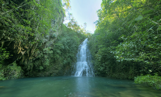
The Cockscomb Basin Wildlife Sanctuary is a nature reserve in the Stann Creek District of south-central Belize. It was established to protect the forests, fauna and watersheds of an approximately 400 square kilometres (150 sq mi) area of the eastern slopes of the Maya Mountains.
Victoria Peak within the Maya Mountains is the second highest mountain in Belize, at a height of 1,120 metres (3,675 ft). The highest peak in the country, Doyle's Delight, at a height of 1,124 metres (3,688 ft), is located 57 kilometres (35 mi) southwest of Victoria Peak. Victoria Peak is situated in the Stann Creek District of Belize, in the Cockscomb Basin Wildlife Sanctuary, and is home to many flora and fauna common to Belize. It was pronounced a natural monument in 1998, comprising about 4,847 acres bordered by the Sittee River Wildlife Reserve, Cockscomb Basin Wildlife Sanctuary, and Chiquibul National Park.
Bush Pass is a mountain pass in the Canadian Rockies, on the border between the Canadian provinces of Alberta and British Columbia. It is located at the headwaters of the Valenciennes River, formerly known as the South Fork Bush River; the North Fork Bush River is now known as the Bush River.
Simpson Pass, el. 2,107 m (6,913 ft), is a mountain pass on the border between the Canadian provinces of Alberta and British Columbia, in the area of the Ball Range. It is the prominence col for Mount Ball on the Continental Divide in the vicinity of Sunshine Village ski resort. Simpson River and Simpson Pass are named after Sir George Simpson who first explored the area in 1841.

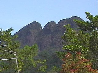
Cockscomb Mountain was named in 1921 because the outline of the summit was said to resemble a roosters comb. It is located in the Sawback Range in Alberta. The mountain is composed of sedimentary rock laid down during the Precambrian to Jurassic periods. Formed in shallow seas, this sedimentary rock was pushed east and over the top of younger rock during the Laramide orogeny.

Vermilion Pass, elevation 1,680 m or 5,510 ft, is a high mountain pass in the Canadian Rockies, traversing the continental divide. It connects Kootenay National Park in the province of British Columbia with Banff National Park in Alberta.
Wedge Pass, also known as Billygoat Pass, 1,430 m (4,690 ft), is a mountain pass in the northern Garibaldi Ranges, the southwesternmost subdivisions of the Pacific Ranges of the Coast Mountains in British Columbia, Canada. Located immediately on the southern flank of Wedge Mountain and to the immediate north of the Spearhead Range, site of the Blackcomb half of the Whistler Blackcomb Ski Area, it connects the head of Wedge Creek (W), a tributary of the Green River with those of Billgoat Creek (E), a tributary of the Lillooet River. The pass is within Garibaldi Provincial Park and has no road access.
Carcajou Pass is a mountain pass on the Continental Divide and British Columbia–Alberta boundary at the north end of Mount Robson Provincial Park. On the Alberta side lies the northwestern part of Jasper National Park. Carcajou is the French word for "wolverine".
Summit Pass is a high mountain pass in the Northern Canadian Rockies in the province of British Columbia. It is one of two passes the Alaska Highway utilizes to cut westwards across ranges of the Rocky Mountain System; further north is the lower Muncho Pass.
Muncho Pass, also known as Muncho Lake Pass, Drogheda Lake Pass, or Muncho-Toad Pass, is the northernmost mountain pass in the Rocky Mountains to be traversed by a public highway. Located in Muncho Lake Provincial Park, British Columbia, Canada, the pass links the Toad River and Trout River drainages. The Alaska Highway travels across the pass.
Fortress Pass is a mountain pass that crosses the continental divide in the Canadian Rockies, south of Jasper, Alberta. At 1,335 metres (4,380 ft), Fortress Pass is one of the lowest passes to cross the Canadian Rockies that is not traversed by a road. In addition to being at a low elevation, Fortress Pass is also relatively gentle, with almost no elevation difference between water bodies on either side.
Tonquin Pass, 1948 m (6393 ft), is a mountain pass in the Canadian Rockies, linking Tonquin Valley in Jasper National Park, Alberta, to Mount Robson Provincial Park and adjoining areas of British Columbia. It is at the headwaters of Tonquin Creek, which flows into British Columbia. Located on the interprovincial boundary, it is on the Continental Divide.
Cockscomb Buttress is a prominent, isolated rock buttress rising to 465 metres (1,530 ft), standing 1 nautical mile (2 km) northwest of Echo Mountain and overlooking the east side of Norway Bight on the south coast of Coronation Island, in the South Orkney Islands. The name, which is descriptive, was given by the Falkland Islands Dependencies Survey following their survey of 1950.
The Cockscomb is a high mountain in the Eastern Cape, in South Africa. It gets its name from its resemblance to a fowl's comb. It is situated in the Baviaanskloof region and the nearest town is Patensie. The Cockscomb is part of the Groot Winterhoek range. Its peak is 1,768 m (5,801 ft) or 1,752 m (5,748 ft) above sea level, depending on the source.

Budd Lake is a lake in the Tuolumne Meadows region of Yosemite National Park, United States. Budd Lake is the source of Budd Creek.
Arviqtujuq Kangiqtua formerly Eglinton Fiord is a fjord on Baffin Island's northeastern coast in the Qikiqtaaluk Region of Nunavut, Canada. The Inuit settlement of Pond Inlet is 355 km (221 mi) to the northwest and Clyde River is 55 km (34 mi) to the east.
