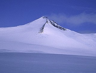
Barbeau Peak is a mountain in Qikiqtaaluk, Nunavut, Canada. Located on Ellesmere Island within Quttinirpaaq National Park, it is the highest mountain in Nunavut and the Canadian Arctic. The mountain was named in 1969 after Marius Barbeau, a Canadian anthropologist whose research into First Nations and Inuit cultures gained him international acclaim.

Mount Humphreys is a mountain peak in the Sierra Nevada on the Fresno-Inyo county line in the U.S. state of California. It is the 13th highest peak in California, and the highest peak in the Bishop area. The mountain was named by the California Geological Survey of 1873 for Andrew A. Humphreys, the chief engineer of the United States Army at the time.

The Kaumajet Mountains are a dramatic compact mountain range rising directly out of the sea on the northern Labrador coast. The mountain range has one 4,000-foot (1,200 m) peak, the highest island peak on the east coast of North America between the Caribbean and Hudson Strait, and several peaks with very high prominence. The highest mountain in the Kaumajet Mountains is Brave Mountain at 1,300 m (4,265 ft).
Mount Queen Bess is one of the principal summits of the Pacific Ranges of the Coast Mountains of southern British Columbia. It stands west of Chilko Lake and to the south of Tatlayoko Lake, and crowns a peak-studded ridge to the north of the Homathko Icefield.

Gray Peak is a mountain located in the town of Keene in Essex County, New York. It is the seventh-highest of the Adirondack High Peaks, with an elevation of 4,840 feet (1,480 m), and is located in close proximity to Mount Marcy, the highest peak in New York. Gray Peak is southwest of Mount Marcy and southeast of Mount Colden. The first recorded ascent of the peak was made on September 16, 1872, by surveyor Verplanck Colvin and guide Bill Nye. It was named for Asa Gray by Colvin. Although the mountain is only 0.6 miles (0.97 km) from the summit of Marcy and lacked prominence desired by the Marshall brothers for inclusion in the High Peaks, it was added to the list to preserve the name.

Plinth Peak, sometimes called Plinth Mountain, is the highest satellite cone of the Mount Meager massif, and one of four overlapping volcanic cones which together form a large volcanic complex in the Garibaldi Volcanic Belt of the Canadian Cascade Arc. It is one of the most recently formed volcanic formations of the Mount Meager massif.

The La Plata Mountains are a small subrange of the San Juan Mountains in the southwestern part of Colorado, United States. They are located on the border between Montezuma and La Plata counties, about 12 miles (19 km) northwest of Durango. Their name is Spanish for silver.

Mount Odin is a mountain in Qikiqtaaluk, Nunavut, Canada. It is located in Auyuittuq National Park along the Akshayuk Pass, 46 km (29 mi) north of Pangnirtung and south of Mount Asgard. Mount Odin is the highest mountain on Baffin Island.
Mount Redfield is a mountain in the Adirondacks in the U.S. state of New York. It is the 15th-highest peak in New York, with an elevation of 4,606 feet (1,404 m), and one of the 46 High Peaks in Adirondack Park. It is located in the town of Keene in Essex County, near Cliff Mountain and Mount Skylight. Surveyor Verplanck Colvin named the mountain after William C. Redfield, organizer and member of an expedition to Mount Marcy in 1837, and the first to guess that Marcy was the highest peak in the Adirondacks, and therefore in New York. The earliest recorded ascent was made in 1894 by mountain guide Ed Phelps and a guest whose name has not been recorded.
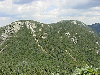
Saddleback Mountain is a mountain in the Great Range of the Adirondacks in the U. S. state of New York. It is the 17th-highest of the Adirondack High Peaks, with an elevation of 4,515 feet (1,376 m). It is located in Adirondack Park in the town of Keene in Essex County. The mountain was named for the outline of its ridge, which resembles a saddle, by Orson Schofield Phelps and Frederick Perkins. It is flanked by Basin Mountain, the ninth highest of the High Peaks, and Gothics, the tenth highest. Good views of the two higher mountains are offered from the summit of Saddleback. The mountain straddles the watersheds of Johns Brook and the Ausable River. The earliest recorded ascent was made by amateur climber Newell Martin on August 5, 1894. It was claimed that an earlier ascent was made by patent lawyer James J. Storrow and mountain guide Orlando Beede, but the date of this climb is unknown.
Outlook Peak is a mountain in Qikiqtaaluk, Nunavut, Canada, located on the southwestern edge of the Muller Icecap. It is the highest mountain of the Princess Margaret Range at 2,210 m (7,251 ft), the highest on Axel Heiberg Island, and the fourth highest in Nunavut.
Kisimngiuqtuq Peak is a mountain in Qikiqtaaluk, Nunavut, Canada. It is associated with the Baffin Mountains on Baffin Island. It is the tenth highest peak in Nunavut and the eleventh highest peak in Nunavut by topographic prominence.
Ukpik Peak is a mountain associated with the Baffin Mountains on Baffin Island, Nunavut, Canada.

Goat Mountain, at 11,913 feet (3,631 m) above sea level is the second highest peak in the Pioneer Mountains of Idaho. The peak is located on the border of Sawtooth and Salmon-Challis National Forests as well as Blaine and Custer counties. It is the 16th highest peak in Idaho and less than 2 mi (3.2 km) north-northwest of Hyndman Peak.
Bell Mountain, at 11,612 feet (3,539 m) above sea level, is the second highest peak in the Lemhi Range of Idaho. The peak is the highest point in Lemhi County and located 0.2 mi (0.32 km) north of the border with Butte County. The peak is located on the border of Caribou-Targhee National Forest and Salmon-Challis National Forest. It is about 9.5 mi (15.3 km) northwest of Diamond Peak. It is the 37th highest peak in Idaho.

Snowyside Peak, at 10,651 feet (3,246 m) above sea level, is the fifth-highest peak in the Sawtooth Range of the U.S. state of Idaho. The peak is located in the Sawtooth Wilderness of Sawtooth National Recreation Area at the intersection of Blaine, Custer County, and Elmore counties. It is the highest point in Elmore County. The peak is located 5.1 miles (8.2 km) south of Mount Cramer, its line parent. It is the 217th-highest peak in Idaho.

San Miguel Mountain is a mountain in Chula Vista, California. It is 2,567' high, and is the 84th highest peak in San Diego County.

Reo Purgyil, sometimes known as Leo Pargial and Leo Pargil, is a mountain peak at the southern end of the Zanskar Range in the Western Himalaya. It is located on the border between Himachal Pradesh, India and Tibet, China.
