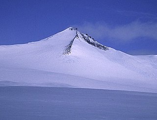
Barbeau Peak is a mountain in Qikiqtaaluk, Nunavut, Canada. Located on Ellesmere Island within Quttinirpaaq National Park, it is the highest mountain in Nunavut and the Canadian Arctic. The mountain was named in 1969 after Marius Barbeau, a Canadian anthropologist whose research into First Nations and Inuit cultures gained him international acclaim.

Mount Nirvana, at 2,773 m (9,098 ft) is the unofficial name of the highest mountain in the Northwest Territories, Canada. The mountain is a part of Nahanni National Park Reserve, the largest national park in the Northwest Territories.

Keele Peak, in Yukon, Canada is the highest peak in the Mackenzie Mountains at 2,952 metres (9,685 ft). With a prominence measure of 2,157 m (7,077 ft) it is one of Canada's most prominent peaks. It is located about 25 km from the Canol Road not far from the Northwest Territories border.

Qikiqtaaluk (ᕿᑭᖅᑖᓗᒃ) formerly Sillem Island is an uninhabited island in the Qikiqtaaluk Region of Nunavut, Canada. It is the second largest of the several hundred islands and islets that are located in Baffin Bay, immediately off the northern coast of Baffin Island. It is defined by Clark and Gibbs Fiords, which join at its northern end to form Scott Inlet. Further north lies Pilattuaq.

This article comprises three sortable tables of major mountain peaks of Canada.

Qiajivik Mountain is a mountain in Qikiqtaaluk, Nunavut, Canada. Located in northeastern Baffin Island, it is part of the Baffin Mountains. At 1,965 m (6,447 ft) Qiajivik is the highest mountain in northern Baffin Island and with a topographic prominence of 1,787 m (5,863 ft) it is one of Canada's 142 ultra-prominent peaks.

The Baffin Mountains are a mountain range running along the northeastern coast of Baffin Island and Bylot Island, Nunavut, Canada. The ice-capped mountains are part of the Arctic Cordillera and have some of the highest peaks of eastern North America, reaching a height of 1,525–2,146 metres (5,003–7,041 ft) above sea level. While they are separated by bodies of water to make Baffin Island, they are closely related to the other mountain ranges that make the much larger Arctic Cordillera mountain range.

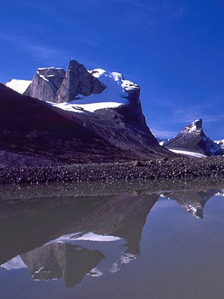
Mount Odin is a mountain in Qikiqtaaluk, Nunavut, Canada. It is located in Auyuittuq National Park along the Akshayuk Pass, 46 km (29 mi) north of Pangnirtung and south of Mount Asgard. Mount Odin is the highest mountain on Baffin Island.
Angilaaq Mountain is a mountain in Qikiqtaaluk Region, Nunavut, Canada. It is located 62 km (39 mi) north of Pond Inlet. It is the highest mountain on Bylot Island and lies in the Byam Martin Mountains, which is a northern extension of the Baffin Mountains.
Breidablik Peak is a mountain on Baffin Island, located 51 km (32 mi) northeast of Pangnirtung, Nunavut, Canada. It lies in the southern Baffin Mountains which in turn form part of the Arctic Cordillera mountain system. Like Mounts Odin and Asgard and other peaks in the Arctic Cordillera, its name comes from Norse mythology. It is named after Breidablik, the home of Baldr.
Mount Baldr is a mountain on Baffin Island, located 49 km (30 mi) northeast of Pangnirtung, Nunavut, Canada. It lies in the southern Baffin Mountains, which in turn form part of the Arctic Cordillera mountain system. Like nearby Breidablik Peak and Mount Odin and other peaks in the Arctic Cordillera, its name comes from Norse mythology. It is named after Baldr, a god in Germanic paganism and is Odin's second son.
Akshayuk Pass formerly Pangnirtung Pass is a mountain pass in the Baffin Mountains of Nunavut, Canada. It is found within Auyuittuq National Park. To the southwest is Mount Thor, about 17 km (11 mi), and Pangnirtung, about 64 km (40 mi) and to the northeast is Qikiqtarjuaq, about 109 km (68 mi).

Midnight Sun Peak is a mountain in the Baffin Mountains, Baffin Island, Nunavut, Canada. It is part of the Auyuittuq National Park area with an elevation of 1,967 m (6,453 ft).
Ukpik Peak is a mountain associated with the Baffin Mountains on Baffin Island, Nunavut, Canada.
Bastille Peak is a mountain located 74 km (46 mi) north of Pangnirtung, Baffin Island, Nunavut, Canada. It is associated with the Baffin Mountains which in turn form part of the Arctic Cordillera mountain system.
Angna Mountain is a mountain located on Baffin Island, Nunavut, Canada. It is associated with the Baffin Mountains which in turn form part of the Arctic Cordillera mountain system.

The Remote Peninsula is a peninsula located on the eastern coast of Baffin Island. It is part of the Qikiqtaaluk Region of the Canadian territory of Nunavut. The Inuit settlement of Pond Inlet is 295 km (183 mi) to the northwest and Clyde River is 90 km (56 mi) to the southeast.
