Related Research Articles
Gill is a rural unincorporated community in south central Harrison County, Texas, United States. It is six miles south of the county seat, Marshall, on U.S. Route 59.
Lazbuddie is an unincorporated community in Parmer County, Texas, United States. Named for local business owner, Luther "Laz" Green, and his partner, Andrew "Buddie" Sherley, the community grew up around the store they opened in 1924. Later a post office and school were established. The town has two cotton gins, a grain elevator, a hardware store, and several churches. The community's focal point is the Lazbuddie Independent School District which educates children from the surrounding rural area. Six-man football is played at Lazbuddie High School. On May 10, 1991, 3 tornadoes hit the ground in Lazbuddie and the event was caught on camera by farmers.
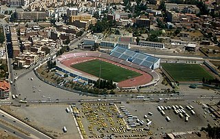
8 May 1945 Stadium is a multi-use stadium in Sétif, Algeria. It is currently used mostly for football matches and is the home ground of ES Sétif. The stadium holds 25,000 people.

Jackson Township is in Will County, Illinois. As of the 2010 census, its population was 4,100 and it contained 1,610 housing units.

Sheldon Glacier is a glacier flowing southeast from Mount Mangin into Ryder Bay, Adelaide Island, Antarctica. Named by the United Kingdom Antarctic Place-Names Committee (UK-APC) in 1977 for Ernest B. Sheldon, British Antarctic Survey (BAS) meteorological observer, Adelaide Station, 1968–69, and Stonington Island, 1969–70; Base Commander, Adelaide Station, 1975–76, and Rothera Station, 1976–77.
Keyhole Glacier is a glacier located in the central Baffin Mountains of northeastern Baffin Island, Nunavut, Canada.
Kiitarayuk Glacier is a glacier located on the central coast of the Baffin Mountains on northeastern Baffin Island, Nunavut, Canada.
Zephyr Glacier 1 is a glacier, about 8 miles (13 km) long, flowing westward from the southwest side of Mount Edgell into George VI Sound to the south of Cape Jeremy. The feature was surveyed by Falkland Islands Dependencies Survey (FIDS), 1948, and British Antarctic Survey (BAS), 1971–72; photographed from the air by U.S. Navy, 1966. Named by United Kingdom Antarctic Place-Names Committee (UK-APC) in 1977 after Zephyrus, the west wind. One of several features in this area named after winds.
Zonda Glacier is a glacier about 8 miles (13 km) long, flowing west-southwest between Fohn Bastion and Zonda Towers into George VI Sound. The glacier was included in surveys by Falkland Islands Dependencies Survey (FIDS), 1948, and British Antarctic Survey (BAS), 1971–72, and was photographed from the air by the U.S. Navy, 1966. The name applied by United Kingdom Antarctic Place-Names Committee (UK-APC) in 1977 continues the theme of wind names in the area, as "zonda wind" is the Argentine name for the warm dry wind descending the east slopes of the Andes.
Isle of Wight Wildlife Management Area is a state wildlife management area (WMA) of Maryland located on the Isle of Wight, a small peninsula between the St. Martin's River and Isle of Wight Bay in Worcester County. Although called Isle of Wight, a small strip of marsh and road connects it with the mainland.
Kinderhook is an unincorporated community located in Madison and Greene counties, Virginia, United States.
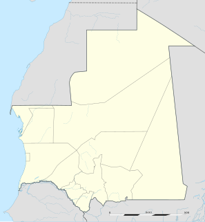
Fassala , Fassale, Fessale, or Vassale is a town and commune in the Hodh Ech Chargui Region of south-eastern Mauritania, on the Malian border.

An Thạnh Trung is a rural commune (xã) and village of the Chợ Mới District of An Giang Province, Vietnam.
Carlson Glacier is a glacier, 9 nautical miles (17 km) long, flowing northward from between Mount Edgell and the Relay Hills into Wordie Ice Shelf, Fallières Coast. It was photographed from the air by the U.S. Navy in 1966, and surveyed by the British Antarctic Survey between 1970 and 1973. It was named by the Advisory Committee on Antarctic Names after Captain Burford A. Carlson, U.S. Navy, Staff Meteorologist, Naval Support Force, Antarctica, Operation Deep Freeze, 1970 and 1971.
Eureka Glacier is a broad, gently sloping glacier, 18 nautical miles (33 km) long and 17 nautical miles (31 km) wide at its mouth, which flows westward from the west side of Palmer Land into George VI Sound. It is bounded on its north side by the nunataks south of Mount Edgell, on its south side by the Traverse Mountains and Terminus Nunatak, and at its head Prospect Glacier provides a route to the Wordie Ice Shelf. It was first surveyed in 1936 by the British Graham Land Expedition (BGLE) under John Rymill and resurveyed in 1948 by the Falkland Islands Dependencies Survey. The name, from the ancient Greek word eureka, expresses the triumph of discovery and arose because the BGLE sledge party found their way to George VI Sound via this glacier in 1936.
Sirocco Glacier is a glacier about 3 nautical miles (6 km) long flowing north-northeast into West Bay, Fallières Coast, between Brindle Cliffs and Mount Edgell. Named by the United Kingdom Antarctic Place-Names Committee (UK-APC) in 1977 after the sirocco, the Italian name for the wind that blows from the Sahara. One of several features in the area named after winds.

Farad is a former settlement in Nevada County, California. Farad is located on the Southern Pacific Railroad, 1 mile (1.6 km) south-southwest of Mystic. The Truckee River crosses Farad halfway between Truckee, CA and Reno, NV.

Vergilov Ridge is a submarine ridge in South Bay, Livingston Island in the South Shetland Islands, Antarctica. It extends 3.5 km in a southeast-northwest direction between the Vergilov Rocks and the opposite Pimpirev Beach at a depth of over 50 m, with depths exceeding 100 m on both sides of the ridge. It was formed as a frontal moraine of Perunika Glacier between the 13th and 17th centuries.
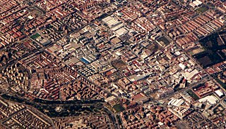
Simancas is an administrative neighborhood (barrio) of Madrid belonging to the district of San Blas-Canillejas. It has an area of 2.278418 km2 (0.879702 sq mi). As of 1 February 2020, it has a population of 28,799.

Alameda de Osuna is a ward (barrio) of Madrid belonging to the district of Barajas.
References
Coordinates: 69°23′35″N068°25′41″W / 69.39306°N 68.42806°W
| | This Qikiqtaaluk Region, Nunavut location article is a stub. You can help Wikipedia by expanding it. |
| | This article about a glacier in Canada is a stub. You can help Wikipedia by expanding it. |