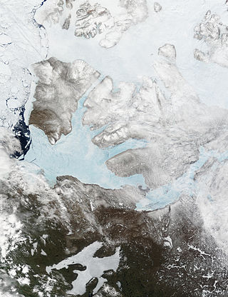
Banks Island is one of the larger members of the Arctic Archipelago. Situated in the Inuvik Region, and part of the Inuvialuit Settlement Region, of the Northwest Territories, it is separated from Victoria Island to its east by the Prince of Wales Strait and from the mainland by Amundsen Gulf to its south. The Beaufort Sea lies to its west, and to its northeast M'Clure Strait separates the island from Prince Patrick Island and Melville Island.
Quttinirpaaq National Park is located on the northeastern corner of Ellesmere Island in the Qikiqtaaluk Region of Nunavut, Canada. It is the second most northerly park on Earth after Northeast Greenland National Park. In Inuktitut, Quttinirpaaq means "top of the world". It was established as Ellesmere Island National Park Reserve in 1988, and the name was changed to Quttinirpaaq in 1999, when Nunavut was created, and became a national park in 2000. The reserve covers 37,775 km2 (14,585 sq mi), making it the second largest park in Canada, after Wood Buffalo National Park.

The Canadian Wildlife Service or CWS, is a Branch of the Department of Environment and Climate Change Canada, a department of the Government of Canada. November 1, 2012 marked the 65th anniversary of the founding of Service.

Wapusk National Park is Canada's 37th national park, established in 1996. The name comes from the Cree word for polar bear (wâpask).

The Peary caribou is a subspecies of caribou found in the High Arctic islands of Nunavut and the Northwest Territories in Canada. They are the smallest of the North American caribou, with the females weighing an average of 60 kg (130 lb) and the males 110 kg (240 lb). In length the females average 1.4 m and the males 1.7 m.

The barren-ground caribou is a subspecies of the reindeer that is found in the Canadian territories of Nunavut and the Northwest Territories, in northern Alaska and in south-western Greenland. It includes the Porcupine caribou of Yukon and Alaska. The barren-ground caribou is a medium-sized caribou, smaller and lighter-colored than the boreal woodland caribou, with the females weighing around 90 kg (200 lb) and the males around 150 kg (330 lb). However, on some of the smaller islands, the average weight may be less. The large migratory herds of barren-ground caribou take their names from the traditional calving grounds, such as the Ahiak herd, the Baffin Island herds, the Bathurst herd, the Beverly herd, the Bluenose East herd, the Bluenose West herd, the Porcupine herd and the Qamanirjuaq herd.
Southern James Bay is a coastal wetland complex in northeastern Ontario, Canada bordering James Bay and Quebec. It was designated as a wetland of international importance via the Ramsar Convention on May 27, 1987. The shallow waters of the James Bay region represent an important late autumn staging area for migratory, Arctic-breeding waterbirds.

Dewey Soper Migratory Bird Sanctuary, or Dewey Soper, is a migratory bird sanctuary in the Qikiqtaaluk Region, Nunavut, Canada. It is located in western Baffin Island, from Bowman Bay to the Koukdjuak River, and is named in honour of zoologist J. Dewey Soper. It is an 8,159 km2 (3,150 sq mi) area that was classified a wetland of international importance via the Ramsar Convention on May 24, 1982. The bird sanctuary supports nearly 30% of the breeding geese in Canada, making it the largest goose colony in the world. Up to two million birds of various species use the area for summer nesting, and it is also "habitat for one of Canada's major barren-ground caribou herds". The sanctuary was established in 1957, and is subject to the Nunavut Land Claims Agreement, which defines and governs ownership, land use and hunting rights in the area.

Polar Bear Pass National Wildlife Area is a National Wildlife Area on Bathurst Island within Qikiqtaaluk, Nunavut, Canada. It is on federal Crown land, and is administered by the Canadian Wildlife Service, a division of Environment Canada, with respect to the Canada Wildlife Act's National Wildlife Area Regulations. Land use is also subject to the Nunavut Land Claims Agreement. To the north and west is Qausuittuq National Park.

The Quill Lakes are a wetland complex in Saskatchewan, Canada that encompasses the endorheic basin of three distinct lake wetlands: Big Quill Lake, Middle Quill Lake, and Little Quill Lake. On May 27, 1987, it was designated a wetland of international importance via the Ramsar Convention. It was the first Canadian site in the North American Waterfowl Management Plan, is a site in the International Biological Programme and Saskatchewan Heritage Marsh Program, and was designated a Western Hemisphere Shorebird Reserve Network site of International significance in May, 1994. The site is an important staging and breeding area for spring and fall migration of shorebirds. The site qualifies as an Important Bird Area (IBA) of Canada for its globally and nationally significant migratory and breeding populations of more than a dozen species of birds. The IBA is designated as Quill Lakes .
The Rasmussen Lowlands is a 3,000 km2 coastal plain complex of wetlands in the Kitikmeot Region, Nunavut, Canada. It was designated a Ramsar wetland of international importance by the Ramsar Convention on May 24, 1982. It is also classified as an Important Bird Area.

The wildlife of Canada or biodiversity of Canada consist of over 80,000 classified species, and an equal number thought yet to be recognized. Known fauna and flora have been identified from five kingdoms: protozoa represent approximately 1% of recorded species; chromist ; fungis ; plants ; and animals. Insects account for nearly 70 percent of documented animal species in Canada. More than 300 species are found exclusively in Canada.
The Queen Maud Gulf Migratory Bird Sanctuary is Canada's largest federally owned protected area, encompassing some 61,765 km2 (23,848 sq mi) of the Arctic Circle coastline. 6,710 km2 (2,590 sq mi) are marine, and 55,055 km2 (21,257 sq mi) are terrestrial.
Seymour Island is an uninhabited island in the Qikiqtaaluk Region of northern Canada's territory of Nunavut. A member of the Berkeley Islands group, it is located approximately 30 mi (48 km) north of northern Bathurst Island. Between Seymour Island and Bathurst Island lies Helena Island. Penny Strait lies about 90 km (56 mi) to the east where open water polynyas occur.

Qausuittuq National Park is a national park located on northwest Bathurst Island in Nunavut. It was established on September 1, 2015, becoming Canada's 45th national park.

Dolphin and Union Caribou, Dolphin and Union caribou herd, Dolphin-Union, locally known as Island Caribou, are a migratory population of barren-ground caribou, Rangifer tarandus groenlandicus, that occupy Victoria Island in the Canadian Arctic Archipelago and the nearby mainland. They are endemic to Canada. They migrate across the Dolphin and Union Strait from their summer grazing on Victoria Island to their winter grazing area on the Nunavut-Northwest Territories mainland in Canada. It is unusual for North American caribou to seasonally cross sea ice and the only other caribou to do so are the Peary caribou who are smaller in size and population. They were listed as Endangered by Committee on the Status of Endangered Wildlife in Canada (COSEWIC) since November 2017.

The Canadian Arctic tundra is a biogeographic designation for Northern Canada's terrain generally lying north of the tree line or boreal forest, that corresponds with the Scandinavian Alpine tundra to the east and the Siberian Arctic tundra to the west inside the circumpolar tundra belt of the Northern Hemisphere.

The Southern Hudson Bay taiga is a terrestrial ecoregion, as classified by the World Wildlife Fund, which extends along the southern coast of Hudson Bay and resides within the larger taiga biome. The region is nearly coterminous with the Hudson Plain, a Level I ecoregion of North America as designated by the Commission for Environmental Cooperation (CEC) in its North American Environmental Atlas.
Caribou herds in Canada are discrete populations of seven subspecies that are represented in Canada. Caribou can be found from the High Arctic region south to the boreal forest and Rocky Mountains and from the east to the west coasts.

The Canadian Low Arctic Tundra ecoregion covers a rolling landscape of shrubby tundra vegetation along the northern edge of the mainland Canada along the border of the Northwest Territories and Nunavut, and a small portion in Quebec on the northeast coast of Hudson Bay. The region is important for large herds of caribou and other large mammals, and for large nesting colonies of birds such as snow geese. The region is mostly intact, with 95% remaining intact.

