Polar Bear Pass National Wildlife Area

Last updated

Polar Bear Pass National Wildlife Area
IUCN category IV (habitat/species management area)
Polar Bear Pass National Wildlife Area.jpg
Location Bathurst Island, Qikiqtaaluk, Nunavut, Canada
Coordinates 75°41′38″N98°50′57″W / 75.69389°N 98.84917°W / 75.69389; -98.84917
Area2,675 km2 (1,033 sq mi)
Established1985
Designated24 May 1982
Reference no.245 [1]

Polar Bear Pass National Wildlife Area is a National Wildlife Area on Bathurst Island within Qikiqtaaluk, Nunavut, Canada. [2] It is on federal Crown land, and is administered by the Canadian Wildlife Service, a division of Environment Canada, with respect to the Canada Wildlife Act's National Wildlife Area Regulations. Land use is also subject to the Nunavut Land Claims Agreement. To the north and west is Qausuittuq National Park. [3]

Contents

The NWA received the federally designated conservation status on 1 January 1985. [4] Of its 2,675 km2 (1,033 sq mi) in overall size, 214 km2 (83 sq mi) is a marine area with marine, intertidal, and subtidal components. [4]

Geography and geology

Polar Bear Pass is one of the largest National Wildlife Areas in Canada and is located between Graham Moore Bay and Queens Channel in the Canadian Arctic Archipelago. [5] The area consists of a wide valley bordered on the north and south by low hills. These hills, which can be described as long ridges and folds, are the result of an east-west thrust fault composing the geologic body of Polar Bear Pass. [6] The northern hills comprise the upthrust part of the fault and are generally taller than the southern hills. [6] The tallest hills in the pass, the Scoresby Hills, are located in the north-east and reach an elevation of 240 meters. [6] The rest of the hilltops do not typically exceed more than 180 meters. These ridges are covered mostly by lichens, with the exception of a few arctic flowers. [5] [6] At their highest points, there is effectually no life or vegetation. There are also tor-like rock formations on the northern border of the wildlife area that provide dens and nesting spots for local wildlife. These structures were formed from the erosion of ancient coral reefs. [6] They are essentially tall stacks of Devonian-era sedimentary rock, reaching up to 10 meters high. [6]

There are many rivers, streams, marshes and lakes within Polar Bear Pass. To the north, there is the Goodsir River, along with many other small streams, that flow south and east into the Goodsir Inlet. [6] In the south, the Caledonian River flows north into the National Wildlife Area and then west into the Arctic Ocean. [6] The two largest lakes in the pass are "Obloomi" and "Hunting Camp", but there are many other smaller lakes and ponds, none of which exceed 2 meters in depth. [6] [7] The water in the pass does not drain effectively due to the permafrost beneath it. This permafrost, along with a thin layer of soil which freezes and thaws each year, creates rare ground patterns. [6] [5] The valley floor itself contains comprehensive wetlands. These include seasonal rivers, streams, ponds and marshes, but also permanent freshwater lakes, ponds, marshes and swamps. [7] The inland wetlands also include tundra wetlands and peatlands. [7] On the coast, intertidal mud, sand, and salt flats as well as rocky marine shores are considered wetlands. [7]

Climate

Cold temperatures, calm winds, and little precipitation define Polar Bear Pass's climate. The three coldest months (December through February) have an average temperature of -35 °C, while the three warmest months (June through August) have a range of -1 to 4 °C. [8] The amount of snowfall is often low (up to seven cm), and the majority of the yearly precipitation comes as rain. [8]

Due to the sparse precipitation, Bathurst Island has a "polar desert" environment; yet, a combination of factors have led to a more productive ecology. [9] The local wind patterns and the nearby hills reduce the amount of cloud cover over the pass. [2] The increase in solar energy results in a longer growing season. Additional key factors in the growth of this biological oasis include the poor drainage in the lowlands, the persistence of moisture well after snowfall, the absorption of nutrients with runoff from the nearby hills, and the underlying marine sediments. [10] Beginning in early February, the sun begins to rise over the horizon, and by the end of April, the area has continuous daylight. [11] May sees the first above-freezing temperatures, and summertime averages are around 4° C. Early in July, river ice begins to break up, then larger ponds and lakes. Early in September, ponds start to ice, then larger lakes and rivers. After the first week of November, the sun continues to be below the horizon. [10]

People and culture

There is a rich history within the peoples of Nunavut. The ancestors of the Inuit can be traced to over 8,500 years ago, spanning everywhere from the Northern coast of Alaska to the west coasts of Nunavut. [12] Methods of oral tradition, where stories of the past, present, and future are told to each generation, preserve the history and culture of the Inuit. Bathurst Island, home of Polar Bear Pass National Wildlife Area, is part of the Arctic Archipelago and the Qikiqtaaluk Region of Nunavut. [13] About thirteen communities reside in the Qikiqtaaluk Region, with around 10 communities historically depending on the harvest of caribou. [14] As the community of Inuit peoples expanded their land use, development of new knowledge, skills, and technology on hunting marine animals took place during the winter, when the water in the north would become frozen over. [12] While using other methods for food, such as fishing and catching birds, the caribou found in Nunavut provide most food, clothing, and shelter for the more inland communities. [14]

Wildlife

Red phalarope Red-necked Pharalope (51184893689).jpg
Red phalarope

Polar Bear Pass National Wildlife Area has at least 54 species of birds and 11 Mammals that occupy the area. [15] Some of the mammals include lemmings, muskoxen, Peary caribou, walrus, polar bear, and ringed seal. [15] 30 of the 54 species of birds that occupy the area use it for breeding, including the red phalarope. [15] The red phalarope migrates from various parts of the world to breed and nest in Canada. Due a high proportion of the global population being in Canada, Canada's responsibility for conservation of the species has been evaluated as very high. [16] Other prominent birds include waterfowl, brant goose, and shorebirds. [15]

Endangered species

Polar Bear Pass National Wildlife Area is home to two endangered species: polar bears (Ursus Maritimus) and Peary caribou (Rangifer Tarandus Pearyi).

Polar bears have been assessed as a species of special concern since 1991 by the Committee on the Status of Endangered Wildlife in Canada (COSEWIC). [17] Polar bears are listed on the Federal Species at Risk Act (SARA) added in 2011. [18] Polar bears are also protected under The Convention on International trade in Endangered Species (CITES). [19] The assessment of the polar bears is in large part due to the increasing loss of sea ice that is a vital part of their habitat and hunting patterns. [17]

Peary caribou Mech 06.jpg
Peary caribou

Peary Caribou, a subspecies of caribou endemic to the Canadian Artic Archipelago, have been assessed as threatened since 2015 by COSEWIC. [20] Peary Caribou was assessed as threatened because of loss of sea ice, in respect to climate change and a large die-off in the 1990’s related to severe weather. [20] Peary Caribou are also protected under The Species at Risk Act (SARA) as of 2011. [21]

History of the NWA

The first area singled out for environmental protections was the Bracerbridge-Goodsir Inlet in the 1970’s under the International Biological Program (IBP). This was due to research that was conducted from 1968 to 1993 by the High Arctic research station that had studied the life histories and ecology of organisms living within the Polar Bear Pass. Further environmental significance was given to the Polar Bear Pass in 1982, when the Ramsar Convention indicated that the area was distinguished as a Wetland of International Importance. Because of these distinctions, environmental importance and both cultural and industrial importance, in 1986, the pass was given the title of NWA, meaning National Wildlife Area. [15] In 1993, the Nunavut Land Claims Agreement was created and signed, which set in stone the cultural importance of the area, solidifying even more the environmental protections of the park. This meant that Nunavut was federally considered a territory and could be led in tandem with Inuit governance with cultural and ancestral tradition recognized and respected within the territory of Nunavut. [22]

Land claim agreements

Environment and Climate Change Canada (ECCC) and Sulukvaut Area Co-management Committee (ACMC) of Resolute Bay, Nunavut, are currently in partnership in managing the Polar Bear Pass National Wildlife Area. [23] On May 25, 1993, the official Nunavut Land Claims Agreement was signed, decided in partnership with the Government of Canada, the Tungavik Federation of Nunavut, and the Government of the Northwest Territories. [24] This act helped to place Nunavut as a federally recognized territory, granting the government of Nunavut responsibilities in relation to health, education, environmental protection, and economic development. Although the Inuit had to give up their Aboriginal title to Nunavut through this land agreement, the title is still legally recognized on ancestral lands, and the Agreement protects the rights of the aboriginal Inuit to continue in practicing their traditional activities. [25] Held in the Nunavut Land Claims Agreement, it is stated that, in efforts to protect and conserve the wildlife there, the National Wildlife Area is restricted to the public. Only Nunavut beneficiaries and those with updated permits can have access to the Polar Bear Pass National Wildlife Area, where they are allowed to harvest the wildlife for their economic, social and cultural needs. [23]

Management

In order to keep NWA's (National Wildlife Area's) protected, the parks keep strict rules that only specified people with permits are allowed to be in the park such as researchers as well as Nunavut beneficiaries, like Inuit peoples that have cultural ties to the land. This is to prevent any activities that can harm and cause changes to the environment of the park as well as protecting cultural significance in the park. [15] Conservation efforts in the park are primarily the management efforts by ECCC and ACMC, and regulations put in place by researchers and Inuit peoples who engage in cultural activities in the area who are able to monitor the region. [15] The last management plan was written in 1990, and since then there has not been any publication updates to the management plans of the park. [26]

See also

Related Research Articles

<span class="mw-page-title-main">Baffin Island</span> Largest Arctic island in Nunavut, Canada

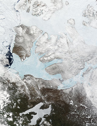
Baffin Island, in the Canadian territory of Nunavut, is the largest island in Canada and the fifth-largest island in the world. Its area is 507,451 km2 (195,928 sq mi) with a population density of 0.03/km2; the population was 13,039 according to the 2021 Canadian census; and it is located at 68°N70°W. It also contains the city of Iqaluit, which is the capital of Nunavut.

<span class="mw-page-title-main">Victoria Island</span> Island in Arctic Canada

Victoria Island is a large island in the Arctic Archipelago that straddles the boundary between Nunavut and the Northwest Territories of Canada. It is the eighth-largest island in the world, and at 217,291 km2 (83,897 sq mi) in area, it is Canada's second-largest island. It is nearly double the size of Newfoundland (111,390 km2 [43,010 sq mi]), and is slightly larger than the island of Great Britain (209,331 km2 [80,823 sq mi]) but smaller than Honshu (225,800 km2 [87,200 sq mi]). The western third of the island lies in the Inuvik Region of the Northwest Territories; the remainder is part of Nunavut's Kitikmeot Region. The population of 2,168 is divided among two settlements, the larger of which is Cambridge Bay (Nunavut) and the other Ulukhaktok.

<span class="mw-page-title-main">Reindeer</span> Species of deer

The reindeer or caribou is a species of deer with circumpolar distribution, native to Arctic, subarctic, tundra, boreal, and mountainous regions of Northern Europe, Siberia, and North America. It is the only representative of the genus Rangifer. More recent studies suggest the splitting of reindeer and caribou into six distinct species over their range.

<span class="mw-page-title-main">Quttinirpaaq National Park</span> National park in Nunavut, Canada

Quttinirpaaq National Park is located on the northeastern corner of Ellesmere Island in the Qikiqtaaluk Region of Nunavut, Canada. It is the second most northerly park on Earth after Northeast Greenland National Park. In Inuktitut, Quttinirpaaq means "top of the world". It was established as Ellesmere Island National Park Reserve in 1988, and the name was changed to Quttinirpaaq in 1999, when Nunavut was created, and became a national park in 2000. The reserve covers 37,775 km2 (14,585 sq mi), making it the second largest park in Canada, after Wood Buffalo National Park.

<span class="mw-page-title-main">Qikiqtaaluk Region</span> Region of Nunavut, Canada

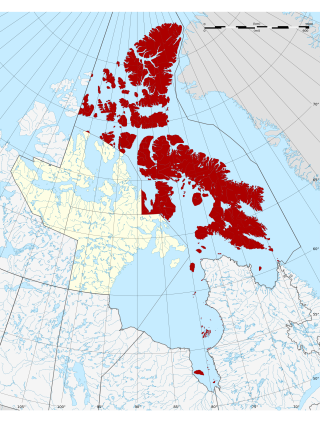
The Qikiqtaaluk Region, Qikiqtani Region or the Baffin Region is the easternmost, northernmost, and southernmost administrative region of Nunavut, Canada. Qikiqtaaluk is the traditional Inuktitut name for Baffin Island. Although the Qikiqtaaluk Region is the most commonly used name in official contexts, several notable public organizations, including Statistics Canada prior to the 2021 Canadian census, use the older term Baffin Region.

<span class="mw-page-title-main">Bathurst Island (Nunavut)</span> Uninhabited member of the Queen Elizabeth Islands, Nunavut, Canada

Bathurst Island is one of the Queen Elizabeth Islands in Nunavut, Canada. It is a member of the Arctic Archipelago. The area of the island is estimated at 16,042 km2 (6,194 sq mi), 115 to 117 mi long and from 63 mi (101 km) to 72 mi (116 km) to 92.9 mi (149.5 km) wide, making it Canada's 13th largest island. It is located between Devon Island and Cornwallis Island in the east, and Melville Island in the west. Four small islands of Cameron, Vanier, Massey and Alexander lie in its northwest.

<span class="mw-page-title-main">Wapusk National Park</span> National park in Manitoba, Canada

Wapusk National Park (; is Canada's 37th national park, established in 1996. The name comes from the Cree word for polar bear.

Pink Mountain Provincial Park is a provincial park in British Columbia, Canada.

<span class="mw-page-title-main">Torngat Mountains National Park</span> National park in Newfoundland and Labrador, Canada

Torngat Mountains National Park is a Canadian national park located on the Labrador Peninsula in the province of Newfoundland and Labrador. The park encompasses 9,700 km2 of mountainous terrain between Northern Quebec and the Labrador Sea. It is the largest national park in Atlantic Canada and the southernmost national park in the Arctic Cordillera. It partially contains the Torngat Mountains, the highest mountains in mainland Canada east of the Rocky Mountains.

<span class="mw-page-title-main">Peary caribou</span> Subspecies of deer

The Peary caribou is a subspecies of caribou found in the High Arctic islands of Nunavut and the Northwest Territories in Canada. They are the smallest of the North American caribou, with the females weighing an average of 60 kg (130 lb) and the males 110 kg (240 lb). In length the females average 1.4 m and the males 1.7 m.

<span class="mw-page-title-main">Barren-ground caribou</span> Subspecies of deer

The barren-ground caribou is a subspecies of the reindeer that is found in the Canadian territories of Nunavut and the Northwest Territories, in northern Alaska and in south-western, Greenland. It includes the Porcupine caribou of Yukon and Alaska. The barren-ground caribou is a medium-sized caribou, smaller and lighter-colored than the boreal woodland caribou, with the females weighing around 90 kg (200 lb) and the males around 150 kg (330 lb). However, on some of the smaller islands, the average weight may be less. The large migratory herds of barren-ground caribou take their names from the traditional calving grounds, such as the Ahiak herd, the Baffin Island herds, the Bathurst herd, the Beverly herd, the Bluenose East herd, the Bluenose West herd, the Porcupine herd and the Qamanirjuaq herd.

<span class="mw-page-title-main">Polar Bear Pass</span> Mountain pass in Nunavut, Canada

Polar Bear Pass, is a 262,400 hectare wetland and mountain pass on Bathurst Island within the Qikiqtaaluk Region, Nunavut, Canada. The pass is on federal Crown land.

<span class="mw-page-title-main">Dorset Island</span> Island in the Arctic Archipelago

Dorset Island or Cape Dorset Island is one of the Canadian Arctic islands located in Hudson Strait, Nunavut, Canada. It lies off the Foxe Peninsula area of southwestern Baffin Island in the Qikiqtaaluk Region. It is serviced by an airport and a harbour.

<span class="mw-page-title-main">Nirjutiqavvik National Wildlife Area</span> National Wildlife Area site in Nunavut, Canada

Nirjutiqavvik National Wildlife Area is a National Wildlife Area on Coburg Island within the Qikiqtaaluk Region, Nunavut, Canada. It is located in Baffin Bay's Lady Ann Strait between Ellesmere Island, to the north, and Devon Island to the south. The NWA includes Coburg Island and its surrounding marine area.

Seymour Island is an uninhabited island in the Qikiqtaaluk Region of northern Canada's territory of Nunavut. A member of the Berkeley Islands group, it is located approximately 30 mi (48 km) north of northern Bathurst Island. Between Seymour Island and Bathurst Island lies Helena Island. Penny Strait lies about 90 km (56 mi) to the east where open water polynyas occur.

<span class="mw-page-title-main">Qausuittuq National Park</span> National park in Nunavut, Canada

Qausuittuq National Park is a national park located on northwest Bathurst Island in Nunavut. It was established on September 1, 2015, becoming Canada's 45th national park.

<span class="mw-page-title-main">Dolphin-Union caribou</span> Migratory population of caribou

Dolphin and Union Caribou, Dolphin and Union caribou herd, Dolphin-Union, locally known as Island Caribou, are a migratory population of barren-ground caribou, Rangifer tarandus groenlandicus, that occupy Victoria Island in the Canadian Arctic Archipelago and the nearby mainland. They are endemic to Canada. They migrate across the Dolphin and Union Strait from their summer grazing on Victoria Island to their winter grazing area on the Nunavut-Northwest Territories mainland in Canada. It is unusual for North American caribou to seasonally cross sea ice and the only other caribou to do so are the Peary caribou who are smaller in size and population. They were listed as Endangered by Committee on the Status of Endangered Wildlife in Canada (COSEWIC) since November 2017.

<span class="mw-page-title-main">Southern Hudson Bay taiga</span> Taiga ecoregion of Canada

The Southern Hudson Bay taiga is a terrestrial ecoregion, as classified by the World Wildlife Fund, which extends along the southern coast of Hudson Bay and resides within the larger taiga biome. The region is nearly coterminous with the Hudson Plain, a Level I ecoregion of North America as designated by the Commission for Environmental Cooperation (CEC) in its North American Environmental Atlas.

Caribou herds in Canada are discrete populations of seven subspecies that are represented in Canada. Caribou can be found from the High Arctic region south to the boreal forest and Rocky Mountains and from the east to the west coasts.

<span class="mw-page-title-main">Low Arctic tundra</span> Tundra ecoregion of Canada

The Canadian Low Arctic Tundra ecoregion covers a rolling landscape of shrubby tundra vegetation along the northern edge of the mainland Canada along the border of the Northwest Territories and Nunavut, and a small portion in Quebec on the northeast coast of Hudson Bay. The region is important for large herds of caribou and other large mammals, and for large nesting colonies of birds such as snow geese. The region is mostly intact, with 95% remaining intact.

References

  1. "Polar Bear Pass". Ramsar Sites Information Service. Retrieved 25 April 2018.
  2. 1 2 "Polar Bear Pass National Wildlife Area". Environment Canada . Retrieved 15 August 2014.
  3. "Qausuittuq National Park". Parks Canada . Retrieved 8 August 2017.
  4. 1 2 "Polar Bear Pass". mpaglobal.org. Archived from the original on 3 February 2018. Retrieved 15 August 2014.
  5. 1 2 3 Canada, Environment and Climate Change (14 October 2011). "Polar Bear Pass (Nanuit Itillinga) National Wildlife Area". www.canada.ca. Retrieved 13 October 2022.
  6. 1 2 3 4 5 6 7 8 9 10 Government of Canada, Environment Canada. "Polar Bear Pass Wildlife Area Management Plan" (PDF). publications.gc.ca. Retrieved 14 October 2022.
  7. 1 2 3 4 Environment Canada, Ramsar. "Canada 11: Polar Bear Pass National Wildlife Area, Nunavut Territory" (PDF).{{cite journal}}: Cite journal requires |journal= (help)
  8. 1 2 Canada, Environment and Climate Change (14 October 2011). "Polar Bear Pass (Nanuit Itillinga) National Wildlife Area". www.canada.ca. Retrieved 13 October 2022.
  9. Government of Canada, Public Services and Procurement Canada. "Polar Bear Pass (Nanuit Itillinga) National Wildlife Area" (PDF). publications.gc.ca. Retrieved 13 October 2022.
  10. 1 2 Government of Canada, Public Services and Procurement Canada. "Polar Bear Pass National Wildlife Area Management Plan" (PDF). publications.gc.ca. Retrieved 13 October 2022.
  11. Government of Canada, Public Services and Procurement Canada. "Polar Bear Pass National Wildlife Area Pamphlet" (PDF). publications.gc.ca. Retrieved 13 October 2022.
  12. 1 2 "Inuit History and Heritage" (PDF). 5000YearHeritage_0.pdf. 7 November 2022. Retrieved 7 November 2022.
  13. "Nunavut". indigenouspeoplesatlasofcanada.ca. Retrieved 8 November 2022.
  14. 1 2 "Qikiqtaaluk". Territories of Life. Retrieved 8 November 2022.
  15. 1 2 3 4 5 6 7 Canada, Environment and Climate Change (14 October 2011). "Polar Bear Pass (Nanuit Itillinga) National Wildlife Area". www.canada.ca. Retrieved 8 November 2022.
  16. "Red Phalarope (Phalaropus fulicarius)". wildlife-species.canada.ca. Retrieved 8 November 2022.
  17. 1 2 Canada, Environment and Climate Change (25 November 2019). "Polar Bear (Ursus maritimus): COSEWIC assessment and status report 2018". www.canada.ca. Retrieved 8 November 2022.
  18. "Species at risk registry". species-registry.canada.ca. Retrieved 8 November 2022.
  19. "Polar Bear | CITES". cites.org. Retrieved 8 November 2022.
  20. 1 2 Canada, Environment and Climate Change (28 July 2016). "COSEWIC Assessment and Status Report on the Peary Caribou Rangifer tarandus pearyi in Canada - 2015". www.canada.ca. Retrieved 8 November 2022.
  21. Canada, Environment and Climate Change (29 July 2021). "Peary Caribou (Rangifer tarandus pearyi): recovery strategy proposed 2021". www.canada.ca. Retrieved 8 November 2022.
  22. Branch, Legislative Services (21 May 2004). "Consolidated federal laws of Canada, Nunavut Land Claims Agreement Act". laws-lois.justice.gc.ca. Retrieved 8 November 2022.
  23. 1 2 Canada, Environment and Climate Change (14 October 2011). "Polar Bear Pass (Nanuit Itillinga) National Wildlife Area". www.canada.ca. Retrieved 13 October 2022.
  24. "AGREEMENT BETWEEN THE INUIT OF THE NUNAVUT SETTLEMENT AREA AND HER MAJESTY THE QUEEN IN RIGHT OF CANADA" (PDF). Nunavut Land Claims Agreement. 25 May 1993. Retrieved 7 November 2022.
  25. "Chapter 14". Teaching and Learning. Retrieved 8 November 2022.
  26. Government of Canada, Public Services and Procurement Canada. "Information archivée dans le Web" (PDF). publications.gc.ca. Retrieved 8 November 2022.