
William Bay National Park is a national park in the Great Southern region of Western Australia, 369 km (229 mi) southeast of Perth and between the towns of Denmark and Walpole.
Sir William Edward Parry was a Royal Navy officer and explorer best known for his 1819–1820 expedition through the Parry Channel, probably the most successful in the long quest for the Northwest Passage, until it was finally negotiated by Roald Amundsen in 1906. In 1827, Parry attempted one of the earliest expeditions to the North Pole. He reached 82° 45' N, setting a record for human exploration Farthest North that stood for nearly five decades before being surpassed at 83° 20' N by Albert Hastings Markham in 1875.

Parry Sound is a town in Ontario, Canada, located on the eastern shore of the sound after which it is named. Parry Sound is located 160 km (99 mi) south of Sudbury and 225 km (140 mi) north of Toronto. It is a single-tier government located in the territorial District of Parry Sound, which has no second-tier county, regional, or district level of government. Parry Sound is a popular cottage country region for Southern Ontario residents. It also has the world's deepest natural freshwater port.

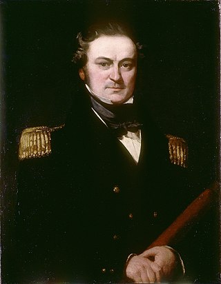
Admiral Sir Graham Moore was a Royal Navy officer. As a junior officer he took part in the Great Siege of Gibraltar during the American Revolutionary War. As captain of the frigate Melampus, he took part in the Battle of Tory Island in October 1798, capturing the Résolue two days later, during the French Revolutionary Wars. He went on to be First Naval Lord, then Commander-in-Chief, Mediterranean Fleet, and finally, Commander-in-Chief, Plymouth. He was the younger brother of General Sir John Moore.
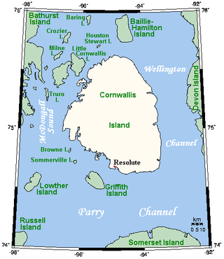
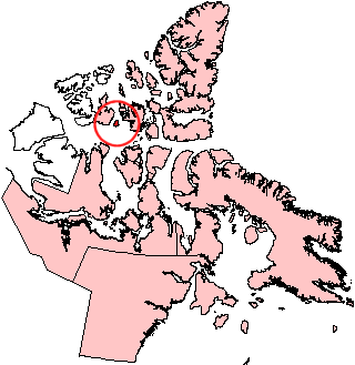
Cornwallis Island is one of the Queen Elizabeth Islands, part of the Arctic Archipelago, in the Qikiqtaaluk Region of Nunavut in the Canadian Arctic. It lies to the west of Devon Island, the largest uninhabited island in the world, and at its greatest length is about 113 km (70 mi). At 6,995 km2 (2,701 sq mi) in size, it is the 96th largest island in the world, and Canada's 21st largest island. Cornwallis Island is separated by the Wellington Channel from Devon Island, and by the Parry Channel from Somerset Island to the south. Northwest of Cornwallis Island lies Little Cornwallis Island, the biggest of a group of small islands at the north end of McDougall Sound, which separates Cornwallis Island from nearby Bathurst Island.

Bylot Island lies off the northern end of Baffin Island in Nunavut Territory, Canada. Eclipse Sound to the southeast and Navy Board Inlet to the southwest separate it from Baffin Island. Parry Channel lies to its northwest. At 11,067 km2 (4,273 sq mi) it is ranked 71st largest island in the world and Canada's 17th largest island. The island measures 180 km (110 mi) east to west and 110 km (68 mi) north to south and is one of the largest uninhabited islands in the world. While there are no permanent settlements on this Canadian Arctic island, Inuit from Pond Inlet and elsewhere regularly travel to Bylot Island. An Inuit seasonal hunting camp is located southwest of Cape Graham Moore.
Byam Martin Island (BEI-uhm) is one of the uninhabited members of the Queen Elizabeth Islands in the Canadian arctic islands located on the northern side of the Viscount Melville Sound in the territory of Nunavut. It is separated from the eastern coast of Melville Island, 27 km (17 mi) to the west, by the Byam Martin Channel; and from Bathurst Island, 35 km (22 mi) to the northeast, by the Austin Channel.

George Francis Lyon was an English naval officer and explorer of Africa and the Arctic. While not having a particularly distinguished career, he is remembered for the entertaining journals he kept and for the pencil drawings he completed in the Arctic; this information was useful to later expeditions.
Beechey Island is an island located in the Arctic Archipelago of Nunavut, Canada, in Wellington Channel. It is separated from the southwest corner of Devon Island by Barrow Strait. Other features include Wellington Channel, Erebus Harbour, and Terror Bay.

The Gulf of Boothia is a body of water in Nunavut, Canada. Administratively it is divided between the Kitikmeot Region on the west and the Qikiqtaaluk Region on the east. It merges north into Prince Regent Inlet, the two forming a single bay with different names for its parts. It is surrounded by, clockwise, Baffin Island, Fury and Hecla Strait, the Melville Peninsula, the Canadian mainland, and the Boothia Peninsula. The south end is Committee Bay, northwest of which are the Simpson Peninsula and Pelly Bay. On the west side of the gulf at 70°18′N91°42′W, north of Pelly Bay and Thom Bay, is Eden Bay, which should not be confused with a bay of the same name in the Qikiqtaaluk Region.

Fury and Hecla Strait is a narrow Arctic seawater channel located in the Qikiqtaaluk Region of Nunavut, Canada.

HMS Griper was a Bold-class gun-brig of the British Royal Navy, built in 1813 by Mark Williams and John Davidson at Hythe. She participated in the 1819 expedition to the Arctic led by William Parry, made a voyage to Greenland and Norway in 1823, and took part in Parry's third expedition in 1824 as a support ship. Her crew in 1819, 1823, or 1824, qualified for the "Arctic Medal", which the Admiralty issued in 1857. She was eventually broken up in 1868.

Duke of York Bay is an arm of Foxe Basin, in the Qikiqtaaluk Region of Nunavut, Canada. It is located in northeastern Southampton Island. The bay is directly south of the southern end of Qikiqtaaluk, with Comer Strait at the western entrance and Falcon Strait at the eastern entrance.

Roes Welcome Sound is a long channel at the northwest end of Hudson Bay in the Kivalliq Region, Nunavut, Canada between the mainland on the west and Southampton Island on the east. It opens south into Hudson Bay. Its north end joins Repulse Bay which is connected east through Frozen Strait to Foxe Basin, thereby making Southampton Island an island. Wager Bay is a western branch. It is situated 200 km (120 mi) north of Marble Island. Roes Welcome Sound measures 290 km (180 mi) long, and 24 to 113 km wide.
Lowther Island lies within the Arctic Archipelago in the Qikiqtaaluk Region of northern Canada's territory of Nunavut. It is one of the mid-channel islands in the western sector of Barrow Strait. Bathurst Island and Cornwallis Island are to the north, while Prince of Wales Island is to the south. The island is clustered within a group of uninhabited islands. It is 15.5 mi (24.9 km) northeast of Young Island, separated by the Kettle Passage, a shipping route, and 13 mi (21 km) southeast of Garrett Island, separated by Hayes Channel.
Tasiujaq formerly Murray Maxwell Bay is an uninhabited waterway in the Qikiqtaaluk Region, Nunavut, Canada. It is located in the Foxe Basin, north of Baffin Island's Siorarsuk Peninsula. Kapuiviit lies at the opening of the bay.
Captain Henry Parkyns Hoppner was an officer of the Royal Navy, Arctic explorer, draughtsman and artist. His career included two ill-fated voyages culminating in the loss of HMS Alceste in 1816 and HMS Fury in 1825.
Saglirjuaq formerly Liddon Island is one of several irregularly shaped islands located in the Fury and Hecla Strait of Nunavut's Qikiqtaaluk Region within the northern Canadian Arctic. It is north of the mainland's Melville Peninsula, south of Baffin Island's Sikosak Bay, west of Simialuk, and east of Saglaarjuk.
Maxwell Bay is a waterway in Qikiqtaaluk Region, Nunavut, Canada. It lies off the southern coast of Devon Island in the eastern high Arctic. Like Croker Bay to the east, it is an arm of Lancaster Sound and Barrow Strait.
Skene Bay is an Arctic waterway in Qikiqtaaluk Region, Nunavut, Canada. Located off southern Melville Island, the bay is an arm of Viscount Melville Sound.
